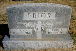
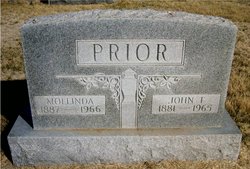
Mollinda Johnston Prior
| Birth | : | 9 Feb 1888 Tescott, Ottawa County, Kansas, USA |
| Death | : | 11 Sep 1966 Minneapolis, Ottawa County, Kansas, USA |
| Burial | : | Sugar Creek Cemetery, Rushville, Buchanan County, USA |
| Coordinate | : | 39.5569470, -95.0016120 |
| Description | : | Minneapolis Messenger, Sept. 15, 1966, page 1: MRS. JOHN PRIOR Molinda Prior of Ada died at the Ottawa County Hospital, Sunday, Sept. 11, 1966. She was born February 9, 1888 at Tescott, Kansas. She had lived most of her life in the Tescott and Ada communities. For the past two years she had been cared for at the Clark rest home in Minneapolis. On September 7, 1917 she was united in marriage to John Prior of Ada, who preceded her in death September, 1965. Survivors include a brother, Albert Johnston of Salina, a nephew Herbert Mull of Minneapolis, Route one; also several other nephews and... Read More |
frequently asked questions (FAQ):
-
Where is Mollinda Johnston Prior's memorial?
Mollinda Johnston Prior's memorial is located at: Sugar Creek Cemetery, Rushville, Buchanan County, USA.
-
When did Mollinda Johnston Prior death?
Mollinda Johnston Prior death on 11 Sep 1966 in Minneapolis, Ottawa County, Kansas, USA
-
Where are the coordinates of the Mollinda Johnston Prior's memorial?
Latitude: 39.5569470
Longitude: -95.0016120
Family Members:
Spouse
Flowers:
Nearby Cemetories:
1. Sugar Creek Cemetery
Rushville, Buchanan County, USA
Coordinate: 39.5569470, -95.0016120
2. Elliott Cemetery
Buchanan County, USA
Coordinate: 39.5582200, -95.0079900
3. Brown Cemetery
Rushville, Buchanan County, USA
Coordinate: 39.5606500, -94.9935300
4. Gore Cemetery
Buchanan County, USA
Coordinate: 39.5489006, -95.0147018
5. Allison Homestead Graveyard
Rushville, Buchanan County, USA
Coordinate: 39.5659100, -95.0211900
6. Fist Cemetery
Buchanan County, USA
Coordinate: 39.5763000, -95.0014000
7. Connor Cemetery
Buchanan County, USA
Coordinate: 39.5634000, -94.9778000
8. Cash Cemetery
Rushville, Buchanan County, USA
Coordinate: 39.5702400, -95.0220600
9. Black Family Cemetery
Rushville, Buchanan County, USA
Coordinate: 39.5773500, -94.9898400
10. Foley Cemetery
Sugar Lake, Buchanan County, USA
Coordinate: 39.5333000, -94.9905800
11. Gordon Graveyard
Rushville, Buchanan County, USA
Coordinate: 39.5607400, -95.0352900
12. Hutson Cemetery
Platte County, USA
Coordinate: 39.5297500, -95.0000700
13. Daniel Jones Cemetery
Rushville, Buchanan County, USA
Coordinate: 39.5852318, -94.9851913
14. Schmidt Graves
Rushville, Buchanan County, USA
Coordinate: 39.5616330, -95.0416950
15. Hudspeth Cemetery
Rushville, Buchanan County, USA
Coordinate: 39.5682100, -95.0400000
16. Coleman Cemetery
Platte County, USA
Coordinate: 39.5241200, -95.0180500
17. Dicksen Cemetery
Rushville, Buchanan County, USA
Coordinate: 39.5889100, -95.0220400
18. Blythe Family Cemetery
Platte County, USA
Coordinate: 39.5226500, -94.9832800
19. Fenton Grave
Buchanan County, USA
Coordinate: 39.5923700, -94.9844900
20. Armstrong Cemetery
Rushville, Buchanan County, USA
Coordinate: 39.5960999, -95.0083008
21. Bellis Cemetery
Platte County, USA
Coordinate: 39.5142400, -94.9933800
22. Dunlap Cemetery
Mock Corner, Buchanan County, USA
Coordinate: 39.5473500, -94.9446500
23. Bean Family Cemetery
Bean Lake Station, Platte County, USA
Coordinate: 39.5108200, -95.0100900
24. Brumley Cemetery
De Kalb, Buchanan County, USA
Coordinate: 39.5585000, -94.9398000


