
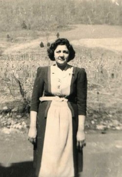
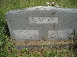
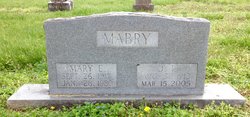
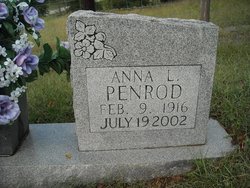
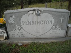
Mrs Mary Elizabeth Pennington Lynn Mabry
| Birth | : | 26 Sep 1917 Celina, Clay County, Tennessee, USA |
| Death | : | 28 Jan 1980 Indiana, USA |
| Burial | : | Saint Mary Magdalene Church, Barwick, South Somerset District, England |
| Coordinate | : | 50.9225000, -2.6302000 |
| Description | : | First Marriage Was Malcom Lynn Second Was Jay Thomas Mabry |
frequently asked questions (FAQ):
-
Where is Mrs Mary Elizabeth Pennington Lynn Mabry's memorial?
Mrs Mary Elizabeth Pennington Lynn Mabry's memorial is located at: Saint Mary Magdalene Church, Barwick, South Somerset District, England.
-
When did Mrs Mary Elizabeth Pennington Lynn Mabry death?
Mrs Mary Elizabeth Pennington Lynn Mabry death on 28 Jan 1980 in Indiana, USA
-
Where are the coordinates of the Mrs Mary Elizabeth Pennington Lynn Mabry's memorial?
Latitude: 50.9225000
Longitude: -2.6302000
Family Members:
Parent


Spouse

Siblings


Children
Flowers:


Nearby Cemetories:
1. Saint Mary Magdalene Church
Barwick, South Somerset District, England
Coordinate: 50.9225000, -2.6302000
2. Barwick Extension Cemetery
Barwick, South Somerset District, England
Coordinate: 50.9225700, -2.6310700
3. East Coker Cemetery
East Coker, South Somerset District, England
Coordinate: 50.9104300, -2.6546930
4. St. Michael and All Angels Churchyard
East Coker, South Somerset District, England
Coordinate: 50.9073181, -2.6572940
5. St Mary the Virgin Churchyard
Bradford Abbas, West Dorset District, England
Coordinate: 50.9264090, -2.5884500
6. St. James's Churchyard
Preston Plucknett, South Somerset District, England
Coordinate: 50.9437800, -2.6635960
7. Saint Roch Church Churchyard
South Somerset District, England
Coordinate: 50.8923000, -2.6198000
8. St. Hippolytus Churchyard
Ryme Intrinseca, West Dorset District, England
Coordinate: 50.8956530, -2.5962310
9. St Andrew's Churchyard
Brympton, South Somerset District, England
Coordinate: 50.9358500, -2.6855500
10. St. Michael’s Churchyard
Beer Hackett, West Dorset District, England
Coordinate: 50.9040180, -2.5703420
11. St Michael's Churchyard
Over Compton, West Dorset District, England
Coordinate: 50.9500000, -2.5784000
12. St Marys Churchyard
Hardington Mandeville, South Somerset District, England
Coordinate: 50.9046300, -2.6954050
13. Lufton Anglican Churchyard
Lufton, South Somerset District, England
Coordinate: 50.9491080, -2.6917910
14. Nether Compton Cemetery
Nether Compton, West Dorset District, England
Coordinate: 50.9531610, -2.5732420
15. St Nicholas Churchyard
Nether Compton, West Dorset District, England
Coordinate: 50.9531610, -2.5732420
16. St. Peter and St. Paul's Churchyard
Odcombe, South Somerset District, England
Coordinate: 50.9365190, -2.7031239
17. Mudford Parish Cemetery
Mudford, South Somerset District, England
Coordinate: 50.9708040, -2.6114880
18. St. Mary's Churchyard
East Chinnock, South Somerset District, England
Coordinate: 50.9164240, -2.7145142
19. St. Mary's Churchyard
Halstock, West Dorset District, England
Coordinate: 50.8703000, -2.6555900
20. St. Osmond's Churchyard
Melbury Osmond, West Dorset District, England
Coordinate: 50.8684120, -2.6067439
21. Blessed Virgin Mary Churchyard
Mudford, South Somerset District, England
Coordinate: 50.9773210, -2.6086310
22. Blessed Virgin Mary Churchyard
Chilthorne Domer, South Somerset District, England
Coordinate: 50.9721100, -2.6783950
23. St. Catherine's Churchyard
Montacute, South Somerset District, England
Coordinate: 50.9495420, -2.7178200
24. Montacute Priory
Montacute, South Somerset District, England
Coordinate: 50.9489820, -2.7183880