

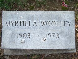
Myrtilla Woolley Nash
| Birth | : | 29 Dec 1903 Shelburn, Sullivan County, Indiana, USA |
| Death | : | 19 Apr 1970 Sullivan, Sullivan County, Indiana, USA |
| Burial | : | Flaybrick Memorial Gardens, Birkenhead, Metropolitan Borough of Wirral, England |
| Coordinate | : | 53.3968130, -3.0633240 |
| Description | : | Married to Coleman D. Nash on May 17, 1924. OBITUARY: Myrtilla Nash, 66 Succumbs To Illness Mrs. Myrtilla Nash, 66, of 217 W. Wolfe Street, died at 10:30 p.m. Sunday at Mary Sherman Hospital after an extended illness. She was the wife of longtime local businessman, Coleman Nash. Mrs. Nash was a member of the Shelburn First Baptist Church, OES at Shelburn, and was a retired school teacher. She taught at Shelburn, Graysville, Sullivan High School and ISU business department before retiring in 1963. Surviving besides the husband are the mother, Mrs. Myrtie Woolley, Shelburn; a brother,... Read More |
frequently asked questions (FAQ):
-
Where is Myrtilla Woolley Nash's memorial?
Myrtilla Woolley Nash's memorial is located at: Flaybrick Memorial Gardens, Birkenhead, Metropolitan Borough of Wirral, England.
-
When did Myrtilla Woolley Nash death?
Myrtilla Woolley Nash death on 19 Apr 1970 in Sullivan, Sullivan County, Indiana, USA
-
Where are the coordinates of the Myrtilla Woolley Nash's memorial?
Latitude: 53.3968130
Longitude: -3.0633240
Family Members:
Spouse
Flowers:


Nearby Cemetories:
1. Flaybrick Memorial Gardens
Birkenhead, Metropolitan Borough of Wirral, England
Coordinate: 53.3968130, -3.0633240
2. St Oswald's Churchyard
Bidston, Metropolitan Borough of Wirral, England
Coordinate: 53.4043400, -3.0791000
3. Salacre Lane Cemetery
Upton, Metropolitan Borough of Wirral, England
Coordinate: 53.3824050, -3.0919920
4. Saint Mary's Churchyard
Upton, Metropolitan Borough of Wirral, England
Coordinate: 53.3847010, -3.0961600
5. St Alban's Catholic Church
Wallasey, Metropolitan Borough of Wirral, England
Coordinate: 53.4181339, -3.0445808
6. St Hilary Churchyard
Wallasey, Metropolitan Borough of Wirral, England
Coordinate: 53.4216480, -3.0601780
7. St. Werburgh & St. Laurence Catholic Churchyard
Birkenhead, Metropolitan Borough of Wirral, England
Coordinate: 53.3894910, -3.0217530
8. St. John the Evangelist Churchyard
Egremont, Metropolitan Borough of Wirral, England
Coordinate: 53.4163500, -3.0329700
9. Holy Cross Churchyard
Woodchurch, Metropolitan Borough of Wirral, England
Coordinate: 53.3731900, -3.0899400
10. Christ Church Churchyard
Moreton, Metropolitan Borough of Wirral, England
Coordinate: 53.3999580, -3.1112310
11. Rake Lane Cemetery
Wallasey, Metropolitan Borough of Wirral, England
Coordinate: 53.4256120, -3.0437320
12. St. Mary's Churchyard
Birkenhead, Metropolitan Borough of Wirral, England
Coordinate: 53.3895930, -3.0112520
13. Landican Cemetery and Crematorium
Woodchurch, Metropolitan Borough of Wirral, England
Coordinate: 53.3654000, -3.0887510
14. St Paul's
Tranmere, Metropolitan Borough of Wirral, England
Coordinate: 53.3740000, -3.0154600
15. Liverpool Naval Memorial
Liverpool, Metropolitan Borough of Liverpool, England
Coordinate: 53.4061220, -2.9981050
16. St. Nicholas' Churchyard
Liverpool, Metropolitan Borough of Liverpool, England
Coordinate: 53.4069350, -2.9951480
17. St. George's Churchyard
Liverpool, Metropolitan Borough of Liverpool, England
Coordinate: 53.4049700, -2.9901030
18. Christ Church
Bebington, Metropolitan Borough of Wirral, England
Coordinate: 53.3584460, -3.0254810
19. St. Paul's Churchyard
Liverpool, Metropolitan Borough of Liverpool, England
Coordinate: 53.4099460, -2.9919370
20. St. Peter's Churchyard
Bebington, Metropolitan Borough of Wirral, England
Coordinate: 53.3692500, -3.0021020
21. St. Thomas Churchyard
Liverpool, Metropolitan Borough of Liverpool, England
Coordinate: 53.4010330, -2.9861190
22. Bebington Cemetery
Bebington, Metropolitan Borough of Wirral, England
Coordinate: 53.3588030, -3.0165370
23. St. John the Divine
Frankby, Metropolitan Borough of Wirral, England
Coordinate: 53.3744200, -3.1330200
24. St. Peter's Churchyard
Liverpool, Metropolitan Borough of Liverpool, England
Coordinate: 53.4051290, -2.9844200