


Myrtle Florence “Minnie” Potts Trapp
| Birth | : | 8 Sep 1895 Lake City, Calhoun County, Iowa, USA |
| Death | : | 24 Jan 1981 Redfield, Spink County, South Dakota, USA |
| Burial | : | Roseland Memorial Gardens, Jackson, Jackson County, USA |
| Coordinate | : | 42.1982994, -84.3486023 |
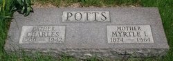
| Inscription | : | Family Marker: Trapp Individual Marker: Mother Minnie F. 1895-1981 |
| Description | : | Funeral services for Minnie Florence Trapp, 85, Conde, were Tuesday, Jan. 27, 1981 at the Conde Methodist Church. Burial was in the Conde Cemetery under the direction of Thelen Funeral Home, Redfield. Pallbearers were Bill Trapp, * Trapp, Charles Trapp III, Gary Trapp, * Stahly and * Styles. Mrs. Trapp died Saturday, Jan. 24 at Redfield Community Memorial Hospital. She was born Sept. 8, 1895 at Lake City, Iowa to Charles and Myrtle Potts. She attended school in Iowa and moved with her parents to Montana Where They homesteaded around Sumatra Montana. ... Read More |
frequently asked questions (FAQ):
-
Where is Myrtle Florence “Minnie” Potts Trapp's memorial?
Myrtle Florence “Minnie” Potts Trapp's memorial is located at: Roseland Memorial Gardens, Jackson, Jackson County, USA.
-
When did Myrtle Florence “Minnie” Potts Trapp death?
Myrtle Florence “Minnie” Potts Trapp death on 24 Jan 1981 in Redfield, Spink County, South Dakota, USA
-
Where are the coordinates of the Myrtle Florence “Minnie” Potts Trapp's memorial?
Latitude: 42.1982994
Longitude: -84.3486023
Family Members:
Parent

Spouse
Siblings


Children
Flowers:


Nearby Cemetories:
1. Roseland Memorial Gardens
Jackson, Jackson County, USA
Coordinate: 42.1982994, -84.3486023
2. Eldred Cemetery
Napoleon, Jackson County, USA
Coordinate: 42.1969860, -84.3403940
3. Draper Cemetery (Defunct)
Vandercook Lake, Jackson County, USA
Coordinate: 42.1835000, -84.3849600
4. Saint Johns Catholic Cemetery
Jackson, Jackson County, USA
Coordinate: 42.2202988, -84.3914032
5. Woodland Cemetery
Jackson, Jackson County, USA
Coordinate: 42.2206001, -84.3972015
6. Page Avenue Baptist Church Cemetery
Michigan Center, Jackson County, USA
Coordinate: 42.2327000, -84.3090000
7. McArthur Cemetery
Leoni, Jackson County, USA
Coordinate: 42.2565400, -84.3394700
8. Cradit Cemetery
Jackson, Jackson County, USA
Coordinate: 42.2574997, -84.3531036
9. East Main Street Cemetery
Jackson, Jackson County, USA
Coordinate: 42.2507900, -84.3900600
10. Mount Evergreen Cemetery
Jackson, Jackson County, USA
Coordinate: 42.2378006, -84.4111023
11. Saint Pauls Episcopal Church Memorial Garden
Jackson, Jackson County, USA
Coordinate: 42.2455080, -84.4086940
12. South Jackson Cemetery
Jackson, Jackson County, USA
Coordinate: 42.1605170, -84.4277970
13. Leoni Cemetery
Leoni, Jackson County, USA
Coordinate: 42.2406750, -84.2695520
14. Westminster United Presbyterian Memorial Garden
Jackson, Jackson County, USA
Coordinate: 42.1998550, -84.4471190
15. Michigan State Prison Cemetery (Defunct)
Jackson, Jackson County, USA
Coordinate: 42.2587390, -84.4046580
16. McNaughton Cemetery
Jackson, Jackson County, USA
Coordinate: 42.2689250, -84.3849990
17. Temple Beth Israel Cemetery
Jackson, Jackson County, USA
Coordinate: 42.2530000, -84.4220000
18. Hillcrest Memorial Park
Jackson, Jackson County, USA
Coordinate: 42.2712990, -84.3839370
19. Clarklake Cemetery
Clarklake, Jackson County, USA
Coordinate: 42.1192360, -84.3450470
20. Snyder Cemetery
Liberty, Jackson County, USA
Coordinate: 42.1605720, -84.4461110
21. East Liberty Cemetery
Liberty, Jackson County, USA
Coordinate: 42.1182327, -84.3783722
22. Odd Fellows Cemetery
Jackson, Jackson County, USA
Coordinate: 42.2477640, -84.4392550
23. Crossroads Animal Hospital Burial Site
Jackson, Jackson County, USA
Coordinate: 42.2823180, -84.3647750
24. Oak Grove Cemetery
Napoleon, Jackson County, USA
Coordinate: 42.1549416, -84.2489166