

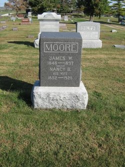
Nancy B. Gillis Moore
| Birth | : | 23 Mar 1852 Vermont, USA |
| Death | : | 3 Aug 1925 Nodaway County, Missouri, USA |
| Burial | : | Liberty Cemetery, Calumet, O'Brien County, USA |
| Coordinate | : | 42.9241982, -95.5932999 |
| Plot | : | Sec 7, Row 20, s-n |
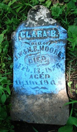
| Inscription | : | Wife of James W. Moore |
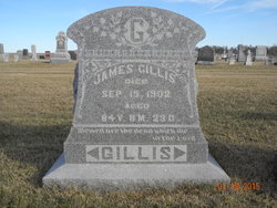
| Description | : | Father: James Gillis, b: Ireland. |
frequently asked questions (FAQ):
-
Where is Nancy B. Gillis Moore's memorial?
Nancy B. Gillis Moore's memorial is located at: Liberty Cemetery, Calumet, O'Brien County, USA.
-
When did Nancy B. Gillis Moore death?
Nancy B. Gillis Moore death on 3 Aug 1925 in Nodaway County, Missouri, USA
-
Where are the coordinates of the Nancy B. Gillis Moore's memorial?
Latitude: 42.9241982
Longitude: -95.5932999
Family Members:
Parent

Spouse
Siblings
Children


Nearby Cemetories:
1. Liberty Cemetery
Calumet, O'Brien County, USA
Coordinate: 42.9241982, -95.5932999
2. Friends Cemetery
Mapleside, O'Brien County, USA
Coordinate: 43.0022000, -95.6225000
3. Waterman Cemetery
Sutherland, O'Brien County, USA
Coordinate: 42.9664001, -95.4847031
4. Calvary Cemetery
Sutherland, O'Brien County, USA
Coordinate: 42.9686012, -95.4858017
5. Prairie View Cemetery
Paullina, O'Brien County, USA
Coordinate: 42.9688988, -95.7022018
6. West Prairie View Cemetery
Paullina, O'Brien County, USA
Coordinate: 42.9688988, -95.7039032
7. Liberty Cemetery
Meriden, Cherokee County, USA
Coordinate: 42.8368988, -95.6361008
8. Cedar Cemetery
Larrabee, Cherokee County, USA
Coordinate: 42.8361015, -95.5346985
9. Cherokee County Pioneer Cemetery
Spring Township, Cherokee County, USA
Coordinate: 42.8502998, -95.4906006
10. Fred Feldman Grave
Waterman Township, O'Brien County, USA
Coordinate: 42.9178590, -95.4433340
11. Hannibal H Waterman Cemetery
O'Brien County, USA
Coordinate: 42.9375530, -95.4170760
12. Saint John Cemetery
Germantown, O'Brien County, USA
Coordinate: 42.9566994, -95.7799988
13. Afton Cemetery
Cherokee County, USA
Coordinate: 42.8064003, -95.4863968
14. Meriden Cemetery
Meriden, Cherokee County, USA
Coordinate: 42.7868996, -95.6425018
15. Doyle Cemetery
Highland Township, O'Brien County, USA
Coordinate: 43.0619011, -95.5243988
16. Memory Gardens
Cherokee, Cherokee County, USA
Coordinate: 42.7778015, -95.5580978
17. Mount Calvary Cemetery
Cherokee, Cherokee County, USA
Coordinate: 42.7639008, -95.5847015
18. Covey Church Cemetery
Hartley, O'Brien County, USA
Coordinate: 43.0682000, -95.4875000
19. Beacon Hollow Cemetery
Cherokee, Cherokee County, USA
Coordinate: 42.7572057, -95.5727856
20. George Donohoe Grave Site
Cherokee, Cherokee County, USA
Coordinate: 42.7571850, -95.5704080
21. Oak Hill Cemetery
Cherokee, Cherokee County, USA
Coordinate: 42.7496986, -95.5796967
22. Saint Johannes Cemetery
Brooke Township, Buena Vista County, USA
Coordinate: 42.8662758, -95.3669968
23. Pleasant Hill Cemetery
Primghar, O'Brien County, USA
Coordinate: 43.0980988, -95.6374969
24. Saint Anthonys Catholic Calvary Cemetery
Primghar, O'Brien County, USA
Coordinate: 43.0981930, -95.6373780