
| Memorials | : | 13 |
| Location | : | O'Brien County, USA |
| Coordinate | : | 42.9375530, -95.4170760 |
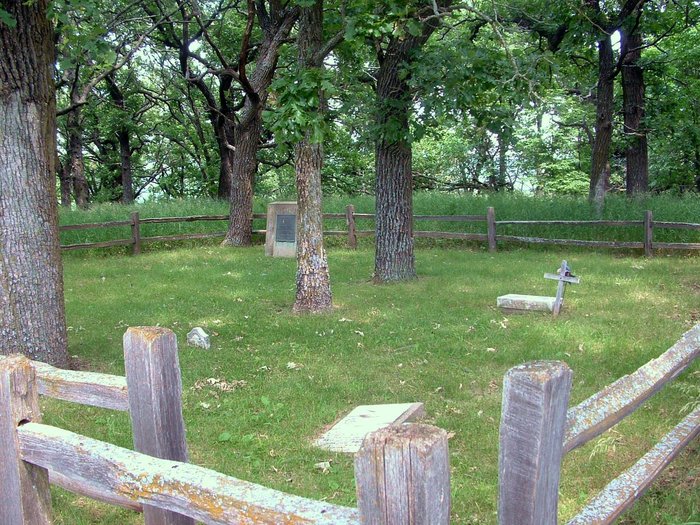
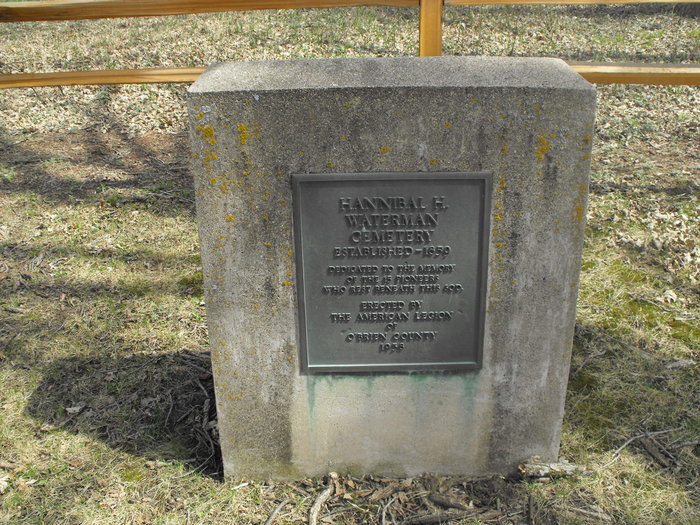
| Description | : | Waterman Township Section 26 Established in 1859: Located 1/2 mile east of the road passing the original Waterman homestead in O'Brien County, Iowa. The small family cemetery sits on the banks of the little Sioux River and is surrounded by a wooden fence. The U.S. Geological Survey (USGS) Geographic Names Information System (GNIS) feature ID for the cemetery is 1907056 (First Cemetery). |
frequently asked questions (FAQ):
-
Where is Hannibal H Waterman Cemetery?
Hannibal H Waterman Cemetery is located at 4930 Yellow Avenue O'Brien County ,Iowa , 51047USA.
-
Hannibal H Waterman Cemetery cemetery's updated grave count on graveviews.com?
0 memorials
-
Where are the coordinates of the Hannibal H Waterman Cemetery?
Latitude: 42.9375530
Longitude: -95.4170760
Nearby Cemetories:
1. Fred Feldman Grave
Waterman Township, O'Brien County, USA
Coordinate: 42.9178590, -95.4433340
2. Oakland Cemetery
Peterson, Clay County, USA
Coordinate: 42.9281006, -95.3432999
3. Waterman Cemetery
Sutherland, O'Brien County, USA
Coordinate: 42.9664001, -95.4847031
4. Calvary Cemetery
Sutherland, O'Brien County, USA
Coordinate: 42.9686012, -95.4858017
5. Saint Johannes Cemetery
Brooke Township, Buena Vista County, USA
Coordinate: 42.8662758, -95.3669968
6. Cherokee County Pioneer Cemetery
Spring Township, Cherokee County, USA
Coordinate: 42.8502998, -95.4906006
7. Clay Center Cemetery
Royal, Clay County, USA
Coordinate: 43.0410995, -95.3272018
8. Immanuel Lutheran Church Cemetery
Aurelia, Cherokee County, USA
Coordinate: 42.8165000, -95.3885000
9. Willow Creek Cemetery
Royal, Clay County, USA
Coordinate: 43.0214005, -95.2885971
10. Douglas Township Cemetery
Clay County, USA
Coordinate: 42.9255981, -95.2450027
11. Liberty Cemetery
Calumet, O'Brien County, USA
Coordinate: 42.9241982, -95.5932999
12. Zion Methodist Cemetery
Clay County, USA
Coordinate: 42.9808006, -95.2497025
13. Cedar Cemetery
Larrabee, Cherokee County, USA
Coordinate: 42.8361015, -95.5346985
14. TriMello Cemetery
Royal, Clay County, USA
Coordinate: 43.0682983, -95.3728027
15. Barnes Township Cemetery
Linn Grove, Buena Vista County, USA
Coordinate: 42.8880997, -95.2397003
16. Covey Church Cemetery
Hartley, O'Brien County, USA
Coordinate: 43.0682000, -95.4875000
17. Afton Cemetery
Cherokee County, USA
Coordinate: 42.8064003, -95.4863968
18. Plainview Cemetery
Alta, Buena Vista County, USA
Coordinate: 42.8087100, -95.3280200
19. Doyle Cemetery
Highland Township, O'Brien County, USA
Coordinate: 43.0619011, -95.5243988
20. Lincoln Cemetery
Rossie, Clay County, USA
Coordinate: 43.0111008, -95.2313995
21. Haight Family Farm Cemetery
Aurelia, Cherokee County, USA
Coordinate: 42.7778400, -95.3781060
22. Friends Cemetery
Mapleside, O'Brien County, USA
Coordinate: 43.0022000, -95.6225000
23. Little Sioux Valley Cemetery
Rembrandt, Buena Vista County, USA
Coordinate: 42.8375015, -95.2074966
24. Swedish Lutheran Cemetery
Royal, Clay County, USA
Coordinate: 43.0683000, -95.2350000