
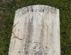
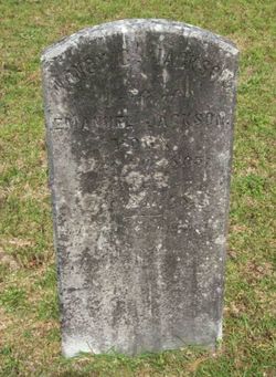
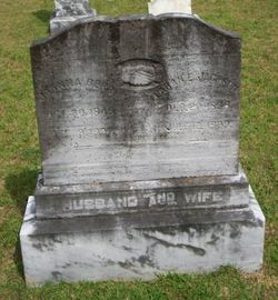
Nancy Cook Jackson
| Birth | : | 20 Dec 1805 |
| Death | : | 24 Dec 1881 |
| Burial | : | Saint Michael's Churchyard, Alnwick, Northumberland Unitary Authority, England |
| Coordinate | : | 55.4169400, -1.7111000 |
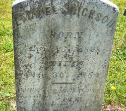
| Description | : | She was the wife of Emanuel Jackson. |
frequently asked questions (FAQ):
-
Where is Nancy Cook Jackson's memorial?
Nancy Cook Jackson's memorial is located at: Saint Michael's Churchyard, Alnwick, Northumberland Unitary Authority, England.
-
When did Nancy Cook Jackson death?
Nancy Cook Jackson death on 24 Dec 1881 in
-
Where are the coordinates of the Nancy Cook Jackson's memorial?
Latitude: 55.4169400
Longitude: -1.7111000
Family Members:
Spouse
Children
Flowers:


Nearby Cemetories:
1. Saint Michael's Churchyard
Alnwick, Northumberland Unitary Authority, England
Coordinate: 55.4169400, -1.7111000
2. Alnwick Abbey
Alnwick, Northumberland Unitary Authority, England
Coordinate: 55.4198500, -1.7191400
3. Alnwick Cemetery
Alnwick, Northumberland Unitary Authority, England
Coordinate: 55.4037170, -1.6919940
4. Hulne Priory
Alnwick, Northumberland Unitary Authority, England
Coordinate: 55.4350530, -1.7430160
5. St. Mary The Virgin Churchyard
Lesbury, Northumberland Unitary Authority, England
Coordinate: 55.3986820, -1.6277570
6. St Peter's & St Paul's Churchyard
Longhoughton, Northumberland Unitary Authority, England
Coordinate: 55.4289930, -1.6169950
7. Rock Church of St. Philip and St. James
Alnwick, Northumberland Unitary Authority, England
Coordinate: 55.4755200, -1.6817200
8. St John The Baptist Churchyard
Alnmouth, Northumberland Unitary Authority, England
Coordinate: 55.3882090, -1.6124020
9. Alnmouth Cemetery
Alnmouth, Northumberland Unitary Authority, England
Coordinate: 55.3951400, -1.6064100
10. St Michael and All Angels Churchyard
Alnwick, Northumberland Unitary Authority, England
Coordinate: 55.4506080, -1.6096700
11. Bolton Chapel
Edlingham, Northumberland Unitary Authority, England
Coordinate: 55.4168580, -1.8335818
12. St John the Baptist Churchyard
Edlingham, Northumberland Unitary Authority, England
Coordinate: 55.3758250, -1.8212200
13. Embleton Churchyard
Embleton, Northumberland Unitary Authority, England
Coordinate: 55.4884280, -1.6333460
14. St Maurice Churchyard
Eglingham, Northumberland Unitary Authority, England
Coordinate: 55.4689000, -1.8336000
15. Holy Trinity Churchyard
Embleton, Northumberland Unitary Authority, England
Coordinate: 55.4955790, -1.6360190
16. Grey Family Cemetery
Fallodon, Northumberland Unitary Authority, England
Coordinate: 55.5058580, -1.6760530
17. St Maurice's Churchyard
Ellingham, Northumberland Unitary Authority, England
Coordinate: 55.5245000, -1.7245300
18. Amble West Cemetery
Amble, Northumberland Unitary Authority, England
Coordinate: 55.3311820, -1.5922950
19. St. John the Divine Churchyard
Acklington, Northumberland Unitary Authority, England
Coordinate: 55.3106000, -1.6435000
20. Felton Cemetery
Felton, Northumberland Unitary Authority, England
Coordinate: 55.3020920, -1.7118410
21. Amble East Cemetery
Amble, Northumberland Unitary Authority, England
Coordinate: 55.3333190, -1.5696400
22. Longframlington Cemetery
Longframlington, Northumberland Unitary Authority, England
Coordinate: 55.3085440, -1.8003926
23. St Mary the Virgin Churchyard
Longframlington, Northumberland Unitary Authority, England
Coordinate: 55.3028950, -1.7952920
24. Longframlington Church Cemetery Extension
Longframlington, Northumberland Unitary Authority, England
Coordinate: 55.3014700, -1.7950600