
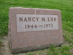
Nancy M. Miller Ehr
| Birth | : | 19 Nov 1944 Waterloo, Black Hawk County, Iowa, USA |
| Death | : | 10 Aug 1973 Delaware County, Iowa, USA |
| Burial | : | Westview Cemetery, La Porte City, Black Hawk County, USA |
| Coordinate | : | 42.3107986, -92.1699982 |
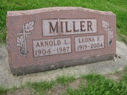
| Description | : | Progress Review, La Porte City, Iowa Wednesday, August 15, 1973, Page 9 Mrs. James (Nancy) Ehr Nancy Marie Ehr, 28, of Independence died Friday, August 10, 1973, 2 miles northeast of Masonville of a possible accidental drowning. She was born November 19, 1944 in Waterloo, Iowa, and was the daughter of Arnold Lewis Miller and Leona Frances Bedard of La Porte City. She married James Nicholas Ehr on January 19, 1966 in La Porte City. Mrs. Ehr graduated from Don Bosco High School in Gilbertville in 1963. She then worked at Mercy Hospital in Cedar Rapids where she had on-the-job training. Mrs.... Read More |
frequently asked questions (FAQ):
-
Where is Nancy M. Miller Ehr's memorial?
Nancy M. Miller Ehr's memorial is located at: Westview Cemetery, La Porte City, Black Hawk County, USA.
-
When did Nancy M. Miller Ehr death?
Nancy M. Miller Ehr death on 10 Aug 1973 in Delaware County, Iowa, USA
-
Where are the coordinates of the Nancy M. Miller Ehr's memorial?
Latitude: 42.3107986
Longitude: -92.1699982
Family Members:
Parent

Spouse
Siblings


Flowers:


Nearby Cemetories:
1. Westview Cemetery
La Porte City, Black Hawk County, USA
Coordinate: 42.3107986, -92.1699982
2. Sawyer Cemetery
La Porte City, Black Hawk County, USA
Coordinate: 42.3381004, -92.1519012
3. Engledow Cemetery
Mount Auburn, Benton County, USA
Coordinate: 42.2686996, -92.1330032
4. Anton Cemetery
La Porte City, Black Hawk County, USA
Coordinate: 42.3418999, -92.2399979
5. Mount Auburn Cemetery
Mount Auburn, Benton County, USA
Coordinate: 42.2536800, -92.0903000
6. Spring Creek Chapel Cemetery
La Porte City, Black Hawk County, USA
Coordinate: 42.3616982, -92.0783005
7. Zion Lutheran Jubilee Cemetery
Jubilee, Black Hawk County, USA
Coordinate: 42.3843050, -92.0837440
8. Greenwalt Cemetery
Mount Auburn, Benton County, USA
Coordinate: 42.2256012, -92.1038971
9. Fairview Cemetery
Benton County, USA
Coordinate: 42.2141991, -92.2007980
10. Pratt Creek Cemetery
Vinton, Benton County, USA
Coordinate: 42.2104000, -92.1307400
11. Sancta Maria Cemetery
Gilbertville, Black Hawk County, USA
Coordinate: 42.4132560, -92.2060940
12. Shady Grove Cemetery
Jesup, Buchanan County, USA
Coordinate: 42.3805453, -92.0557342
13. Saint Mary's Cemetery
Gilbertville, Black Hawk County, USA
Coordinate: 42.4188300, -92.2181200
14. Hill Cemetery
Tama County, USA
Coordinate: 42.2542000, -92.3075027
15. Saint Marys of Mount Carmel Cemetery
Waterloo, Black Hawk County, USA
Coordinate: 42.3418000, -92.3280000
16. Brown Bruce Township Cemetery
Benton County, USA
Coordinate: 42.2163430, -92.2799680
17. Washburn Cemetery
Washburn, Black Hawk County, USA
Coordinate: 42.4139200, -92.2711700
18. Brandon Cemetery
Brandon, Buchanan County, USA
Coordinate: 42.3156300, -91.9945200
19. Jefferson Township Cemetery
Brandon, Buchanan County, USA
Coordinate: 42.3139000, -91.9931030
20. Beachler Cemetery
Brandon, Buchanan County, USA
Coordinate: 42.3045000, -91.9908000
21. Spencer Cemetery
Dysart, Tama County, USA
Coordinate: 42.2592120, -92.3353840
22. Eagle Township Cemetery
Black Hawk County, USA
Coordinate: 42.3410988, -92.3525009
23. Geneseo Cemetery
Buckingham, Tama County, USA
Coordinate: 42.2764370, -92.3523950
24. Carlisle Grove Cemetery
Garrison, Benton County, USA
Coordinate: 42.1730995, -92.1386032