
| Birth | : | 2 May 1830 Giles County, Tennessee, USA |
| Death | : | 8 Oct 1880 Missouri, USA |
| Burial | : | St. Anne and Blessed Dominic Churchyard, St Helens, Metropolitan Borough of St Helens, England |
| Coordinate | : | 53.4330960, -2.7083700 |
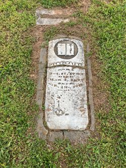
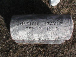
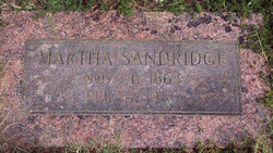
| Description | : | Daughter of James Payne and Jane (Hollis) Payne. Mother of Rachel Adele Payne and John Payne. Married Major William Russell 05/Feb/1863 at Oregon Co., MO. Mother of Martha Jane, William George, Mary "Elizabeth", James Madison, and Julyett. |
frequently asked questions (FAQ):
-
Where is Nancy Payne Russell's memorial?
Nancy Payne Russell's memorial is located at: St. Anne and Blessed Dominic Churchyard, St Helens, Metropolitan Borough of St Helens, England.
-
When did Nancy Payne Russell death?
Nancy Payne Russell death on 8 Oct 1880 in Missouri, USA
-
Where are the coordinates of the Nancy Payne Russell's memorial?
Latitude: 53.4330960
Longitude: -2.7083700
Family Members:
Parent
Spouse

Siblings
Children
Flowers:


Nearby Cemetories:
1. St. Anne and Blessed Dominic Churchyard
St Helens, Metropolitan Borough of St Helens, England
Coordinate: 53.4330960, -2.7083700
2. St Nicholas Churchyard
St Helens, Metropolitan Borough of St Helens, England
Coordinate: 53.4284660, -2.7213830
3. St Peter's of Parr Churchyard
Parr, Metropolitan Borough of St Helens, England
Coordinate: 53.4543745, -2.7009772
4. Friends Meeting House, Hardshaw, St Helens
St Helens, Metropolitan Borough of St Helens, England
Coordinate: 53.4518340, -2.7320414
5. St Mark Churchyard
Haydock, Metropolitan Borough of St Helens, England
Coordinate: 53.4658540, -2.6892980
6. St Bartholomew's Churchyard
Rainhill, Metropolitan Borough of St Helens, England
Coordinate: 53.4076231, -2.7513287
7. St Ann’s Graveyard
Rainhill, Metropolitan Borough of St Helens, England
Coordinate: 53.4157487, -2.7638276
8. Windleshaw Chantry
St Helens, Metropolitan Borough of St Helens, England
Coordinate: 53.4672417, -2.7550773
9. St James' Churchyard
Haydock, Metropolitan Borough of St Helens, England
Coordinate: 53.4679080, -2.6596350
10. Christ Church Churchyard
Eccleston, Metropolitan Borough of St Helens, England
Coordinate: 53.4542560, -2.7778900
11. St. Helen's Cemetery and Crematorium
St Helens, Metropolitan Borough of St Helens, England
Coordinate: 53.4678993, -2.7607000
12. Emmanuel Wargrave
Newton-le-Willows, Metropolitan Borough of St Helens, England
Coordinate: 53.4454500, -2.6277060
13. St. Luke's Churchyard
Farnworth, Halton Unitary Authority, England
Coordinate: 53.3843810, -2.7271840
14. St. Mary and St. John RC Churchyard
Newton-le-Willows, Metropolitan Borough of St Helens, England
Coordinate: 53.4559410, -2.6323930
15. Knowsley Cemetery
Knowsley, Metropolitan Borough of Knowsley, England
Coordinate: 53.4083240, -2.7847870
16. Newton-le-Willows Cemetery
Newton-le-Willows, Metropolitan Borough of St Helens, England
Coordinate: 53.4471970, -2.6217090
17. St. Mary's Churchyard
Great Sankey, Warrington Unitary Authority, England
Coordinate: 53.3912000, -2.6497000
18. Widnes Cemetery
Widnes, Halton Unitary Authority, England
Coordinate: 53.3803470, -2.7326050
19. Penketh Quaker Meeting House
Penketh, Warrington Unitary Authority, England
Coordinate: 53.3873500, -2.6555300
20. St. Mary's Cemetery
Great Sankey, Warrington Unitary Authority, England
Coordinate: 53.3885690, -2.6507810
21. St Mary Roman Catholic Churchyard
Billinge, Metropolitan Borough of St Helens, England
Coordinate: 53.4909850, -2.7180090
22. St. Mary the Virgin Churchyard
Prescot, Metropolitan Borough of Knowsley, England
Coordinate: 53.4284600, -2.8067000
23. Prescot Cemetery
Prescot, Metropolitan Borough of Knowsley, England
Coordinate: 53.4266620, -2.8081590
24. St. Peter's Churchyard
Newton-le-Willows, Metropolitan Borough of St Helens, England
Coordinate: 53.4559330, -2.6143730