
| Birth | : | 1833 Cumberland County, Kentucky, USA |
| Death | : | 10 Jul 1883 Clay County, Tennessee, USA |
| Burial | : | Rock Springs Cemetery, Celina, Clay County, USA |
| Coordinate | : | 36.6096992, -85.4167023 |
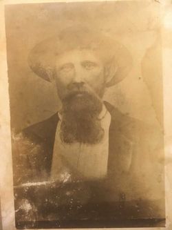
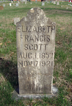
| Description | : | Daughter of Perlexton & Nancy Watson. Wife of Archie Arms, mother of Albert Lee Arms, Mary Jane Key, Lois A. Ashlock, and Elizabeth Frances Scott. Sister to William W. "Pusey Bill" Watson buried at Williams Cemetery on Pea Ridge, TN. I have searched the Rock Springs Church of Christ records and there have been numerous "Nancy Arms" in the history of Clay County and surrounding and the death entry for this Nancy Arms is closest to my ancestors time frame. |
frequently asked questions (FAQ):
-
Where is Nancy Watson Arms's memorial?
Nancy Watson Arms's memorial is located at: Rock Springs Cemetery, Celina, Clay County, USA.
-
When did Nancy Watson Arms death?
Nancy Watson Arms death on 10 Jul 1883 in Clay County, Tennessee, USA
-
Where are the coordinates of the Nancy Watson Arms's memorial?
Latitude: 36.6096992
Longitude: -85.4167023
Family Members:
Spouse
Children

Flowers:


Nearby Cemetories:
1. Rock Springs Cemetery
Celina, Clay County, USA
Coordinate: 36.6096992, -85.4167023
2. Thompson Webb Cemetery
Celina, Clay County, USA
Coordinate: 36.6090110, -85.4202270
3. Crossroads Cemetery
Clay County, USA
Coordinate: 36.6074982, -85.4210968
4. Williams Cemetery
Pea Ridge, Clay County, USA
Coordinate: 36.6150017, -85.4169006
5. Ashlock Cemetery
Ashlock, Cumberland County, USA
Coordinate: 36.6208380, -85.4283620
6. Hattie's Houses Cemetery
Pea Ridge, Clay County, USA
Coordinate: 36.6159200, -85.4360040
7. Mullins - Kerr Cemetery
Pea Ridge, Clay County, USA
Coordinate: 36.5951330, -85.4317470
8. Killman Cemetery
Ashlock, Cumberland County, USA
Coordinate: 36.6325850, -85.4256430
9. Donaldson Cemetery
Pea Ridge, Clay County, USA
Coordinate: 36.5952988, -85.4424973
10. Lester and Winnie Spears Cemetery
Burkesville, Cumberland County, USA
Coordinate: 36.6304420, -85.3829600
11. Bowe Cemetery
Pea Ridge, Clay County, USA
Coordinate: 36.5833015, -85.4439011
12. Smith Cemetery
Monroe County, USA
Coordinate: 36.6439881, -85.4203414
13. Key Cemetery
Pea Ridge, Clay County, USA
Coordinate: 36.5875015, -85.4518967
14. Grover Rich Cemetery
Pea Ridge, Clay County, USA
Coordinate: 36.5946370, -85.4602970
15. Dulworth Cemetery
Cumberland County, USA
Coordinate: 36.6292100, -85.3757900
16. Short's Chapel Cemetery
Monroe County, USA
Coordinate: 36.6281013, -85.4589005
17. Thompson Cemetery
Clay County, USA
Coordinate: 36.6123700, -85.4666600
18. Ray Williams Cemetery
Pea Ridge, Clay County, USA
Coordinate: 36.5856130, -85.4598120
19. Riley Cemetery
Littrell, Cumberland County, USA
Coordinate: 36.6509768, -85.3853975
20. Peyton Spear Cemetery
Peytonsburg, Cumberland County, USA
Coordinate: 36.6481590, -85.3778400
21. Capps-Key Cemetery
Burkesville, Cumberland County, USA
Coordinate: 36.6605280, -85.4129330
22. Pruitt Cemetery
Peytonsburg, Cumberland County, USA
Coordinate: 36.6571270, -85.3874590
23. Spears Chapel Cemetery
Peytonsburg, Cumberland County, USA
Coordinate: 36.6495790, -85.3714410
24. Poplar Grove Cemetery
Kettle, Cumberland County, USA
Coordinate: 36.6680090, -85.4074180