

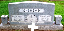
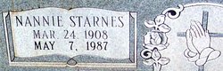
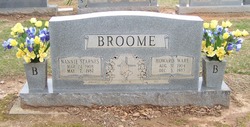
Nannie Ruth Starnes Broome
| Birth | : | 24 Mar 1908 Union County, North Carolina, USA |
| Death | : | 7 May 1987 Charlotte, Mecklenburg County, North Carolina, USA |
| Burial | : | St. Andrew's Churchyard, Billingborough, South Kesteven District, England |
| Coordinate | : | 52.8940140, -0.3397660 |
frequently asked questions (FAQ):
-
Where is Nannie Ruth Starnes Broome's memorial?
Nannie Ruth Starnes Broome's memorial is located at: St. Andrew's Churchyard, Billingborough, South Kesteven District, England.
-
When did Nannie Ruth Starnes Broome death?
Nannie Ruth Starnes Broome death on 7 May 1987 in Charlotte, Mecklenburg County, North Carolina, USA
-
Where are the coordinates of the Nannie Ruth Starnes Broome's memorial?
Latitude: 52.8940140
Longitude: -0.3397660
Family Members:
Parent

Spouse
Siblings
Children

Flowers:


Nearby Cemetories:
1. St. Andrew's Churchyard
Billingborough, South Kesteven District, England
Coordinate: 52.8940140, -0.3397660
2. Billingborough Cemetery
Billingborough, South Kesteven District, England
Coordinate: 52.8907700, -0.3497700
3. St Andrew Churchyard
Horbling, South Kesteven District, England
Coordinate: 52.9028460, -0.3380407
4. Sempringham Priory
Sempringham Fen, South Kesteven District, England
Coordinate: 52.8789250, -0.3583360
5. St Peter Church
Threekingham, North Kesteven District, England
Coordinate: 52.9116000, -0.3812000
6. St Andrew Churchyard
Folkingham, South Kesteven District, England
Coordinate: 52.8903840, -0.4092130
7. Aslackby Cemetery
Aslackby, South Kesteven District, England
Coordinate: 52.8597838, -0.3855002
8. St James the Great Churchyard
Aslackby, South Kesteven District, England
Coordinate: 52.8600900, -0.3894200
9. St Nicholas Churchyard
Walcot, North Kesteven District, England
Coordinate: 52.9035930, -0.4252890
10. St Peter & St Paul Churchyard
Osbournby, North Kesteven District, England
Coordinate: 52.9298800, -0.4105100
11. St. Andrew's Churchyard
Scredington, North Kesteven District, England
Coordinate: 52.9498300, -0.3701700
12. St Andrew's Churchyard
Rippingale, South Kesteven District, England
Coordinate: 52.8366700, -0.3718000
13. St Andrews Churchyard
Helpringham, North Kesteven District, England
Coordinate: 52.9519900, -0.3065200
14. St Andrew's Churchyard
Helpringham, North Kesteven District, England
Coordinate: 52.9521000, -0.3065000
15. St. Andrew Churchyard
Burton Pedwardine, North Kesteven District, England
Coordinate: 52.9646176, -0.3348618
16. St. Lucia Churchyard
Dembleby, North Kesteven District, England
Coordinate: 52.9268000, -0.4512300
17. St Thomas Churchyard
Aunsby, North Kesteven District, England
Coordinate: 52.9367820, -0.4470450
18. Great Hale New Cemetery
Great Hale, North Kesteven District, England
Coordinate: 52.9678690, -0.2940500
19. St Andrew's Churchyard
Haconby, South Kesteven District, England
Coordinate: 52.8135400, -0.3594300
20. Donington New Cemetery
Donington, South Holland District, England
Coordinate: 52.9071410, -0.2059100
21. Donington Old Cemetery
Donington, South Holland District, England
Coordinate: 52.9091670, -0.2055560
22. St. Mary and the Holy Rood Churchyard
Donington, South Holland District, England
Coordinate: 52.9072790, -0.2050080
23. St John the Baptist Churchyard
Great Hale, North Kesteven District, England
Coordinate: 52.9712140, -0.2914550
24. St Gilbert and St Hugh Churchyard
Gosberton Clough, South Holland District, England
Coordinate: 52.8518081, -0.2166268