| Birth | : | 26 Apr 1861 Indiana, USA |
| Death | : | 8 Nov 1928 Indianapolis, Marion County, Indiana, USA |
| Burial | : | Kawerau Cemetery, Kawerau, Kawerau District, New Zealand |
| Coordinate | : | -38.0990990, 176.6762150 |
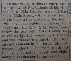
| Description | : | Nathaniel Quinn was the son of Mart Quinn and Mary McGuire. Husbando of Molly. He died of prostate cancer at 67 years of age. He was a horse man. (Death certificate) Item of Interest: "Nat Quinn will manage the Quinn racing horses this season. He will take out Sunrise, Violet L and one or two others." North Manchester Journal April 19, 1894 Nov. 12, 1928 North Manchester News Journal Nat Quinn died at the Robert Long hospital at Indianapolis Thursday night. He was taken there a few weeks ago for treatment, he... Read More |
frequently asked questions (FAQ):
-
Where is Nathaniel M. “Nat” Quinn's memorial?
Nathaniel M. “Nat” Quinn's memorial is located at: Kawerau Cemetery, Kawerau, Kawerau District, New Zealand.
-
When did Nathaniel M. “Nat” Quinn death?
Nathaniel M. “Nat” Quinn death on 8 Nov 1928 in Indianapolis, Marion County, Indiana, USA
-
Where are the coordinates of the Nathaniel M. “Nat” Quinn's memorial?
Latitude: -38.0990990
Longitude: 176.6762150
Family Members:
Parent
Spouse
Siblings
Children
Flowers:
Nearby Cemetories:
1. Kawerau Cemetery
Kawerau, Kawerau District, New Zealand
Coordinate: -38.0990990, 176.6762150
2. Matariu Urupā
Te Teko, Whakatāne District, New Zealand
Coordinate: -38.0390400, 176.8016400
3. Awakaponga Cemetery
Matatā, Whakatāne District, New Zealand
Coordinate: -37.9308200, 176.7465100
4. Punawhakareia Urupa
Rotoiti, Rotorua District, New Zealand
Coordinate: -38.0566969, 176.4451150
5. Ngāti Tarāwhai Ruatō urupa
Rotoiti, Rotorua District, New Zealand
Coordinate: -38.0578310, 176.4334750
6. Rangiaohia Māori Cemetery
Matatā, Whakatāne District, New Zealand
Coordinate: -37.8905100, 176.7639600
7. Ngahina Māori Cemetery
Ruatoki North, Whakatāne District, New Zealand
Coordinate: -38.1736200, 176.9892600
8. Ruatoki North Māori Cemetery
Ruatoki North, Whakatāne District, New Zealand
Coordinate: -38.1501100, 177.0073300
9. Pupuaruhe Urupā
Whakatāne, Whakatāne District, New Zealand
Coordinate: -37.9555600, 176.9624100
10. Okere Māori Cemetery
Okere Falls, Rotorua District, New Zealand
Coordinate: -38.0332900, 176.3464800
11. Motutawa Māori Cemetery
Mourea, Rotorua District, New Zealand
Coordinate: -38.0458300, 176.3381400
12. Domain Road Cemetery
Whakatāne, Whakatāne District, New Zealand
Coordinate: -37.9583600, 176.9840800
13. Hillcrest Cemetery
Whakatāne, Whakatāne District, New Zealand
Coordinate: -37.9673630, 177.0136840
14. Ōpihi Whanaunga Kore Urupā
Whakatāne, Whakatāne District, New Zealand
Coordinate: -37.9436107, 177.0046426
15. Rotorua Crematorium and Cemetery
Rotorua, Rotorua District, New Zealand
Coordinate: -38.1533100, 176.2630900
16. Whakarewarewa Urupā
Rotorua, Rotorua District, New Zealand
Coordinate: -38.1629708, 176.2556791
17. Murupara-Galatea Cemetery
Galatea, Whakatāne District, New Zealand
Coordinate: -38.4411700, 176.7164800
18. Te Papa Marae Māori Cemetery
Murupara, Whakatāne District, New Zealand
Coordinate: -38.4499600, 176.6989500
19. Puhirua Urupā
Ngongotaha, Rotorua District, New Zealand
Coordinate: -38.0433300, 176.2228820
20. Kauae Cemetery
Ngongotaha, Rotorua District, New Zealand
Coordinate: -38.0915298, 176.2152557
21. Waiteti (Weriwiri Pa) Cemetery
Ngongotaha, Rotorua District, New Zealand
Coordinate: -38.0689500, 176.2132000
22. Maketu Cemetery
Maketu, Western Bay of Plenty District, New Zealand
Coordinate: -37.7634700, 176.4511500
23. St. Thomas's Anglican Churchyard
Maketu, Western Bay of Plenty District, New Zealand
Coordinate: -37.7600849, 176.4555692
24. Ruamano Parekarangi Urupā
Horohoro, Rotorua District, New Zealand
Coordinate: -38.2349430, 176.1912227


