
| Birth | : | 1851 Pennsylvania, USA |
| Death | : | 9 Jan 1921 Great Falls, Cascade County, Montana, USA |
| Burial | : | Saint John The Baptist Churchyard, Denham, Mid Suffolk District, England |
| Coordinate | : | 52.3275300, 1.2101200 |
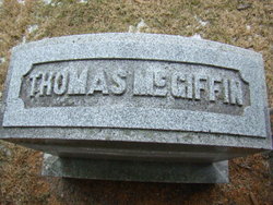
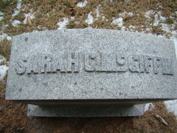
| Description | : | Note: Some family tree information on Nathaniel McGiffin use January 13, 1921 as his death date. While his obituary (shown pictured) was published on January 13, 1921 in Fairfield, Iowa, it refers to his death taking place the prior Sunday, which would be January 9th. Sometimes the obituary publication dates get used inadvertently as the death date, so family researchers should be aware of this discrepancy. --------- Son of Thomas McGiffin and Sarah Clark McGiffin. Born in Pennsylvania, possibly in the Washington county, Pennsylvania area where his father was born and raised. His parents were married in 1851;... Read More |
frequently asked questions (FAQ):
-
Where is Nathaniel McGiffin's memorial?
Nathaniel McGiffin's memorial is located at: Saint John The Baptist Churchyard, Denham, Mid Suffolk District, England.
-
When did Nathaniel McGiffin death?
Nathaniel McGiffin death on 9 Jan 1921 in Great Falls, Cascade County, Montana, USA
-
Where are the coordinates of the Nathaniel McGiffin's memorial?
Latitude: 52.3275300
Longitude: 1.2101200
Family Members:
Parent
Spouse
Siblings

Children
Flowers:


Nearby Cemetories:
1. Saint John The Baptist Churchyard
Denham, Mid Suffolk District, England
Coordinate: 52.3275300, 1.2101200
2. Saint Peter and St. Paul Churchyard
Hoxne, Mid Suffolk District, England
Coordinate: 52.3522270, 1.2016300
3. St Mary Churchyard
Horham, Mid Suffolk District, England
Coordinate: 52.3056620, 1.2408640
4. St. Nicholas Churchyard
Oakley, Mid Suffolk District, England
Coordinate: 52.3518380, 1.1662190
5. Saint Peter and Saint Paul Churchyard
Eye, Mid Suffolk District, England
Coordinate: 52.3200520, 1.1516450
6. St. Andrew's Church
Redlingfield, Mid Suffolk District, England
Coordinate: 52.2910750, 1.2046550
7. St. Peter's Churchyard
Athelington, Mid Suffolk District, England
Coordinate: 52.2924920, 1.2397060
8. Eye War Memorial
Eye, Mid Suffolk District, England
Coordinate: 52.3213410, 1.1461480
9. All Saints Churchyard
Stradbroke, Mid Suffolk District, England
Coordinate: 52.3186110, 1.2733720
10. St. Margaret's Churchyard
Syleham, Mid Suffolk District, England
Coordinate: 52.3641870, 1.2372060
11. Horham Baptist Church
Horham, Mid Suffolk District, England
Coordinate: 52.2965910, 1.2536000
12. St. Mary's Churchyard
Brome, Mid Suffolk District, England
Coordinate: 52.3443800, 1.1475990
13. St Leonard Churchyard
Billingford, South Norfolk District, England
Coordinate: 52.3666290, 1.1834260
14. Eye Cemetery
Eye, Mid Suffolk District, England
Coordinate: 52.3188270, 1.1371000
15. Stradbroke Cemetery
Stradbroke, Mid Suffolk District, England
Coordinate: 52.3187700, 1.2831900
16. St. Michael's Churchyard
Occold, Mid Suffolk District, England
Coordinate: 52.2936170, 1.1598150
17. St. Peter and St. Paul Churchyard
Brockdish, South Norfolk District, England
Coordinate: 52.3705240, 1.2366100
18. Saint Andrew Churchyard
Scole, South Norfolk District, England
Coordinate: 52.3671670, 1.1579150
19. Southolt War Memorial
Southolt, Mid Suffolk District, England
Coordinate: 52.2740910, 1.2137880
20. St Margaret's Churchyard
Southolt, Mid Suffolk District, England
Coordinate: 52.2740770, 1.2136110
21. St Mary Churchyard
Bedingfield, Mid Suffolk District, England
Coordinate: 52.2740440, 1.1937880
22. All Saints Churchyard
Stuston, Mid Suffolk District, England
Coordinate: 52.3571980, 1.1332590
23. St Mary's Church Burial Ground - old
Braiseworth, Mid Suffolk District, England
Coordinate: 52.3028860, 1.1277010
24. Braiseworth War Memorial
Braiseworth, Mid Suffolk District, England
Coordinate: 52.3027890, 1.1276970