
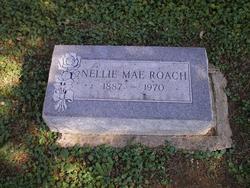
Nellie Mae Lear Roach
| Birth | : | 4 Oct 1887 Burlingame Township, Osage County, Kansas, USA |
| Death | : | 1970 |
| Burial | : | Lovell Lake Cemetery, Sanbornville, Carroll County, USA |
| Coordinate | : | 43.5506000, -71.0244000 |
| Plot | : | Section 1, Lot 178 |
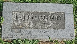
| Description | : | Nellie married Ralph Bryan Montgomery on May 23, 1907, at her parents’ home in Burlingame Township. |
frequently asked questions (FAQ):
-
Where is Nellie Mae Lear Roach's memorial?
Nellie Mae Lear Roach's memorial is located at: Lovell Lake Cemetery, Sanbornville, Carroll County, USA.
-
When did Nellie Mae Lear Roach death?
Nellie Mae Lear Roach death on 1970 in
-
Where are the coordinates of the Nellie Mae Lear Roach's memorial?
Latitude: 43.5506000
Longitude: -71.0244000
Family Members:
Parent
Spouse
Siblings
Children
Flowers:


Nearby Cemetories:
1. Hutchins Cemetery
Wakefield, Carroll County, USA
Coordinate: 43.5481000, -71.0330000
2. Saint Anthonys Cemetery
Sanbornville, Carroll County, USA
Coordinate: 43.5494500, -71.0386710
3. Hutchins Brackett Farm Cemetery
Sanbornville, Carroll County, USA
Coordinate: 43.5573807, -71.0097885
4. Sanborn Cemetery 35
Wakefield, Carroll County, USA
Coordinate: 43.5656189, -71.0039812
5. Historic Wakefield Corner Burial Ground
Wakefield, Carroll County, USA
Coordinate: 43.5719719, -71.0258713
6. Gilman Cemetery
Wakefield, Carroll County, USA
Coordinate: 43.5316670, -71.0383330
7. Ferguson-Chamberlain Cemetery
Brookfield, Carroll County, USA
Coordinate: 43.5327000, -71.0408000
8. Dealand Cemetery
Brookfield, Carroll County, USA
Coordinate: 43.5452510, -71.0532190
9. Clark Cemetery
Brookfield, Carroll County, USA
Coordinate: 43.5274710, -71.0299160
10. Belknap Cemetery
Brookfield, Carroll County, USA
Coordinate: 43.5361050, -71.0515020
11. Cate Cemetery
Brookfield, Carroll County, USA
Coordinate: 43.5382200, -71.0545920
12. Wentworth-Garvin Cemetery
Wakefield, Carroll County, USA
Coordinate: 43.5680560, -70.9983330
13. Buzzell Cemetery
Brookfield, Carroll County, USA
Coordinate: 43.5395890, -71.0571670
14. Gage Hill Cemetery
Wakefield, Carroll County, USA
Coordinate: 43.5743900, -71.0408300
15. Churchill Family Cemetery
Brookfield, Carroll County, USA
Coordinate: 43.5494000, -71.0625000
16. Churchill Cemetery
Brookfield, Carroll County, USA
Coordinate: 43.5476000, -71.0650000
17. Pike Cemetery
Brookfield, Carroll County, USA
Coordinate: 43.5735220, -71.0515990
18. Hutchins Family Cemetery
Sanbornville, Carroll County, USA
Coordinate: 43.5319366, -70.9909897
19. Pike Cemetery
Brookfield, Carroll County, USA
Coordinate: 43.5318500, -70.9910667
20. Garland Family Cemetery
Wakefield, Carroll County, USA
Coordinate: 43.5313000, -70.9902000
21. Dodavah Copp Burial Site
Wakefield, Carroll County, USA
Coordinate: 43.5767308, -70.9995894
22. Allen Cemetery
Wakefield, Carroll County, USA
Coordinate: 43.5185300, -71.0269400
23. Dow Cemetery
Wakefield, Carroll County, USA
Coordinate: 43.5825000, -71.0150000
24. Robinson Cemetery
Brookfield, Carroll County, USA
Coordinate: 43.5694000, -71.0645000