
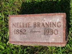
Nellie Pauline Hunt Braning
| Birth | : | 14 Jun 1882 Sprott, Ste. Genevieve County, Missouri, USA |
| Death | : | 2 May 1930 Bonne Terre, St. Francois County, Missouri, USA |
| Burial | : | Oakwood Cemetery, Stratford, Hamilton County, USA |
| Coordinate | : | 42.2942009, -93.9182968 |
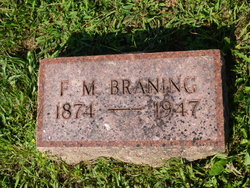
| Description | : | Unknown St. Francois Co. Newspaper (May 1930) Mrs. Nellie Pauline Braning was the daughter of L.T. and Martha (nee Turley) Hunt and was born in Ste. Genevieve Co., Mo. on June 14, 1882. She was married to Fred M. Braning on Aug. 25th, 1902. To this union one son was born, Lehman Braning of Bonne Terre, Mo. She died in the Bonne Terre Hospital on May 2, 1930 at 3:40 p.m. from injuries received in an auto accident. Mrs. Braning was a member of the Baptist church since her childhood and remained a devoted member until her death. She was 48 years 3 months,... Read More |
frequently asked questions (FAQ):
-
Where is Nellie Pauline Hunt Braning's memorial?
Nellie Pauline Hunt Braning's memorial is located at: Oakwood Cemetery, Stratford, Hamilton County, USA.
-
When did Nellie Pauline Hunt Braning death?
Nellie Pauline Hunt Braning death on 2 May 1930 in Bonne Terre, St. Francois County, Missouri, USA
-
Where are the coordinates of the Nellie Pauline Hunt Braning's memorial?
Latitude: 42.2942009
Longitude: -93.9182968
Family Members:
Spouse
Children
Flowers:


Nearby Cemetories:
1. Oakwood Cemetery
Stratford, Hamilton County, USA
Coordinate: 42.2942009, -93.9182968
2. Hooks Point Cemetery
Hamilton County, USA
Coordinate: 42.2944530, -93.9199090
3. Vegors Cemetery
Webster County, USA
Coordinate: 42.3177986, -93.9421997
4. Neese Cemetery
Homer, Hamilton County, USA
Coordinate: 42.3250000, -93.8935000
5. Nesse Cemetery
Hamilton County, USA
Coordinate: 42.3250008, -93.8933029
6. Hardin Township Cemetery
Hardin Township, Webster County, USA
Coordinate: 42.2411003, -93.9708023
7. McGuire Bend Cemetery
Dayton, Webster County, USA
Coordinate: 42.3410000, -93.9880000
8. South Marion Cemetery
Stratford, Hamilton County, USA
Coordinate: 42.2327995, -93.8735962
9. Bass Cemetery
Dayton, Webster County, USA
Coordinate: 42.2966995, -94.0149994
10. Homer Cemetery
Homer, Hamilton County, USA
Coordinate: 42.3680992, -93.9088974
11. Hartman Cemetery
Lehigh, Webster County, USA
Coordinate: 42.3666397, -93.9835627
12. Saratoga Cemetery
Stanhope, Hamilton County, USA
Coordinate: 42.3539009, -93.8167038
13. Linn Cemetery
Pilot Mound, Boone County, USA
Coordinate: 42.2045330, -93.9970230
14. Ober and Scott Cemetery
Duncombe, Webster County, USA
Coordinate: 42.3841390, -93.9982856
15. Oak Grove Cemetery
Lehigh, Webster County, USA
Coordinate: 42.3438988, -94.0475006
16. Christ the King Catholic Cemetery
Dayton, Webster County, USA
Coordinate: 42.2601929, -94.0727539
17. Lawn Hill Cemetery
Stanhope, Hamilton County, USA
Coordinate: 42.2677994, -93.7611008
18. Dayton Cemetery
Dayton, Webster County, USA
Coordinate: 42.2675000, -94.0755000
19. Mineral Ridge Cemetery
Ridgeport, Boone County, USA
Coordinate: 42.1749992, -93.9266968
20. White Cemetery
Boone County, USA
Coordinate: 42.1777992, -93.9636002
21. Blanchard Cemetery
Webster County, USA
Coordinate: 42.4021988, -93.9997025
22. Lake Center Cemetery
Stanhope, Hamilton County, USA
Coordinate: 42.2482986, -93.7568970
23. West Lawn Cemetery
Lehigh, Webster County, USA
Coordinate: 42.3616982, -94.0678024
24. Zion Cemetery
Kamrar, Hamilton County, USA
Coordinate: 42.3544006, -93.7572021