

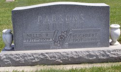
Nellie R. Smith Parsons
| Birth | : | 4 Mar 1917 Cozad, Dawson County, Nebraska, USA |
| Death | : | 31 Oct 2009 Cozad, Dawson County, Nebraska, USA |
| Burial | : | Mangere Lawn Cemetery, Mangere, Auckland Council, New Zealand |
| Coordinate | : | -36.9626150, 174.7857000 |
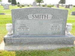
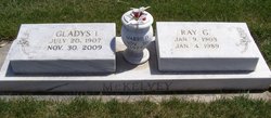
| Description | : | Nellie R. Parsons, departed this life and entered The Eternal Home on October 31, 2009, at her home in The Golden Living Care Center in Cozad, Nebraska. Nellie was 92 years of age having been born on March 4, 1917 in Cozad, Nebraska to Israel and Mary (Woodside) Smith. Nellie attended District 26 rural school northeast of Cozad, Nebraska . On April 8, 1936, she married Hughbert Parsons at Cozad, Nebraska. The couple made their home on a farm site east of Cozad, Nebraska in Dawson County.. Nellie and Hughbert lived in the Cozad area their entire married life. Mr.... Read More |
frequently asked questions (FAQ):
-
Where is Nellie R. Smith Parsons's memorial?
Nellie R. Smith Parsons's memorial is located at: Mangere Lawn Cemetery, Mangere, Auckland Council, New Zealand.
-
When did Nellie R. Smith Parsons death?
Nellie R. Smith Parsons death on 31 Oct 2009 in Cozad, Dawson County, Nebraska, USA
-
Where are the coordinates of the Nellie R. Smith Parsons's memorial?
Latitude: -36.9626150
Longitude: 174.7857000
Family Members:
Parent

Spouse
Siblings
Flowers:


Nearby Cemetories:
1. Mangere Lawn Cemetery
Mangere, Auckland Council, New Zealand
Coordinate: -36.9626150, 174.7857000
2. Mangere Presbyterian Cemetery
Mangere, Auckland Council, New Zealand
Coordinate: -36.9750197, 174.7924783
3. Mangere Piriti Urupā St. James Churchyard
Mangere, Auckland Council, New Zealand
Coordinate: -36.9418970, 174.7835260
4. Waikaraka Cemetery
Ōnehunga, Auckland Council, New Zealand
Coordinate: -36.9297140, 174.7967170
5. St. Peter's Anglican Cemetery
Ōnehunga, Auckland Council, New Zealand
Coordinate: -36.9227113, 174.7847550
6. Onehunga Catholic Cemetery
Ōnehunga, Auckland Council, New Zealand
Coordinate: -36.9224360, 174.7884560
7. Our Lady of the Assumption Catholic Church
Ōnehunga, Auckland Council, New Zealand
Coordinate: -36.9223690, 174.7884530
8. Hillsborough Cemetery
Hillsborough, Auckland Council, New Zealand
Coordinate: -36.9246600, 174.7524030
9. Nixon Memorial
Ōtāhūhū, Auckland Council, New Zealand
Coordinate: -36.9499366, 174.8449909
10. Papatoetoe Cemetery
Papatoetoe, Auckland Council, New Zealand
Coordinate: -36.9893110, 174.8373530
11. Otahuhu Public Cemetery
Ōtāhūhū, Auckland Council, New Zealand
Coordinate: -36.9377500, 174.8432390
12. Holy Trinity Memorial Park
Ōtāhūhū, Auckland Council, New Zealand
Coordinate: -36.9374510, 174.8448580
13. Manukau Memorial Gardens
Manukau, Auckland Council, New Zealand
Coordinate: -36.9944380, 174.8397300
14. St. Joseph and St. Joachim Catholic Cemetery
Ōtāhūhū, Auckland Council, New Zealand
Coordinate: -36.9436100, 174.8490100
15. St. John's Presbyterian Church Cemetery
Papatoetoe, Auckland Council, New Zealand
Coordinate: -36.9674185, 174.8598178
16. Saint Andrew's Churchyard
Epsom, Auckland Council, New Zealand
Coordinate: -36.8937200, 174.7654100
17. St Matthias Churchyard
Panmure, Auckland Council, New Zealand
Coordinate: -36.9053300, 174.8577200
18. St. Patrick's Roman Catholic Church Cemetery
Panmure, Auckland Council, New Zealand
Coordinate: -36.9029680, 174.8564960
19. Woodside Methodist Cemetery
Manukau, Auckland Council, New Zealand
Coordinate: -36.9929680, 174.8837860
20. St. John's Church Cemetery
East Tamaki, Auckland Council, New Zealand
Coordinate: -36.9522250, 174.8964540
21. St Mark's Anglican Church Cemetery
Remuera, Auckland Council, New Zealand
Coordinate: -36.8729300, 174.7801600
22. St. David's Anglican Churchyard
Wiri, Auckland Council, New Zealand
Coordinate: -37.0025400, 174.8886150
23. Saint Ninians Churchyard
Avondale, Auckland Council, New Zealand
Coordinate: -36.8994510, 174.6966690
24. St. Luke's Anglican Church Cemetery
Mount Albert, Auckland Council, New Zealand
Coordinate: -36.8785540, 174.7290400