
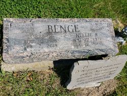
Nellie Ruth Thompson Benge
| Birth | : | 22 Aug 1917 Davis County, Iowa, USA |
| Death | : | 19 Dec 2008 Davis County, Iowa, USA |
| Burial | : | Saint Francis Xavier Cemetery, Renfrew, Renfrew County, Canada |
| Coordinate | : | 45.4872100, -76.6921600 |
| Description | : | BLOOMFIELD — Nellie Ruth Benge, 91, of 26477 Quake Avenue Bloomfield, died Dec. 19, 2008, at her home. She was born Aug. 22, 1917 in Floris to John Samuel and Flora May Davis Thompson.She married Loran R. Benge June 1, 1938 in Kirksville, Mo. She graduated from Bloomfield High School in 1935 and later from Drake University. She taught for 30 years in rural schools and for Davis County Community Schools. She was a member of the Davis County Retired School Teachers and a lifetime member of the Iowa Retired Teachers. She was a member of the Moulton Christian Church.... Read More |
frequently asked questions (FAQ):
-
Where is Nellie Ruth Thompson Benge's memorial?
Nellie Ruth Thompson Benge's memorial is located at: Saint Francis Xavier Cemetery, Renfrew, Renfrew County, Canada.
-
When did Nellie Ruth Thompson Benge death?
Nellie Ruth Thompson Benge death on 19 Dec 2008 in Davis County, Iowa, USA
-
Where are the coordinates of the Nellie Ruth Thompson Benge's memorial?
Latitude: 45.4872100
Longitude: -76.6921600
Family Members:
Flowers:


Nearby Cemetories:
1. Saint Francis Xavier Cemetery
Renfrew, Renfrew County, Canada
Coordinate: 45.4872100, -76.6921600
2. North Horton Cemetery
Renfrew, Renfrew County, Canada
Coordinate: 45.5177800, -76.6718355
3. Thompson Hill Cemetery
Thompson Hill, Renfrew County, Canada
Coordinate: 45.4567900, -76.6710200
4. McLaren Cemetery
Renfrew, Renfrew County, Canada
Coordinate: 45.4553800, -76.6632200
5. Costello Cemetery
Horton, Renfrew County, Canada
Coordinate: 45.4684307, -76.6346983
6. Old Martin Cemetery
Horton, Renfrew County, Canada
Coordinate: 45.4673350, -76.6318680
7. Admaston Cemetery
Admaston, Renfrew County, Canada
Coordinate: 45.4568750, -76.7694830
8. Rosebank Cemetery
Rosebank, Renfrew County, Canada
Coordinate: 45.5251000, -76.7829110
9. Goshen Public Cemetery
Goshen, Renfrew County, Canada
Coordinate: 45.4377130, -76.5794520
10. Fraser Cemetery
Burnstown, Renfrew County, Canada
Coordinate: 45.3903130, -76.6384360
11. St. George Anglican Church Cemetery
Portage-du-Fort, Outaouais Region, Canada
Coordinate: 45.5934170, -76.6678210
12. Protestant Cemetery of Portage du Fort
Portage-du-Fort, Outaouais Region, Canada
Coordinate: 45.5926410, -76.6584030
13. St. James Roman Catholic Cemetery
Portage-du-Fort, Outaouais Region, Canada
Coordinate: 45.5929000, -76.6582800
14. Haley Cemetery
Haley Station, Renfrew County, Canada
Coordinate: 45.5722300, -76.7880700
15. Castleford Union Cemetery
Castleford, Renfrew County, Canada
Coordinate: 45.5100900, -76.5395200
16. Austin United Cemetery
Clarendon Front, Outaouais Region, Canada
Coordinate: 45.5589610, -76.5529840
17. St. James the Greater Cemetery
Portage-du-Fort, Outaouais Region, Canada
Coordinate: 45.6091700, -76.6508400
18. Springtown Protestant Cemetery
Springtown, Renfrew County, Canada
Coordinate: 45.3540590, -76.6487820
19. Saint Gabriel's Roman Catholic Cemetery
Springtown, Renfrew County, Canada
Coordinate: 45.3468860, -76.6621210
20. Old Clarendon Cemetery
Clarendon, Outaouais Region, Canada
Coordinate: 45.5342450, -76.5005850
21. Litchfield United Cemetery
Outaouais Region, Canada
Coordinate: 45.6309030, -76.6564860
22. Gillies Family Cemetery
Braeside, Renfrew County, Canada
Coordinate: 45.4168100, -76.4994000
23. Saint Andrew's Presbyterian Cemetery
Kerr Line, Renfrew County, Canada
Coordinate: 45.6479200, -76.7433600
24. Saint John's Anglican Cemetery
Lawn, Outaouais Region, Canada
Coordinate: 45.6314990, -76.5780040