

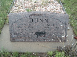
Nettie Mildred Sours Dunn
| Birth | : | 19 May 1913 |
| Death | : | 16 Dec 2003 |
| Burial | : | Union Divide Creek Cemetery, Silt, Garfield County, USA |
| Coordinate | : | 39.4508018, -107.6200027 |
| Description | : | Nettie Mildred Dunn died Tuesday, Dec. 16, 2003, at Mesa Vista Assisted Living in Parachute. She was 90. A memorial service will be held at 1:30 p.m. Friday, Jan. 2, at First Christian Church in Rifle with the Rev. Dene Johnson officiating. Mrs. Dunn was born May 19, 1913, in Mattoon, Ill., to Charles Paul and Alta Foss (Nelson) Sours. She married Harold Dunn on Oct. 19, 1929, in Glenwood Springs. She was a rancher and homemaker, and lived her entire life in Colorado. She was a member of Fairview Congregational Church on Divide Creek, and later First Christian Church in Rifle. She also belonged to... Read More |
frequently asked questions (FAQ):
-
Where is Nettie Mildred Sours Dunn's memorial?
Nettie Mildred Sours Dunn's memorial is located at: Union Divide Creek Cemetery, Silt, Garfield County, USA.
-
When did Nettie Mildred Sours Dunn death?
Nettie Mildred Sours Dunn death on 16 Dec 2003 in
-
Where are the coordinates of the Nettie Mildred Sours Dunn's memorial?
Latitude: 39.4508018
Longitude: -107.6200027
Family Members:
Parent

Spouse
Siblings
Flowers:


Nearby Cemetories:
1. Union Divide Creek Cemetery
Silt, Garfield County, USA
Coordinate: 39.4508018, -107.6200027
2. Skyline Cemetery
Silt, Garfield County, USA
Coordinate: 39.5520060, -107.6575300
3. Rose Hill Cemetery
Rifle, Garfield County, USA
Coordinate: 39.5381012, -107.7742004
4. Highland Cemetery
New Castle, Garfield County, USA
Coordinate: 39.5875015, -107.5192032
5. Rosebud Cemetery
Glenwood Springs, Garfield County, USA
Coordinate: 39.5168991, -107.3189011
6. Farnum Holt Columbarium
Glenwood Springs, Garfield County, USA
Coordinate: 39.5469640, -107.3299900
7. Rulison Cemetery
Rulison, Garfield County, USA
Coordinate: 39.4768000, -107.9357000
8. Pioneer Cemetery
Glenwood Springs, Garfield County, USA
Coordinate: 39.5392000, -107.3192000
9. Marion Cemetery
Garfield County, USA
Coordinate: 39.3689003, -107.3047028
10. Blackman Ranch Cemetery
Collbran, Mesa County, USA
Coordinate: 39.2647420, -107.8554350
11. Clover Cemetery
Collbran, Mesa County, USA
Coordinate: 39.2550011, -107.9227982
12. Evergreen Cemetery
Carbondale, Garfield County, USA
Coordinate: 39.4077988, -107.2155991
13. Battlement Cemetery
Parachute, Garfield County, USA
Coordinate: 39.4380989, -108.0291977
14. Fisher Cemetery
Carbondale, Garfield County, USA
Coordinate: 39.4791985, -107.1911011
15. Hillcrest Cemetery
Carbondale, Garfield County, USA
Coordinate: 39.3922005, -107.1936035
16. Russey-Hurlburt Cemetery
Parachute, Garfield County, USA
Coordinate: 39.4522018, -108.0575027
17. Cedar Crest Cemetery
Collbran, Mesa County, USA
Coordinate: 39.2369003, -107.9589005
18. Eagalite Cemetery
Plateau City, Mesa County, USA
Coordinate: 39.2228012, -107.9894028
19. Hillside Cemetery
Redstone, Pitkin County, USA
Coordinate: 39.1843300, -107.2418900
20. Molina Cemetery
Molina, Mesa County, USA
Coordinate: 39.1886000, -108.0629000
21. Prospect Mountain Ranch Cemetery
Marble, Gunnison County, USA
Coordinate: 39.0927230, -107.2395980
22. Dotsero Cemetery
Dotsero, Eagle County, USA
Coordinate: 39.6477600, -107.0672200
23. Basalt Cemetery
Basalt, Eagle County, USA
Coordinate: 39.3646800, -107.0213100
24. DeBeque Cemetery
Mesa County, USA
Coordinate: 39.3374060, -108.2138900