
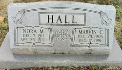
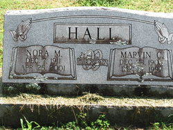
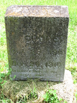
Nora M. Cooper Hall
| Birth | : | 7 Dec 1911 Powell, McDonald County, Missouri, USA |
| Death | : | 25 Apr 2001 Anadarko, Caddo County, Oklahoma, USA |
| Burial | : | Forest Lawn Cemetery, Creston, Central Kootenay Regional District, Canada |
| Coordinate | : | 49.0991400, -116.4626400 |
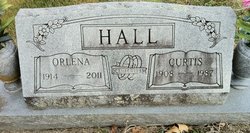
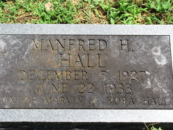
| Description | : | Wife of Marvin C. Hall married March 26, 1927 in Powell, Mo. Marvin died Dec. 17, 1991. Mother of Avan, Ervin, & Manford Hall; Sister of Alvin, Hazel (Cooper) Beaver, Lena (Cooper) Hall, & Emma (Cooper) Hendrickson. Nora moved to Oklahoma in 1987 from Boulder City, Mo. She was a homemaker and enjoyed gardening & raising chickens. She was of the Baptist Faith. |
frequently asked questions (FAQ):
-
Where is Nora M. Cooper Hall's memorial?
Nora M. Cooper Hall's memorial is located at: Forest Lawn Cemetery, Creston, Central Kootenay Regional District, Canada.
-
When did Nora M. Cooper Hall death?
Nora M. Cooper Hall death on 25 Apr 2001 in Anadarko, Caddo County, Oklahoma, USA
-
Where are the coordinates of the Nora M. Cooper Hall's memorial?
Latitude: 49.0991400
Longitude: -116.4626400
Family Members:
Parent

Spouse
Siblings
Children


Nearby Cemetories:
1. Forest Lawn Cemetery
Creston, Central Kootenay Regional District, Canada
Coordinate: 49.0991400, -116.4626400
2. Pioneer Cemetery
Creston, Central Kootenay Regional District, Canada
Coordinate: 49.0921800, -116.5127700
3. St. Peter's Cemetery
Creston, Central Kootenay Regional District, Canada
Coordinate: 49.0617730, -116.5173680
4. Lister Community Cemetery
Lister, Central Kootenay Regional District, Canada
Coordinate: 49.0466400, -116.4690100
5. Lister All Saints Anglican Church Cemetery
Lister, Central Kootenay Regional District, Canada
Coordinate: 49.0441667, -116.4691667
6. Goat River Cemetery
Creston, Central Kootenay Regional District, Canada
Coordinate: 49.1411200, -116.3992060
7. Porthill Cemetery
Porthill, Boundary County, USA
Coordinate: 48.9994000, -116.4840000
8. Copeland Cemetery
Copeland, Boundary County, USA
Coordinate: 48.9202995, -116.3783035
9. Yahk Cemetery
Yahk, Central Kootenay Regional District, Canada
Coordinate: 49.0885510, -116.0776230
10. Mountain View Mennonite Cemetery
Bonners Ferry, Boundary County, USA
Coordinate: 48.7389000, -116.2968000
11. Saint Michaels Mission Cemetery
Boundary County, USA
Coordinate: 48.7080700, -116.3684000
12. Boswell Cemetery
Boswell, Central Kootenay Regional District, Canada
Coordinate: 49.4552000, -116.7615000
13. Woodland Mennonite Church Cemetery
Bonners Ferry, Boundary County, USA
Coordinate: 48.7010470, -116.3335570
14. Grandview Cemetery
Bonners Ferry, Boundary County, USA
Coordinate: 48.6851300, -116.2932700
15. Moravia Cemetery
Moravia, Boundary County, USA
Coordinate: 48.6591988, -116.3741989
16. Moyie Cemetery
Moyie, East Kootenay Regional District, Canada
Coordinate: 49.2743920, -115.8350350
17. Parker Family Cemetery
Boundary County, USA
Coordinate: 48.6665200, -116.2619200
18. Paradise Valley Cemetery
Bonners Ferry, Boundary County, USA
Coordinate: 48.6453018, -116.3080978
19. Holy Myrrhbearers Orthodox Church Parish Cemetery
Bonners Ferry, Boundary County, USA
Coordinate: 48.6190260, -116.3598830
20. Ymir Cemetery
Ymir, Central Kootenay Regional District, Canada
Coordinate: 49.2815230, -117.2055080
21. Salmo Doukhobor Cemetery
Salmo, Central Kootenay Regional District, Canada
Coordinate: 49.2307400, -117.2521700
22. Sylvanite Cemetery
Lincoln County, USA
Coordinate: 48.7210000, -115.8745000
23. Hearn's Hill Mitsunaga Gravesite
Salmo, Central Kootenay Regional District, Canada
Coordinate: 49.1979900, -117.2808600
24. Boulder Creek Cemetery
Boundary County, USA
Coordinate: 48.6194000, -116.0571976