
| Birth | : | 1 Oct 1941 Montgomery County, Iowa, USA |
| Death | : | 28 Jul 1995 Council Bluffs, Pottawattamie County, Iowa, USA |
| Burial | : | Hillside Cemetery, Elliott, Montgomery County, USA |
| Coordinate | : | 41.1408005, -95.1544037 |
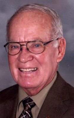
| Description | : | Norma Jean McCunn, daughter of John Hershel McCunn and Greta May Abbott, was born October 1, 1941 in Montgomery County, Iowa. She married Richard Delaine Peterson on on Sept. 24, 1960. They are the parents of four children, Kimberly Dawn (1961), Robert Delaine (1967), John Maurice (1970), and Nicole Rae (1971). Richard is a partner in a Phillips 66 Oil business in Elliott. She died July 28, 1995 in the Mercy Hospital in Council Bluffs, Iowa of ASHD, Scott Blair M. D. Council Bluffs. She was buried in the Hillside Cemetery, Elliott. Nelson Boylan Funeral Home. |
frequently asked questions (FAQ):
-
Where is Norma Jean McCunn Peterson's memorial?
Norma Jean McCunn Peterson's memorial is located at: Hillside Cemetery, Elliott, Montgomery County, USA.
-
When did Norma Jean McCunn Peterson death?
Norma Jean McCunn Peterson death on 28 Jul 1995 in Council Bluffs, Pottawattamie County, Iowa, USA
-
Where are the coordinates of the Norma Jean McCunn Peterson's memorial?
Latitude: 41.1408005
Longitude: -95.1544037
Family Members:
Parent
Spouse

Siblings

Flowers:


Nearby Cemetories:
1. Hillside Cemetery
Elliott, Montgomery County, USA
Coordinate: 41.1408005, -95.1544037
2. Mercer Cemetery
Pottawattamie County, USA
Coordinate: 41.1753006, -95.1650009
3. Waveland Cemetery
Pottawattamie County, USA
Coordinate: 41.1738700, -95.1881500
4. Pilot Grove Center Cemetery
Elliott, Montgomery County, USA
Coordinate: 41.1190600, -95.0993700
5. Indian Graveyard
Sherman Township, Montgomery County, USA
Coordinate: 41.0955730, -95.1837580
6. Lowman Cemetery
Griswold, Cass County, USA
Coordinate: 41.1594009, -95.0886002
7. Pleasant Township Cemetery
Griswold, Cass County, USA
Coordinate: 41.2056000, -95.1370000
8. Haefflick Burial Site
Red Oak, Montgomery County, USA
Coordinate: 41.0726300, -95.1561700
9. L Laire Property Cemetery (Defunct)
Sherman Township, Montgomery County, USA
Coordinate: 41.0958257, -95.2224927
10. Pilot Grove Presbyterian Cemetery
Wallin, Montgomery County, USA
Coordinate: 41.0793991, -95.0699997
11. Saint Clair Cemetery
Red Oak Township, Montgomery County, USA
Coordinate: 41.0598400, -95.2049810
12. Flint Cemetery
Pottawattamie County, USA
Coordinate: 41.2289009, -95.1841965
13. Center Ridge Cemetery
Montgomery County, USA
Coordinate: 41.1452141, -95.2787018
14. Griswold Cemetery
Waveland Township, Pottawattamie County, USA
Coordinate: 41.2360992, -95.1735992
15. Saint Marys Cemetery
Red Oak, Montgomery County, USA
Coordinate: 41.0447006, -95.2275009
16. Tabor Cemetery
Wallin, Montgomery County, USA
Coordinate: 41.0543700, -95.0619900
17. Frankfort Cemetery
Montgomery County, USA
Coordinate: 41.0271988, -95.1327972
18. Gomer Cemetery
Wales, Montgomery County, USA
Coordinate: 41.1171989, -95.3082962
19. Smith Cemetery
Griswold, Cass County, USA
Coordinate: 41.2606010, -95.1453018
20. Grant Cemetery
Grant, Montgomery County, USA
Coordinate: 41.1405983, -94.9906006
21. Mortons Mill Cemetery
Morton Mills, Montgomery County, USA
Coordinate: 41.0793991, -95.0085983
22. Evergreen Cemetery
Red Oak, Montgomery County, USA
Coordinate: 41.0228004, -95.2205963
23. Old East Cemetery
Grant, Montgomery County, USA
Coordinate: 41.1444016, -94.9792023
24. Douglas Township Cemetery
Grant, Montgomery County, USA
Coordinate: 41.1360933, -94.9752558