

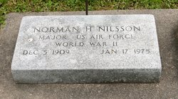
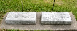
Norman Harold Nilsson
| Birth | : | 5 Dec 1909 Wisconsin, USA |
| Death | : | 17 Jan 1975 Cook County, Illinois, USA |
| Burial | : | Elkader Cemetery, Elkader, Clayton County, USA |
| Coordinate | : | 42.8541718, -91.4000015 |
| Description | : | Name: Norman Harold Nilsson Event Type: Death Event Date: 17 Jan 1975 Event Place: Proviso Township, Cook, Illinois, United States Address: 401 Briar Gender: Male Age: 65 Marital Status: Married Race: White Occupation: Telephone Installer Birth Date: 05 Dec 1909 Birthplace: , , Wisconsin Funeral Home: McMurrough Chaples Burial Date: 22 Jan 1975 Burial Place: Elkader, , Iowa Cemetery: East Side Cemetery Father's Name: Otto E Nilsson Mother's Name: Margaret Bull Spouse's Name: Francis Turner Informant's Name: Francis Turner Nilsson Citing this Record: "Illinois, Cook County Deaths, 1878-1994," database, FamilySearch (https://familysearch.org/ark:/61903/1:1:Q2MN-XJDW : 17 May 2016), Norman Harold Nilsson, 17 Jan 1975; citing Proviso Township, Cook, Illinois, United States, source reference , record number , Cook County Courthouse, Chicago; FHL microfilm . |
frequently asked questions (FAQ):
-
Where is Norman Harold Nilsson's memorial?
Norman Harold Nilsson's memorial is located at: Elkader Cemetery, Elkader, Clayton County, USA.
-
When did Norman Harold Nilsson death?
Norman Harold Nilsson death on 17 Jan 1975 in Cook County, Illinois, USA
-
Where are the coordinates of the Norman Harold Nilsson's memorial?
Latitude: 42.8541718
Longitude: -91.4000015
Family Members:
Spouse
Flowers:


Nearby Cemetories:
1. Elkader Cemetery
Elkader, Clayton County, USA
Coordinate: 42.8541718, -91.4000015
2. Saint Josephs Cemetery
Elkader, Clayton County, USA
Coordinate: 42.8488998, -91.4021988
3. Hartman Cemetery
Cox Creek Township, Clayton County, USA
Coordinate: 42.8155360, -91.3880840
4. Colony Catholic Cemetery (Defunct)
Read Township, Clayton County, USA
Coordinate: 42.8830000, -91.3580000
5. County Home Cemetery
Clayton Center, Clayton County, USA
Coordinate: 42.8916702, -91.3499985
6. Dohrer Cemetery
Osborne, Clayton County, USA
Coordinate: 42.8124846, -91.4584734
7. Meenan Cemetery
Communia, Clayton County, USA
Coordinate: 42.7999862, -91.3584693
8. Zion Lutheran Cemetery
Clayton Center, Clayton County, USA
Coordinate: 42.8841705, -91.3249969
9. Cords Cemetery
Osborne, Clayton County, USA
Coordinate: 42.7973308, -91.4377662
10. Clayton Center Cemetery
Clayton Center, Clayton County, USA
Coordinate: 42.8841705, -91.3225021
11. Communia Cemetery
Volga Township, Clayton County, USA
Coordinate: 42.7868996, -91.3630981
12. Patterson Pioneer Cemetery
Saint Olaf, Clayton County, USA
Coordinate: 42.9216000, -91.4489000
13. Watkins Cemetery
Osborne, Clayton County, USA
Coordinate: 42.7833180, -91.4584733
14. Clark Family Cemetery
Beulah, Clayton County, USA
Coordinate: 42.9166505, -91.4751415
15. Norway Lutheran Church Cemetery
Saint Olaf, Clayton County, USA
Coordinate: 42.9352798, -91.4302826
16. Weymouth Cemetery
Saint Olaf, Clayton County, USA
Coordinate: 42.9278799, -91.4583559
17. Mederville Cemetery
Elkader, Clayton County, USA
Coordinate: 42.7638893, -91.4194412
18. Krumm Cemetery
Garber, Clayton County, USA
Coordinate: 42.7913760, -91.3023559
19. Farmersburg-Wagner Cemetery
Farmersburg, Clayton County, USA
Coordinate: 42.9481010, -91.3700027
20. Blanchaine Cemetery
Volga, Clayton County, USA
Coordinate: 42.7676210, -91.3389040
21. Cook Family Cemetery
Elkader, Clayton County, USA
Coordinate: 42.9209880, -91.5091230
22. Wagner Township Cemetery
Saint Olaf, Clayton County, USA
Coordinate: 42.9519386, -91.4513931
23. Eberhard Cemetery
Littleport, Clayton County, USA
Coordinate: 42.7583201, -91.3418020
24. Highland Lutheran Cemetery
Highland Township, Clayton County, USA
Coordinate: 42.8987000, -91.5330000