
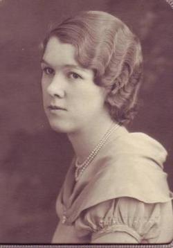


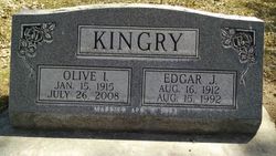
Olive Ione Williams Kingry
| Birth | : | 15 Jan 1915 Banner County, Nebraska, USA |
| Death | : | 26 Jul 2008 Alliance, Box Butte County, Nebraska, USA |
| Burial | : | Warwick General Cemetery, Warwick, Southern Downs Region, Australia |
| Coordinate | : | -28.2100890, 152.0044080 |
| Plot | : | Lot 13 Section 01 Block 11 |
| Description | : | Daughter of Glenn George Williams of Lushton, York County, Nebraska and Rhoda Berniece English of Mason City, Custer County, Nebraska. Wife of Edgar John Kingry of Ames, Dodge County, Nebraska; married on 07 April 1934 in Bridgeport, Morrill County, Nebraska. "Olive Ione Kingry, 93, died Saturday, July 26, 2008 at the Good Samaritan Health Care Center. Olive was born January 15, 1915 at Flowerfield, Nebraska to Glenn and Rhoda (English) Williams. She attended school at Harrisburg, Nebraska. She married Edgar J. Kingry on April 7, 1934 in Bridgeport, Nebraska. They had four children, Edward, Marvin, Gordon, and Lois. Olive taught school in rural Box Butte... Read More |
frequently asked questions (FAQ):
-
Where is Olive Ione Williams Kingry's memorial?
Olive Ione Williams Kingry's memorial is located at: Warwick General Cemetery, Warwick, Southern Downs Region, Australia.
-
When did Olive Ione Williams Kingry death?
Olive Ione Williams Kingry death on 26 Jul 2008 in Alliance, Box Butte County, Nebraska, USA
-
Where are the coordinates of the Olive Ione Williams Kingry's memorial?
Latitude: -28.2100890
Longitude: 152.0044080
Family Members:
Parent

Spouse
Siblings
Children
Flowers:


Nearby Cemetories:
1. Warwick General Lawn Cemetery
Warwick, Southern Downs Region, Australia
Coordinate: -28.2106310, 152.0039087
2. Warwick War Cemetery
Warwick, Southern Downs Region, Australia
Coordinate: -28.2089620, 152.0033530
3. Eden Gardens Memorial Park
Warwick, Southern Downs Region, Australia
Coordinate: -28.2229690, 152.0031130
4. St Marks Anglican Church Columbarium Wall
Warwick, Southern Downs Region, Australia
Coordinate: -28.2161000, 152.0347600
5. Lone Grave Warwick
Warwick, Southern Downs Region, Australia
Coordinate: -28.2316590, 151.9833180
6. Warwick-Conway Family Homestead Cemetery
Warwick, Southern Downs Region, Australia
Coordinate: -28.1258400, 152.0395700
7. Swan Creek Anglican Cemetery
Swan Creek, Southern Downs Region, Australia
Coordinate: -28.1974400, 152.1364830
8. Glengallan Station
Warwick, Southern Downs Region, Australia
Coordinate: -28.1027016, 152.0585067
9. Yangan Presbyterian Church Cemetery
Yangan, Southern Downs Region, Australia
Coordinate: -28.1972310, 152.2142130
10. Yangan General and Anglican Cemetery
Emu Vale, Southern Downs Region, Australia
Coordinate: -28.2059990, 152.2207110
11. Allora Cemetery
Allora, Southern Downs Region, Australia
Coordinate: -28.0199230, 151.9750720
12. Pratten Cemetery
Pratten, Southern Downs Region, Australia
Coordinate: -28.0858450, 151.7790540
13. Dalveen-Mitchell Family Homestead Cemetery
Dalveen, Southern Downs Region, Australia
Coordinate: -28.4423200, 151.9604000
14. Maryvale Homestead Cemetery
Warwick, Southern Downs Region, Australia
Coordinate: -28.0669430, 152.2405230
15. Maryvale Cemetery
Maryvale, Southern Downs Region, Australia
Coordinate: -28.0607800, 152.2474610
16. Killarney Lawn Cemetery
Killarney, Southern Downs Region, Australia
Coordinate: -28.3475760, 152.2742790
17. Strath Elbess Cemetery
Dalveen, Southern Downs Region, Australia
Coordinate: -28.4883070, 151.9692850
18. Clifton General Cemetery
Clifton, Toowoomba Region, Australia
Coordinate: -27.9389150, 151.9120790
19. Headington Hill Lutheran Cemetery
Allora, Southern Downs Region, Australia
Coordinate: -27.9037210, 152.0020290
20. Back Plains Cemetery
Back Plains, Toowoomba Region, Australia
Coordinate: -27.9121770, 151.7970240
21. Spicers Gap
Boonah, Scenic Rim Region, Australia
Coordinate: -28.0733318, 152.4255524
22. Nobby Cemetery
Nobby, Toowoomba Region, Australia
Coordinate: -27.8322200, 151.8662000
23. Leyburn Cemetery
Leyburn, Southern Downs Region, Australia
Coordinate: -28.0085654, 151.5913366
24. Lone Grave Leyburn
Leyburn, Southern Downs Region, Australia
Coordinate: -28.0189540, 151.5842910