
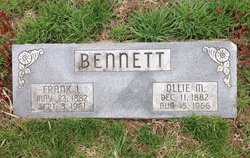
Olive May “Ollie” Barker Bennett
| Birth | : | 11 Dec 1882 Pawnee County, Nebraska, USA |
| Death | : | 15 Aug 1966 Tulsa, Tulsa County, Oklahoma, USA |
| Burial | : | Pawnee City Cemetery, Pawnee City, Pawnee County, USA |
| Coordinate | : | 40.1109009, -96.1608810 |
| Plot | : | W 227- 1 |
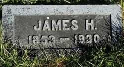
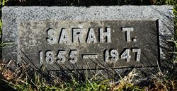
| Description | : | The second child of James H. and Sarah T. Barker. Married to Franklin LeRoy Bennett on June 1, 1904. They were the parents of five children: Franklin, Gerald, Donald, Doris and Marjorie. THE PAWNEE REPUBLICAN, Pawnee City, Nebraska,Thursday, August 25, 1966. Page 8. OBITUARIES- OLIVE MAY BENNETT Olive May Bennett, second child of James H. and Sarah T. Barker, was born December 11, 1882, and died August 15, 1966, aged 83 years, 8 months and 4 days. Mrs. Bennett was born in Pawnee County, Nebraska; and Nebraska was always her home until the last five years. On August 1st... Read More |
frequently asked questions (FAQ):
-
Where is Olive May “Ollie” Barker Bennett's memorial?
Olive May “Ollie” Barker Bennett's memorial is located at: Pawnee City Cemetery, Pawnee City, Pawnee County, USA.
-
When did Olive May “Ollie” Barker Bennett death?
Olive May “Ollie” Barker Bennett death on 15 Aug 1966 in Tulsa, Tulsa County, Oklahoma, USA
-
Where are the coordinates of the Olive May “Ollie” Barker Bennett's memorial?
Latitude: 40.1109009
Longitude: -96.1608810
Family Members:
Parent
Spouse

Siblings


Children
Flowers:


Nearby Cemetories:
1. Pawnee City Cemetery
Pawnee City, Pawnee County, USA
Coordinate: 40.1109009, -96.1608810
2. East Amish Cemetery
Table Rock, Pawnee County, USA
Coordinate: 40.1310000, -96.0854000
3. Evergreen Cemetery
Pawnee County, USA
Coordinate: 40.0485992, -96.1417007
4. Pleasant Valley Cemetery
Pawnee County, USA
Coordinate: 40.0299988, -96.1554794
5. Table Rock Cemetery
Table Rock, Pawnee County, USA
Coordinate: 40.1791400, -96.1037400
6. Prairie Star Pioneer Cemetery
Du Bois, Pawnee County, USA
Coordinate: 40.0293000, -96.1041000
7. Beranek Cemetery
Table Rock, Pawnee County, USA
Coordinate: 40.2042007, -96.1607971
8. Pleasant Ridge Cemetery
Du Bois, Pawnee County, USA
Coordinate: 40.0156000, -96.1494000
9. West Branch Cemetery
Pawnee County, USA
Coordinate: 40.0787940, -96.2797160
10. Saint Anthonys Cemetery
Steinauer, Pawnee County, USA
Coordinate: 40.2075005, -96.2189026
11. Johnson Creek Cemetery
Pawnee City, Pawnee County, USA
Coordinate: 40.0270000, -96.2465000
12. Clear Creek Cemetery
Table Rock, Pawnee County, USA
Coordinate: 40.2193985, -96.1391983
13. Bohemian Cemetery
Table Rock, Pawnee County, USA
Coordinate: 40.1786003, -96.0374985
14. Saint Peters Evangelican Cemetery
Du Bois, Pawnee County, USA
Coordinate: 40.0010000, -96.1095000
15. Dry Branch Pioneer Cemetery
Richardson County, USA
Coordinate: 40.1292000, -96.0100021
16. DuBois Cemetery
Du Bois, Pawnee County, USA
Coordinate: 40.0231018, -96.0488968
17. Bohemian Cemetery
Richardson County, USA
Coordinate: 40.1175003, -95.9955978
18. Saint Johns Cemetery
Table Rock, Pawnee County, USA
Coordinate: 40.2148000, -96.0657000
19. Salems Cemetery
Steinauer, Pawnee County, USA
Coordinate: 40.2166000, -96.2555000
20. McCaffrey Cemetery
Nemaha County, USA
Coordinate: 39.9827100, -96.1474500
21. Madden Cemetery
Axtell, Marshall County, USA
Coordinate: 39.9866800, -96.2490300
22. Friedens United Church of Christ Cemetery
Bern, Nemaha County, USA
Coordinate: 39.9929008, -96.0529480
23. Saint Peters Lutheran Church Cemetery
Steinauer, Pawnee County, USA
Coordinate: 40.2555000, -96.1801000
24. Cincinnati Cemetery
Du Bois, Pawnee County, USA
Coordinate: 40.0042000, -96.0274963