
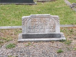
Ollie Mae Fuller Moore
| Birth | : | 16 Sep 1887 Winder, Barrow County, Georgia, USA |
| Death | : | 16 Mar 1948 Anderson, Anderson County, South Carolina, USA |
| Burial | : | Attwood Cemetery, Kidsgrove, Newcastle-Under-Lyme Borough, England |
| Coordinate | : | 53.0889200, -2.2350700 |
| Plot | : | South Side, Block W, Lot 81 |
| Description | : | "Ollie May Fuller Moore, "South Carolina, Deaths, 1944-1955" name: Ollie May Fuller Moore death date: 16 Mar 1948 death place: Anderson, Anderson, South Carolina gender: Female age at death: 62y estimated birth date: 1886 birth date: birthplace: marital status: Married spouse's name: William Clayton Moore father's name: Martin Fuller film number: 2396305 reference number: cn 04221 |
frequently asked questions (FAQ):
-
Where is Ollie Mae Fuller Moore's memorial?
Ollie Mae Fuller Moore's memorial is located at: Attwood Cemetery, Kidsgrove, Newcastle-Under-Lyme Borough, England.
-
When did Ollie Mae Fuller Moore death?
Ollie Mae Fuller Moore death on 16 Mar 1948 in Anderson, Anderson County, South Carolina, USA
-
Where are the coordinates of the Ollie Mae Fuller Moore's memorial?
Latitude: 53.0889200
Longitude: -2.2350700
Family Members:
Parent
Spouse
Siblings
Children
Flowers:

Left by Anonymous on 21 Oct 2010

Left by Anonymous on 04 Nov 2012

Left by Anonymous on 30 Nov 2012

Left by Anonymous on 13 Dec 2012

Left by Anonymous on 10 Apr 2013
Left by Anonymous on 21 Oct 2010
Left by Anonymous on 04 Nov 2012
Left by Anonymous on 30 Nov 2012
Left by Anonymous on 13 Dec 2012
Left by Anonymous on 10 Apr 2013


Nearby Cemetories:
1. St. James the Apostle Churchyard
Newchapel, Newcastle-Under-Lyme Borough, England
Coordinate: 53.0874630, -2.2069790
2. St. John the Evangelist Churchyard
Goldenhill, Stoke-on-Trent Unitary Authority, England
Coordinate: 53.0749010, -2.2189830
3. St Martin Churchyard
Talke, Newcastle-Under-Lyme Borough, England
Coordinate: 53.0755440, -2.2618170
4. All Saints Churchyard
Church Lawton, Cheshire East Unitary Authority, England
Coordinate: 53.0987050, -2.2679300
5. St Thomas Churchyard
Mow Cop, Newcastle-Under-Lyme Borough, England
Coordinate: 53.1127280, -2.2101350
6. Tunstall Cemetery
Tunstall, Stoke-on-Trent Unitary Authority, England
Coordinate: 53.0618690, -2.2180260
7. Christ Church Churchyard
Tunstall, Stoke-on-Trent Unitary Authority, England
Coordinate: 53.0625400, -2.2112840
8. All Saints Churchyard
Odd Rode, Cheshire East Unitary Authority, England
Coordinate: 53.1142100, -2.2644690
9. St Mary Magdalene Churchyard
Alsager, Cheshire East Unitary Authority, England
Coordinate: 53.0960640, -2.3071370
10. Audley Methodist Church Cemetery
Bignall End, Newcastle-Under-Lyme Borough, England
Coordinate: 53.0574320, -2.2944720
11. Holy Trinity Churchyard
Chesterton, Stratford-on-Avon District, England
Coordinate: 53.0418320, -2.2523770
12. Christ Church Churchyard
Alsager, Cheshire East Unitary Authority, England
Coordinate: 53.0977630, -2.3166660
13. St John the Baptist Churchyard
Burslem, Stoke-on-Trent Unitary Authority, England
Coordinate: 53.0425850, -2.1962510
14. St James the Great Churchyard
Audley, Newcastle-Under-Lyme Borough, England
Coordinate: 53.0548480, -2.3014800
15. Parish church of st saviour smallthorne
Smallthorne, Stoke-on-Trent Unitary Authority, England
Coordinate: 53.0497445, -2.1758707
16. St Bartholomew Churchyard
Norton in the Moors, Stoke-on-Trent Unitary Authority, England
Coordinate: 53.0604630, -2.1595270
17. Smallthorne Cemetery
Smallthorne, Stoke-on-Trent Unitary Authority, England
Coordinate: 53.0480310, -2.1765950
18. Chesterton Cemetery
Newcastle-under-Lyme, Newcastle-Under-Lyme Borough, England
Coordinate: 53.0352240, -2.2500500
19. St Anne Churchyard
Brown Edge, Staffordshire Moorlands District, England
Coordinate: 53.0832490, -2.1429880
20. Burslem Cemetery
Burslem, Stoke-on-Trent Unitary Authority, England
Coordinate: 53.0463020, -2.1747030
21. Audley Cemetery
Audley, Newcastle-Under-Lyme Borough, England
Coordinate: 53.0550140, -2.3103040
22. St. Lawrence Churchyard
Biddulph, Staffordshire Moorlands District, England
Coordinate: 53.1281320, -2.1659070
23. St John the Baptist Churchyard
Smallwood, Cheshire East Unitary Authority, England
Coordinate: 53.1381700, -2.2913100
24. St Margaret Churchyard
Wolstanton, Newcastle-Under-Lyme Borough, England
Coordinate: 53.0296810, -2.2154990