
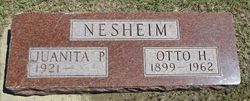
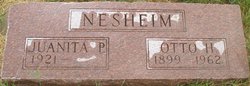
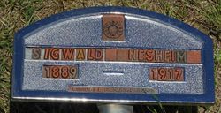
Otto Herman Nesheim
| Birth | : | 14 Aug 1899 Decorah, Winneshiek County, Iowa, USA |
| Death | : | 23 Dec 1962 Pierre, Hughes County, South Dakota, USA |
| Burial | : | Wyndham Cemetery, Wyndham, Southland District, New Zealand |
| Coordinate | : | -46.3147020, 168.8823690 |
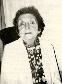
| Description | : | Otto Nesheim was born at Decorah, Iowa on August 14, 1899. He was baptised in the Big Springs Lutheran Church of Decorah. In 1908 he moved with his parents to the Moenville community where he grew to manhood and lived until six years ago when he and his family moved to Pierre. He was confirmed into the Deep Creek Lutheran Church. He was united in marriage September 11, 1942 to Juanita Hand. To this union two children, Irma 12 and Vernon 19, were born and with the wife survive him. He passed away December... Read More |
frequently asked questions (FAQ):
-
Where is Otto Herman Nesheim's memorial?
Otto Herman Nesheim's memorial is located at: Wyndham Cemetery, Wyndham, Southland District, New Zealand.
-
When did Otto Herman Nesheim death?
Otto Herman Nesheim death on 23 Dec 1962 in Pierre, Hughes County, South Dakota, USA
-
Where are the coordinates of the Otto Herman Nesheim's memorial?
Latitude: -46.3147020
Longitude: 168.8823690
Family Members:
Parent
Spouse
Siblings


Flowers:


Nearby Cemetories:
1. Wyndham Cemetery
Wyndham, Southland District, New Zealand
Coordinate: -46.3147020, 168.8823690
2. Edendale Cemetery
Edendale, Southland District, New Zealand
Coordinate: -46.3080400, 168.7327360
3. Mataura Cemetery
Mataura, Gore District, New Zealand
Coordinate: -46.2016960, 168.8808060
4. Mokoreta Cemetery
Southland District, New Zealand
Coordinate: -46.4332000, 169.0649650
5. Otaraia Cemetery
Gore District, New Zealand
Coordinate: -46.1978780, 169.0815990
6. Charlton Park Cemetery
Gore, Gore District, New Zealand
Coordinate: -46.1265490, 168.8992730
7. Gore Cemetery
Gore, Gore District, New Zealand
Coordinate: -46.0900000, 168.9360000
8. Woodlands Cemetery
Woodlands, Southland District, New Zealand
Coordinate: -46.3568800, 168.5463770
9. Quarry Hills Cemetery
Quarry Hills, Southland District, New Zealand
Coordinate: -46.5433100, 169.0398300
10. Fortrose Cemetery
Fortrose, Southland District, New Zealand
Coordinate: -46.5694400, 168.8088500
11. Pukerau Cemetery
Pukerau, Gore District, New Zealand
Coordinate: -46.0989170, 169.1057690
12. Waipahi Cemetery
Waipahi, Clutha District, New Zealand
Coordinate: -46.1019420, 169.2380910
13. Waikawa Cemetery
Waikawa, Southland District, New Zealand
Coordinate: -46.6093780, 169.1289750
14. Tararua Acre
Otara, Southland District, New Zealand
Coordinate: -46.6551940, 168.8762500
15. Te Hau Mutunga Urupā
Invercargill, Invercargill City, New Zealand
Coordinate: -46.4288704, 168.4148361
16. Waikoikoi Cemetery
Waikoikoi, Clutha District, New Zealand
Coordinate: -46.0257040, 169.1568238
17. Eastern Cemetery
Invercargill, Invercargill City, New Zealand
Coordinate: -46.4070770, 168.3961480
18. Southland Crematorium
Invercargill, Invercargill City, New Zealand
Coordinate: -46.4109100, 168.3961330
19. Clinton Cemetery
Clinton, Clutha District, New Zealand
Coordinate: -46.1971400, 169.3638100
20. Forest Hill Cemetery
Southland District, New Zealand
Coordinate: -46.2049720, 168.3969970
21. Holy Trinity Anglican Church
Invercargill, Invercargill City, New Zealand
Coordinate: -46.3984736, 168.3660057
22. All Saints Anglican Church
Invercargill, Invercargill City, New Zealand
Coordinate: -46.3906042, 168.3476728
23. Saint Johns Cemetery
Invercargill, Invercargill City, New Zealand
Coordinate: -46.3748600, 168.3431480
24. Ryal Bush
Ryal Bush, Southland District, New Zealand
Coordinate: -46.2836700, 168.3256000