| Birth | : | 2 Jun 1894 Colbert Township, Bryan County, Oklahoma, USA |
| Death | : | 10 Oct 1895 Colbert Township, Bryan County, Oklahoma, USA |
| Burial | : | Jaroso Cemetery, Costilla County, USA |
| Coordinate | : | 37.0179400, -105.6274800 |
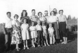
| Description | : | Baby Otto Kinder born in Colbert Township, Oklahoma June 2, 1894: Died 10/10/1895, Colbert Township, Oklahoma A Baby Picture before his death was taken about 1995 Spring Born to Charles Lee Kinder and Mamie Kinder in Colbert, Oklahoma, Picture of Parents shown on this Memorial Page He had 9 Brothers and Sisters Pictures of his family at the turn of the Century is included as is a picture of his parents Charlie and Mammie Kinder |
frequently asked questions (FAQ):
-
Where is Otto Kinder's memorial?
Otto Kinder's memorial is located at: Jaroso Cemetery, Costilla County, USA.
-
When did Otto Kinder death?
Otto Kinder death on 10 Oct 1895 in Colbert Township, Bryan County, Oklahoma, USA
-
Where are the coordinates of the Otto Kinder's memorial?
Latitude: 37.0179400
Longitude: -105.6274800
Family Members:
Parent
Siblings
Flowers:
Nearby Cemetories:
1. Jaroso Cemetery
Costilla County, USA
Coordinate: 37.0179400, -105.6274800
2. Eastdale Cemetery
Eastdale, Costilla County, USA
Coordinate: 37.0293420, -105.6512270
3. Garcia Cemetery
Costilla County, USA
Coordinate: 37.0101360, -105.5439600
4. Garcia Pentecostal Cemetery
Garcia, Costilla County, USA
Coordinate: 37.0099470, -105.5430150
5. Garcia Presbyterian Cemetery
Garcia, Costilla County, USA
Coordinate: 37.0042000, -105.5437000
6. Sacred Heart Catholic Cemetery
Costilla, Taos County, USA
Coordinate: 36.9882000, -105.5402000
7. Mesita Cemetery
Mesita, Costilla County, USA
Coordinate: 37.1038000, -105.6029000
8. Sunshine Valley Cemetery
Taos County, USA
Coordinate: 36.8650017, -105.6402969
9. Amalia Cemetery
Amalia, Taos County, USA
Coordinate: 36.9452000, -105.4571000
10. San Acacio New Cemetery
San Acacio, Costilla County, USA
Coordinate: 37.1930000, -105.5097000
11. San Acacio Old Cemetery
San Acacio, Costilla County, USA
Coordinate: 37.2018000, -105.5079000
12. Latir Cemetery
Taos County, USA
Coordinate: 36.8083000, -105.5742035
13. Lobatos Cemetery
Conejos County, USA
Coordinate: 37.0630989, -105.9116974
14. Los Fuertes Cemetery
San Pablo, Costilla County, USA
Coordinate: 37.1342000, -105.3686000
15. San Francisco Cemetery
Costilla County, USA
Coordinate: 37.1062000, -105.3510000
16. Los Lasauses Pentecostal Cemetery
Los Sauces, Conejos County, USA
Coordinate: 37.2362520, -105.7557920
17. Gate to Heaven Cemetery
Los Sauces, Conejos County, USA
Coordinate: 37.2375000, -105.7560000
18. Chama Assemblies of God Cemetery
Chama, Costilla County, USA
Coordinate: 37.1545460, -105.3730070
19. Chama Cemetery
Chama, Costilla County, USA
Coordinate: 37.1561012, -105.3719025
20. Flower Family Graves
Manassa, Conejos County, USA
Coordinate: 37.1519000, -105.8915000
21. Old Chama Catholic Cemetery
Chama, Costilla County, USA
Coordinate: 37.1620400, -105.3689300
22. San Luis Cemetery
San Luis, Costilla County, USA
Coordinate: 37.2013000, -105.4095000
23. San Luis Old Catholic Cemetery
San Luis, Costilla County, USA
Coordinate: 37.2014800, -105.4073200
24. Apostolic Church Cemetery
San Luis, Costilla County, USA
Coordinate: 37.2015320, -105.4058660


