
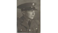
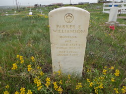
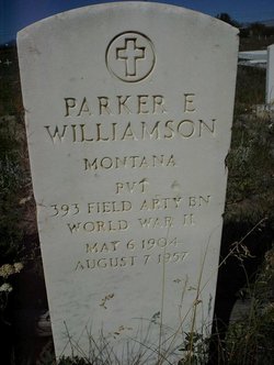

Parker Edward “Bud” Williamson
| Birth | : | 6 May 1904 Browning, Glacier County, Montana, USA |
| Death | : | 7 Aug 1957 Browning, Glacier County, Montana, USA |
| Burial | : | Saint Mary's Churchyard, Belford, Northumberland Unitary Authority, England |
| Coordinate | : | 55.5992600, -1.8292900 |
| Description | : | Not a lot is known about old Bud Williamson. He was the second oldest of eleven children of Jake A. Williamson and Margaret "Maggie" Allison-Williamson. He grew up on Flat Coulee on the Blackfeet Indian Reservation. In 1910, Parker attended school in Cut Bank, Glacier County (at that time the county was called Teton County). He enlisted in the U.S. Army 24 Apr 1941. His Military Occupation was Monotype Operator. He was 5' 5" tall and weighed 134 pounds at age 37. Later in life, oil was found on his land and he had a ranch and... Read More |
frequently asked questions (FAQ):
-
Where is Parker Edward “Bud” Williamson's memorial?
Parker Edward “Bud” Williamson's memorial is located at: Saint Mary's Churchyard, Belford, Northumberland Unitary Authority, England.
-
When did Parker Edward “Bud” Williamson death?
Parker Edward “Bud” Williamson death on 7 Aug 1957 in Browning, Glacier County, Montana, USA
-
Where are the coordinates of the Parker Edward “Bud” Williamson's memorial?
Latitude: 55.5992600
Longitude: -1.8292900
Family Members:
Parent
Spouse

Siblings

Children


Flowers:


Nearby Cemetories:
1. Saint Mary's Churchyard
Belford, Northumberland Unitary Authority, England
Coordinate: 55.5992600, -1.8292900
2. Saint Hilda’s Churchyard
Lucker, Northumberland Unitary Authority, England
Coordinate: 55.5660400, -1.7597400
3. St. Aidan Churchyard
Bamburgh, Northumberland Unitary Authority, England
Coordinate: 55.6079810, -1.7183070
4. Holy Cross Churchyard
Chatton, Northumberland Unitary Authority, England
Coordinate: 55.5474907, -1.9105738
5. St. Mary the Virgin Parish Churchyard
Holy Island, Northumberland Unitary Authority, England
Coordinate: 55.6694200, -1.8016450
6. Saint Nicholas Churchyard
Kyloe, Northumberland Unitary Authority, England
Coordinate: 55.6569000, -1.9188300
7. Kyloe Cemetery
Kyloe, Northumberland Unitary Authority, England
Coordinate: 55.6570310, -1.9191950
8. St. Peter's Parish Church
Chillingham, Northumberland Unitary Authority, England
Coordinate: 55.5273100, -1.9030830
9. St Maurice's Churchyard
Ellingham, Northumberland Unitary Authority, England
Coordinate: 55.5245000, -1.7245300
10. St John the Baptist Churchyard
Lowick, Northumberland Unitary Authority, England
Coordinate: 55.6501470, -1.9826250
11. St Mary & St Michael Churchyard
Doddington, Northumberland Unitary Authority, England
Coordinate: 55.5837211, -2.0083409
12. Beadnell cemetery
Beadnell, Northumberland Unitary Authority, England
Coordinate: 55.5572940, -1.6398270
13. Saint Ebba Churchyard
Beadnell, Northumberland Unitary Authority, England
Coordinate: 55.5566380, -1.6375270
14. Grey Family Cemetery
Fallodon, Northumberland Unitary Authority, England
Coordinate: 55.5058580, -1.6760530
15. St Maurice Churchyard
Eglingham, Northumberland Unitary Authority, England
Coordinate: 55.4689000, -1.8336000
16. St. Michael Churchyard
Ilderton, Northumberland Unitary Authority, England
Coordinate: 55.4904200, -1.9743800
17. St. Anne's Churchyard
Ancroft, Northumberland Unitary Authority, England
Coordinate: 55.7000400, -1.9981800
18. Rock Church of St. Philip and St. James
Alnwick, Northumberland Unitary Authority, England
Coordinate: 55.4755200, -1.6817200
19. St Michael and All Angels Churchyard
Ford, Northumberland Unitary Authority, England
Coordinate: 55.6301700, -2.0895430
20. Holy Trinity Churchyard
Embleton, Northumberland Unitary Authority, England
Coordinate: 55.4955790, -1.6360190
21. Embleton Churchyard
Embleton, Northumberland Unitary Authority, England
Coordinate: 55.4884280, -1.6333460
22. St. Mary the Virgin Chapelyard
Etal, Northumberland Unitary Authority, England
Coordinate: 55.6481100, -2.1150200
23. All Saints Churchyard
Duddo, Northumberland Unitary Authority, England
Coordinate: 55.6859800, -2.0862900
24. Hulne Priory
Alnwick, Northumberland Unitary Authority, England
Coordinate: 55.4350530, -1.7430160