
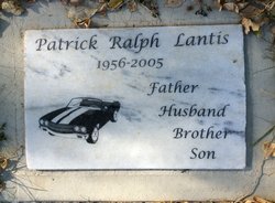
Patrick Ralph Lantis
| Birth | : | 14 Feb 1956 Coeur d'Alene, Kootenai County, Idaho, USA |
| Death | : | 24 Mar 2005 Miles City, Custer County, Montana, USA |
| Burial | : | Elmswell Cemetery, Elmswell, Mid Suffolk District, England |
| Coordinate | : | 52.2328720, 0.8992110 |
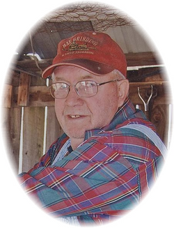
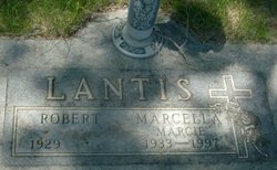
| Description | : | Patrick Ralph was born on Tuesday February 14, 1956 to Robert and Marcie Rogge Lantis in CouerD' Alene, Idaho. Patrick graduated from Terry Public School. After graduation he married Roxann Joy Stroh on Sunday June 01, 1975. They moved to Fallon, Montana. Later moving to Casper, Wyoming then moving to Miles City, where he worked for Trinity Rail Car Services. Pat enjoyed fishing, camping, hunting, Demolition Derbies, racing drag strip cars, working on vechicles and planting his garden. Pat enjoyed spending time with his family and friends. Patrick passed away on Saturday March 24,... Read More |
frequently asked questions (FAQ):
-
Where is Patrick Ralph Lantis's memorial?
Patrick Ralph Lantis's memorial is located at: Elmswell Cemetery, Elmswell, Mid Suffolk District, England.
-
When did Patrick Ralph Lantis death?
Patrick Ralph Lantis death on 24 Mar 2005 in Miles City, Custer County, Montana, USA
-
Where are the coordinates of the Patrick Ralph Lantis's memorial?
Latitude: 52.2328720
Longitude: 0.8992110
Family Members:
Parent
Siblings
Flowers:


Nearby Cemetories:
1. Elmswell Cemetery
Elmswell, Mid Suffolk District, England
Coordinate: 52.2328720, 0.8992110
2. St John the Divine Churchyard
Elmswell, Mid Suffolk District, England
Coordinate: 52.2350000, 0.9014815
3. Methodist Church Burial Ground
Elmswell, Mid Suffolk District, England
Coordinate: 52.2371320, 0.9097780
4. All Saints Churchyard
Drinkstone, Mid Suffolk District, England
Coordinate: 52.2178910, 0.8674070
5. Norton Baptist Church
Norton, Mid Suffolk District, England
Coordinate: 52.2541360, 0.8657970
6. St. Andrew's Churchyard
Norton, Mid Suffolk District, England
Coordinate: 52.2600350, 0.8737990
7. King Charles the Martyr Churchyard
Shelland, Mid Suffolk District, England
Coordinate: 52.2039070, 0.9307170
8. Rattlesden Cemetery
Rattlesden, Mid Suffolk District, England
Coordinate: 52.1961530, 0.8947200
9. St Nicholas Churchyard
Rattlesden, Mid Suffolk District, England
Coordinate: 52.1941810, 0.8926210
10. Rattlesden Baptist Church
Rattlesden, Mid Suffolk District, England
Coordinate: 52.1924020, 0.8885300
11. St. Mary the Virgin's Church
Haughley, Mid Suffolk District, England
Coordinate: 52.2215800, 0.9647260
12. St Ethelbert Churchyard
Hessett, Mid Suffolk District, England
Coordinate: 52.2206810, 0.8341060
13. All Saints Churchyard
Great Ashfield, Mid Suffolk District, England
Coordinate: 52.2719990, 0.9234480
14. St Michael Churchyard
Hunston, Mid Suffolk District, England
Coordinate: 52.2750420, 0.8947420
15. All Saints Churchyard
Beyton, Mid Suffolk District, England
Coordinate: 52.2290300, 0.8301100
16. St. Augustine's Church Burial Ground
Harleston, Mid Suffolk District, England
Coordinate: 52.2045920, 0.9526440
17. St George Churchyard
Stowlangtoft, Mid Suffolk District, England
Coordinate: 52.2771010, 0.8683970
18. St John the Baptist Churchyard
Onehouse, Mid Suffolk District, England
Coordinate: 52.1956290, 0.9495420
19. Badwell Ash Cemetery
Badwell Ash, Mid Suffolk District, England
Coordinate: 52.2822470, 0.9168550
20. St. Mary's in the Field
Langham, Mid Suffolk District, England
Coordinate: 52.2837690, 0.9022270
21. Saint Mary Churchyard
Badwell Ash, Mid Suffolk District, England
Coordinate: 52.2829360, 0.9152840
22. St. Mary's Churchyard
Gedding, Mid Suffolk District, England
Coordinate: 52.1865920, 0.8540510
23. Saint Mary's Churchyard
Buxhall, Mid Suffolk District, England
Coordinate: 52.1803740, 0.9283610
24. St Mary Parish Churchyard
Pakenham, St Edmundsbury Borough, England
Coordinate: 52.2678260, 0.8268340