

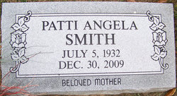
Patti Angela Shroyer Smith
| Birth | : | 5 Jul 1932 Eldon, Miller County, Missouri, USA |
| Death | : | 30 Dec 2009 Jefferson City, Cole County, Missouri, USA |
| Burial | : | Olean Cemetery, Olean, Miller County, USA |
| Coordinate | : | 38.4131012, -92.5413971 |
| Description | : | Phillips Funeral Home Web Site, December 2009 Patti Angela (Shroyer) Smith, 77, passed away Wednesday evening December 30, 2009 at the Golden Living Center in Jefferson City, Missouri. On July 5, 1932 she was born in Eldon, Missouri to the late William Oscar "Jack" and Estelle Mae (McClain) Shroyer. Her husband, Fred Lee Smith, Jr., preceded her on July 27, 1987. Survivors include: five children, Angela Smith of St. Louis, Missouri, William "Jeff" Smith of Harrisburg, PA, Dorothy Tunseth of Mesa, Arizona, Phillip Bustamante of Eldon, Missouri, Gina Bustamante of Brazito, Missouri; ten grandchildren, Sean Smith, Danyelle Benza, Dustin... Read More |
frequently asked questions (FAQ):
-
Where is Patti Angela Shroyer Smith's memorial?
Patti Angela Shroyer Smith's memorial is located at: Olean Cemetery, Olean, Miller County, USA.
-
When did Patti Angela Shroyer Smith death?
Patti Angela Shroyer Smith death on 30 Dec 2009 in Jefferson City, Cole County, Missouri, USA
-
Where are the coordinates of the Patti Angela Shroyer Smith's memorial?
Latitude: 38.4131012
Longitude: -92.5413971
Family Members:
Parent
Siblings
Flowers:


Nearby Cemetories:
1. Olean Cemetery
Olean, Miller County, USA
Coordinate: 38.4131012, -92.5413971
2. Green Ridge Baptist Church Cemetery
Eldon, Miller County, USA
Coordinate: 38.4116200, -92.5645700
3. Etter-Walker Cemetery
Burris Fork, Moniteau County, USA
Coordinate: 38.4333700, -92.5525400
4. Walker Cemetery
Moniteau County, USA
Coordinate: 38.4338989, -92.5522003
5. Farris Cemetery
Moniteau County, USA
Coordinate: 38.4369900, -92.5380000
6. Allen Cemetery
Olean, Miller County, USA
Coordinate: 38.4150009, -92.5008011
7. Jackson Chapel Methodist Church Cemetery
California, Moniteau County, USA
Coordinate: 38.4447900, -92.5286500
8. Gray Cemetery
Moniteau County, USA
Coordinate: 38.4536018, -92.5456009
9. Hite Cemetery
Miller County, USA
Coordinate: 38.4039001, -92.5935974
10. Mount Pleasant Cemetery
Eldon, Miller County, USA
Coordinate: 38.3667700, -92.5300800
11. Salem Cemetery
Saline Township, Miller County, USA
Coordinate: 38.3691232, -92.5697260
12. Salem Cemetery
Eldon, Miller County, USA
Coordinate: 38.3697014, -92.5714035
13. Mount Vernon Cemetery
Eldon, Miller County, USA
Coordinate: 38.3624992, -92.5606003
14. Bruce-Lewis-McGahan Cemetery
Enon, Moniteau County, USA
Coordinate: 38.4667500, -92.5172100
15. Rock Enon Cemetery
Miller County, USA
Coordinate: 38.4668400, -92.5170700
16. Eldon Cemetery
Eldon, Miller County, USA
Coordinate: 38.3642006, -92.5868988
17. Phillips Cemetery
High Point, Moniteau County, USA
Coordinate: 38.4430300, -92.6125300
18. Colburn Cemetery
Eldon, Miller County, USA
Coordinate: 38.4246300, -92.6275500
19. Depp Cemetery
High Point, Moniteau County, USA
Coordinate: 38.4776400, -92.5818500
20. High Point Cemetery
High Point, Moniteau County, USA
Coordinate: 38.4817009, -92.5757980
21. Phillips Cemetery
Barnett, Morgan County, USA
Coordinate: 38.4227982, -92.6367035
22. Matheis Cemetery
Russellville, Cole County, USA
Coordinate: 38.4571800, -92.4491600
23. United Baptist Church Cemetery
High Point, Moniteau County, USA
Coordinate: 38.4962200, -92.5856800
24. Karnes-Carney-Henderson Cemetery
Burris Fork, Moniteau County, USA
Coordinate: 38.4992100, -92.5007510