
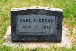
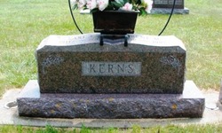
Paul S. Kerns
| Birth | : | 2 May 1899 Northup, Gallia County, Ohio, USA |
| Death | : | 4 May 1971 Britt, Hancock County, Iowa, USA |
| Burial | : | Gonic Village Cemetery, Gonic, Strafford County, USA |
| Coordinate | : | 43.2780420, -70.9797880 |
| Plot | : | 4-91-2 |
| Description | : | Obituary supplied by Chris Simonson on 16 May 2016: "Paul S. Kerns Rites Held At Plover Paul S. Kerns, 72, a former resident of the Rolfe and Plover areas, died at his home in Britt on Tuesday evening, May 4, after a long illness. Funeral services were held Friday afternoon at the United Methodist Church in Plover. The Rev. Howard J. Eldrenkamp of Britt and the Rev. Maurice Frevert of Plover were the officiants. Mrs. John Pollock, was the organist, and a men’s quartet, Curtis Kerns, Garland Westerman, John W. Nielsen and Perry Johnson sang “Abide With Me” and “Our Father Has Light In... Read More |
frequently asked questions (FAQ):
-
Where is Paul S. Kerns's memorial?
Paul S. Kerns's memorial is located at: Gonic Village Cemetery, Gonic, Strafford County, USA.
-
When did Paul S. Kerns death?
Paul S. Kerns death on 4 May 1971 in Britt, Hancock County, Iowa, USA
-
Where are the coordinates of the Paul S. Kerns's memorial?
Latitude: 43.2780420
Longitude: -70.9797880
Family Members:
Parent

Spouse
Siblings
Children

Flowers:


Nearby Cemetories:
1. Gonic Village Cemetery
Gonic, Strafford County, USA
Coordinate: 43.2780420, -70.9797880
2. Otis Family Cemetery
Gonic, Strafford County, USA
Coordinate: 43.2692012, -70.9901888
3. Ham-Clark Cemetery
Gonic, Strafford County, USA
Coordinate: 43.2721260, -70.9952230
4. Hurd Cemetery
Gonic, Strafford County, USA
Coordinate: 43.2698590, -70.9938210
5. Saint Marys Cemetery
Rochester, Strafford County, USA
Coordinate: 43.2885160, -70.9666660
6. Holy Rosary Cemetery
Rochester, Strafford County, USA
Coordinate: 43.2933250, -70.9856770
7. Garland Cemetery
Gonic, Strafford County, USA
Coordinate: 43.2599400, -70.9801000
8. Brewster Farm Cemetery
Rochester, Strafford County, USA
Coordinate: 43.2958330, -70.9908330
9. Mont Calvaire Cemetery
Gonic, Strafford County, USA
Coordinate: 43.2568460, -70.9829700
10. French-Hussey Family Burial Ground
Rochester, Strafford County, USA
Coordinate: 43.2979400, -70.9918980
11. Old Cemetery
Rochester, Strafford County, USA
Coordinate: 43.2997210, -70.9683750
12. Foss Cemetery
Rochester, Strafford County, USA
Coordinate: 43.2844800, -71.0113800
13. Foss Family Cemetery
Rochester, Strafford County, USA
Coordinate: 43.2760360, -71.0156300
14. Rochester Cemetery
Rochester, Strafford County, USA
Coordinate: 43.3022003, -70.9630966
15. Jenness cemetery
Rochester, Strafford County, USA
Coordinate: 43.2889088, -70.9450590
16. Daggett Cemetery
Rochester, Strafford County, USA
Coordinate: 43.2499060, -70.9774740
17. Ramsbottom Family Cemetery
Rochester, Strafford County, USA
Coordinate: 43.2669440, -70.9411110
18. Clark Cemetery
Rochester, Strafford County, USA
Coordinate: 43.3009850, -71.0074390
19. Haven Hill Cemetery
Rochester, Strafford County, USA
Coordinate: 43.2841988, -70.9385986
20. Furber Cemetery
Rochester, Strafford County, USA
Coordinate: 43.3026000, -71.0077000
21. Old Town Cemetery
Rochester, Strafford County, USA
Coordinate: 43.3095200, -70.9913500
22. McDuffee Cemetery
Rochester, Strafford County, USA
Coordinate: 43.2452450, -70.9699030
23. Cater Family Lot
Barrington, Strafford County, USA
Coordinate: 43.2577300, -71.0182300
24. Darius Winkley Cemetery
Barrington, Strafford County, USA
Coordinate: 43.2497220, -71.0086110