
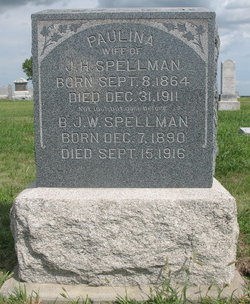

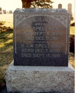
Pauline Beinhardt Spellman
| Birth | : | 8 Sep 1864 Harper, Keokuk County, Iowa, USA |
| Death | : | 31 Dec 1911 Clay County, Kansas, USA |
| Burial | : | Ebenezer Cemetery, Green, Clay County, USA |
| Coordinate | : | 39.3866997, -96.9974976 |
| Description | : | Obit – Paulina (Beinhart) Spellman Mrs. Pauline Spellman, nee Beinhart, was born September 8, 1864 at harper, Keokuck County, Iowa, and died Sunday, December 31, at 2:45 o'clock in the morning at her home five and one-half miles east of Clay Center. Consumption was the cause of her death. The deceased became the wife of John H. Spellman August 11, 1885, and went at once to Kramer, Nebr., to live, residing there until 1903 when they came to Clay County, buying the farm east of Clay Center. They lived there ever after. The husband and their three sons, David, Benjamin and... Read More |
frequently asked questions (FAQ):
-
Where is Pauline Beinhardt Spellman's memorial?
Pauline Beinhardt Spellman's memorial is located at: Ebenezer Cemetery, Green, Clay County, USA.
-
When did Pauline Beinhardt Spellman death?
Pauline Beinhardt Spellman death on 31 Dec 1911 in Clay County, Kansas, USA
-
Where are the coordinates of the Pauline Beinhardt Spellman's memorial?
Latitude: 39.3866997
Longitude: -96.9974976
Family Members:
Parent

Spouse
Siblings
Children
Flowers:


Nearby Cemetories:
1. Ebenezer Cemetery
Green, Clay County, USA
Coordinate: 39.3866997, -96.9974976
2. Green Cemetery
Green, Clay County, USA
Coordinate: 39.4235992, -96.9882965
3. Lasita Cemetery
Leonardville, Riley County, USA
Coordinate: 39.4092900, -96.9422900
4. Clay County Poor Farm Cemetery
Clay Center, Clay County, USA
Coordinate: 39.3772700, -97.0727000
5. Pleasant Hill Cemetery
Leonardville, Riley County, USA
Coordinate: 39.4371210, -96.9426730
6. Broughton Cemetery
Clay Center, Clay County, USA
Coordinate: 39.3306007, -97.0535965
7. Fancy Creek Cemetery
Green, Clay County, USA
Coordinate: 39.4668999, -96.9969025
8. Hayes Cemetery
Clay County, USA
Coordinate: 39.4516983, -97.0811005
9. Bala Cemetery
Bala, Riley County, USA
Coordinate: 39.3053017, -96.9341965
10. Saint Peter and Saint Pauls Catholic Cemetery
Clay Center, Clay County, USA
Coordinate: 39.4005450, -97.1236680
11. Brethren in Christ Cemetery
Clay County, USA
Coordinate: 39.4810982, -97.0344009
12. Greenwood Cemetery
Clay Center, Clay County, USA
Coordinate: 39.4011002, -97.1275024
13. Leonardville Cemetery
Leonardville, Riley County, USA
Coordinate: 39.3792000, -96.8589020
14. Gilbert Cemetery
Clay County, USA
Coordinate: 39.2853012, -97.0625000
15. Milo Chapman Gravesite
Broughton, Clay County, USA
Coordinate: 39.2888500, -97.0724400
16. Gatesville Cemetery
Wakefield, Clay County, USA
Coordinate: 39.2721460, -97.0041380
17. Leonardville United Methodist Cemetery
Leonardville, Riley County, USA
Coordinate: 39.3568700, -96.8493600
18. May Day Cemetery
Center Township, Riley County, USA
Coordinate: 39.4958000, -96.9302979
19. Goshen Central Cemetery
Clay Center, Clay County, USA
Coordinate: 39.5099983, -97.0160980
20. Joseph Sender Family Cemetery
Clay County, USA
Coordinate: 39.5090600, -97.0348800
21. Crooked Creek Cemetery
Randolph, Riley County, USA
Coordinate: 39.4369011, -96.8480988
22. Swedish Pleasant Hill Cemetery
Clay Center, Clay County, USA
Coordinate: 39.4735985, -97.1268997
23. Republican City Cemetery
Clay Center, Clay County, USA
Coordinate: 39.3431015, -97.1628036
24. Idylwilde Cemetery
Clay Center, Clay County, USA
Coordinate: 39.5097900, -97.0713000