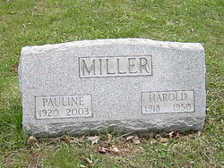
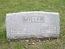
Pauline Mae Burt Miller
| Birth | : | 5 Jul 1920 Linesville, Crawford County, Pennsylvania, USA |
| Death | : | 6 Mar 2003 Ashtabula, Ashtabula County, Ohio, USA |
| Burial | : | Romford Cemetery, Romford, London Borough of Havering, England |
| Coordinate | : | 51.5693810, 0.1746850 |
| Description | : | Pauline Mae Reynolds ASHTABULA – Pauline Mae Reynolds, 82, of West 48th Street, died Thursday, March 6, 2003 at Ashtabula County Medical Center. She was born on July 5, 1920 in Linesville, Pennsylvania the daughter of Hazen and Maye E. (Peck) Burt and had been an area resident for most of her life. She enjoyed sewing, crocheting, and cooking for her family. Survivors include two sons, Harold A. and Jack B. Miller both of Ashtabula; a daughter, Paulette J. Wertz of St. George, Utah; 13 grandchildren; 27 great grandchildren; 3 great-great grandchildren; and a sister, Laura Good of Ashtabula. She was preceded in death by... Read More |
frequently asked questions (FAQ):
-
Where is Pauline Mae Burt Miller's memorial?
Pauline Mae Burt Miller's memorial is located at: Romford Cemetery, Romford, London Borough of Havering, England.
-
When did Pauline Mae Burt Miller death?
Pauline Mae Burt Miller death on 6 Mar 2003 in Ashtabula, Ashtabula County, Ohio, USA
-
Where are the coordinates of the Pauline Mae Burt Miller's memorial?
Latitude: 51.5693810
Longitude: 0.1746850
Family Members:
Spouse
Flowers:
Nearby Cemetories:
1. Romford Cemetery
Romford, London Borough of Havering, England
Coordinate: 51.5693810, 0.1746850
2. St. Andrew's Churchyard
Romford, London Borough of Havering, England
Coordinate: 51.5714570, 0.1837630
3. St Andrew's Church
Romford, London Borough of Havering, England
Coordinate: 51.5757696, 0.1728658
4. Eastbrookend Cemetery
Dagenham, London Borough of Barking and Dagenham, England
Coordinate: 51.5553150, 0.1820900
5. Chadwell Heath Cemetery
London Borough of Barking and Dagenham, England
Coordinate: 51.5861092, 0.1414030
6. St. Peter and St. Paul Churchyard
Dagenham, London Borough of Barking and Dagenham, England
Coordinate: 51.5397240, 0.1620340
7. St. Andrew's Churchyard
Hornchurch, London Borough of Havering, England
Coordinate: 51.5604880, 0.2260780
8. Hornchurch Cemetery
Hornchurch, London Borough of Havering, England
Coordinate: 51.5590370, 0.2264210
9. St. John the Evangelist Churchyard
Havering-atte-Bower, London Borough of Havering, England
Coordinate: 51.6161750, 0.1823690
10. St Laurence Churchyard
Upminster, London Borough of Havering, England
Coordinate: 51.5557430, 0.2478680
11. St Peter Churchyard
Aldborough Hatch, London Borough of Redbridge, England
Coordinate: 51.5835770, 0.1011510
12. Forest Park Cemetery & Crematorium
Hainault, London Borough of Redbridge, England
Coordinate: 51.6063370, 0.1239520
13. St Helen and St Giles Churchyard
Rainham, London Borough of Havering, England
Coordinate: 51.5183040, 0.1905660
14. Rainham Cemetery
Rainham, London Borough of Havering, England
Coordinate: 51.5221490, 0.2099420
15. St. Mary the Virgin Churchyard
Ilford, London Borough of Redbridge, England
Coordinate: 51.5615180, 0.0883200
16. Ilford Cemetery
Ilford, London Borough of Redbridge, England
Coordinate: 51.5607710, 0.0884910
17. Rainham Jewish Cemetery
Rainham, London Borough of Havering, England
Coordinate: 51.5226300, 0.2216150
18. Rippleside Cemetery
Barking, London Borough of Barking and Dagenham, England
Coordinate: 51.5351980, 0.1039920
19. South Essex Crematorium
Upminster, London Borough of Havering, England
Coordinate: 51.5433380, 0.2583840
20. Upminster Cemetery
Corbets Tey, London Borough of Havering, England
Coordinate: 51.5433330, 0.2592730
21. All Saints Churchyard
Cranham, London Borough of Havering, England
Coordinate: 51.5522750, 0.2660270
22. Tanners Lane
Barkingside, London Borough of Redbridge, England
Coordinate: 51.5876300, 0.0836420
23. All Saints Churchyard
Chigwell Row, Epping Forest District, England
Coordinate: 51.6189890, 0.1148840
24. St Thomas Churchyard
Noak Hill, London Borough of Havering, England
Coordinate: 51.6236572, 0.2246620


