
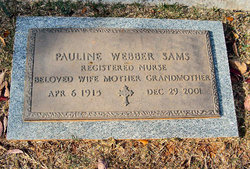
Pauline Webber Sams
| Birth | : | 6 Apr 1915 Cherokee County, South Carolina, USA |
| Death | : | 29 Dec 2001 Gaffney, Cherokee County, South Carolina, USA |
| Burial | : | Woodville Cemetery, Woodville, Newaygo County, USA |
| Coordinate | : | 43.6677780, -85.6808330 |
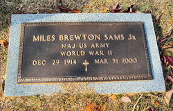
| Description | : | The Greenville News, Greenville, South Carolina, December 30, 2001. Pauline Webber Sams, 86, 223 Tiffany Park., died Dec. 29, 2001. She was a daughter of the late John Joseph and Minnie Ellis Webber and widow of Miles Brewton Sams, Jr. She was s registered nurse for Dr. Preston Edwards and member of Limestone Presbyterian Church. Surviving are a son, Miles Brewton Sams III of Gaffney, a daughter, Janie Sams Hayes of Kernersville, N.C. and six grandchildren. Visitation: 6 to 8 p.m. today at Shuford-Hatcher Funeral Home. Graveside services: 2 p.m. Monday at Oakland Cemetery. Memorial service: 3 p.m. Monday at Limestone... Read More |
frequently asked questions (FAQ):
-
Where is Pauline Webber Sams's memorial?
Pauline Webber Sams's memorial is located at: Woodville Cemetery, Woodville, Newaygo County, USA.
-
When did Pauline Webber Sams death?
Pauline Webber Sams death on 29 Dec 2001 in Gaffney, Cherokee County, South Carolina, USA
-
Where are the coordinates of the Pauline Webber Sams's memorial?
Latitude: 43.6677780
Longitude: -85.6808330
Family Members:
Parent
Spouse
Siblings
Flowers:


Nearby Cemetories:
1. Woodville Cemetery
Woodville, Newaygo County, USA
Coordinate: 43.6677780, -85.6808330
2. Merrill Township Cemetery
Brohman, Newaygo County, USA
Coordinate: 43.6650000, -85.6770000
3. Hungerford Cemetery
Norwich Township, Newaygo County, USA
Coordinate: 43.6935997, -85.6231003
4. Goodwell Cemetery
Goodwell Township, Newaygo County, USA
Coordinate: 43.5992012, -85.6235962
5. Paulsen Family Cemetery
White Cloud, Newaygo County, USA
Coordinate: 43.5767059, -85.7205392
6. Whipple Cemetery
Home Township, Newaygo County, USA
Coordinate: 43.7639008, -85.6828003
7. Hillers Cemetery
Merrill Township, Newaygo County, USA
Coordinate: 43.6789017, -85.8161011
8. Amish Cemetery
White Cloud, Newaygo County, USA
Coordinate: 43.5731010, -85.7217026
9. VanGilder Cemetery
Big Rapids Township, Mecosta County, USA
Coordinate: 43.7144508, -85.5587769
10. Davenport Cemetery
Barton Township, Newaygo County, USA
Coordinate: 43.7733330, -85.5819440
11. Mount Carmel Cemetery
Big Rapids, Mecosta County, USA
Coordinate: 43.7146187, -85.5154572
12. Fairview Cemetery
Mecosta Township, Mecosta County, USA
Coordinate: 43.5891991, -85.5335999
13. White Cloud Cemetery
White Cloud, Newaygo County, USA
Coordinate: 43.5527992, -85.7917023
14. Saint Joseph Cemetery
White Cloud, Newaygo County, USA
Coordinate: 43.5501671, -85.7900925
15. Highland View Cemetery
Big Rapids, Mecosta County, USA
Coordinate: 43.7032318, -85.4905319
16. Curtice Cemetery
Home Township, Newaygo County, USA
Coordinate: 43.8003006, -85.7605972
17. Ladner Cemetery
Stanwood, Mecosta County, USA
Coordinate: 43.6206017, -85.4918976
18. Saint Andrews Episcopal Church Columbarium
Big Rapids, Mecosta County, USA
Coordinate: 43.6946130, -85.4835020
19. Saint Anne Cemetery
Paris, Mecosta County, USA
Coordinate: 43.7863693, -85.5591736
20. Big Prairie-Everett Cemetery
Big Prairie, Newaygo County, USA
Coordinate: 43.5200005, -85.6836014
21. West Cemetery
Big Rapids, Mecosta County, USA
Coordinate: 43.7421989, -85.4978027
22. West Aetna Cemetery
Aetna Township, Mecosta County, USA
Coordinate: 43.5367660, -85.5623060
23. Zions Cemetery
Mecosta Township, Mecosta County, USA
Coordinate: 43.5696983, -85.5100021
24. Lincoln Township Cemetery
Newaygo, Newaygo County, USA
Coordinate: 43.5972400, -85.8792200