
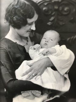


Pearl Brown Calvert
| Birth | : | 21 Sep 1907 Goucher, Cherokee County, South Carolina, USA |
| Death | : | 23 Dec 2005 Jonesville, Union County, South Carolina, USA |
| Burial | : | Denton Cemetery, Denton, Metropolitan Borough of Tameside, England |
| Coordinate | : | 53.4424140, -2.1115510 |
| Description | : | Pearl (Brown) Calvert, 98, of Jonesville, SC, widow of Jesse Leonard Calvert Jr., died at her home Friday, December 23, 2005. Mrs. Calvert was born in the Goucher Community of Cherokee County, September 21, 1907, a daughter of the late Jonathan Cleveland Brown and Eugenia (Burgess) Brown. She was the oldest member of Jonesville Baptist Church and a homemaker. Surviving are a daughter, Jean Calvert "Teeny" Collins and husband Jim of the home; five grandsons, Jim Collins Jr., and wife Karen of Birmingham, AL, Sam Collins of San Lorenzo, CA, Dr. Jeff Collins and wife Mitzi of Anniston, AL, Jonathan... Read More |
frequently asked questions (FAQ):
-
Where is Pearl Brown Calvert's memorial?
Pearl Brown Calvert's memorial is located at: Denton Cemetery, Denton, Metropolitan Borough of Tameside, England.
-
When did Pearl Brown Calvert death?
Pearl Brown Calvert death on 23 Dec 2005 in Jonesville, Union County, South Carolina, USA
-
Where are the coordinates of the Pearl Brown Calvert's memorial?
Latitude: 53.4424140
Longitude: -2.1115510
Family Members:
Parent

Spouse
Siblings
Children
Flowers:


Nearby Cemetories:
1. Denton Cemetery
Denton, Metropolitan Borough of Tameside, England
Coordinate: 53.4424140, -2.1115510
2. St Lawrence Church
Denton, Metropolitan Borough of Tameside, England
Coordinate: 53.4520000, -2.1109000
3. Christ Church Churchyard
Denton, Metropolitan Borough of Tameside, England
Coordinate: 53.4560270, -2.1218270
4. Saint Mark Churchyard
Bredbury, Metropolitan Borough of Stockport, England
Coordinate: 53.4241160, -2.1051390
5. St George Churchyard
Hyde, Metropolitan Borough of Tameside, England
Coordinate: 53.4466540, -2.0789750
6. Audenshaw Cemetery
Audenshaw, Metropolitan Borough of Tameside, England
Coordinate: 53.4653300, -2.1101560
7. Hyde Chapel Chapelyard
Gee Cross, Metropolitan Borough of Tameside, England
Coordinate: 53.4374900, -2.0728100
8. Hyde Cemetery
Hyde, Metropolitan Borough of Tameside, England
Coordinate: 53.4437910, -2.0684130
9. Saint Thomas The Apostle Churchyard
Hyde, Metropolitan Borough of Tameside, England
Coordinate: 53.4509000, -2.0707000
10. Holy Trinity Churchyard
Gee Cross, Metropolitan Borough of Tameside, England
Coordinate: 53.4393900, -2.0645500
11. Willow Grove Cemetery
Stockport, Metropolitan Borough of Stockport, England
Coordinate: 53.4252900, -2.1508100
12. Highfield Cemetery
Bredbury, Metropolitan Borough of Stockport, England
Coordinate: 53.4133310, -2.1111320
13. St. John The Baptist Churchyard
Hyde, Metropolitan Borough of Tameside, England
Coordinate: 53.4548411, -2.0644712
14. St Elisabeth Church
Reddish, Metropolitan Borough of Stockport, England
Coordinate: 53.4379400, -2.1633950
15. Saint Chad's Churchyard
Romiley, Metropolitan Borough of Stockport, England
Coordinate: 53.4128520, -2.0896350
16. Hatherlow Chapel Cemetery
Bredbury, Metropolitan Borough of Stockport, England
Coordinate: 53.4109259, -2.0992592
17. Hatherlow United Reformed Church Cemetery
Romiley, Metropolitan Borough of Stockport, England
Coordinate: 53.4107180, -2.0989830
18. Saint Stephens Churchyard
Audenshaw, Metropolitan Borough of Tameside, England
Coordinate: 53.4753000, -2.1151700
19. Gorton Cemetery
Manchester, Metropolitan Borough of Manchester, England
Coordinate: 53.4567080, -2.1632580
20. St Mary's Churchyard
Hyde, Metropolitan Borough of Tameside, England
Coordinate: 53.4652400, -2.0599700
21. Dukinfield Cemetery and Crematorium
Dukinfield, Metropolitan Borough of Tameside, England
Coordinate: 53.4800300, -2.0857150
22. The Parish Church of Saint Peter
Stockport, Metropolitan Borough of Stockport, England
Coordinate: 53.4084880, -2.1492930
23. St. Mary's Churchyard
Stockport, Metropolitan Borough of Stockport, England
Coordinate: 53.4112340, -2.1555140
24. St. Paul's Churchyard
Portwood, Metropolitan Borough of Stockport, England
Coordinate: 53.4215604, -2.1717953