
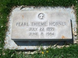
Pearl Mae McCormick Horner
| Birth | : | 22 Jul 1899 Mason City, Custer County, Nebraska, USA |
| Death | : | 8 Jun 1984 Alliance, Box Butte County, Nebraska, USA |
| Burial | : | Resurrection Cemetery, Wyoming, Kent County, USA |
| Coordinate | : | 42.8905983, -85.6819000 |
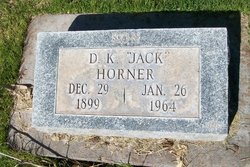
| Description | : | Mrs. Pearl Marie Horner of 416 Oak, died Friday in Alliance, Neb. She was 84. Closed casket funeral services will be conducted 11 a.m. Monday from Chaney Funeral Home, the Rev. Ivan E. Rundus D.D., officiating. Burial will follow in Riverside cemetery. Visitation at our chapel until 9 a.m., Monday. Mrs. Horner was born July 22, 1899 in Mason City, Neb., the daughter of Edward and Minnie Carmody Mccormick, received her schooling in Nebraska and the family moved to Sterling in 1914 where she married G.A. "Dutch" Thieme in 1919. He died in 1954 and in 1961 she married D.K. "Jack" Homer in Sterling. He... Read More |
frequently asked questions (FAQ):
-
Where is Pearl Mae McCormick Horner's memorial?
Pearl Mae McCormick Horner's memorial is located at: Resurrection Cemetery, Wyoming, Kent County, USA.
-
When did Pearl Mae McCormick Horner death?
Pearl Mae McCormick Horner death on 8 Jun 1984 in Alliance, Box Butte County, Nebraska, USA
-
Where are the coordinates of the Pearl Mae McCormick Horner's memorial?
Latitude: 42.8905983
Longitude: -85.6819000
Family Members:
Spouse
Children
Flowers:


Nearby Cemetories:
1. Resurrection Cemetery
Wyoming, Kent County, USA
Coordinate: 42.8905983, -85.6819000
2. Holy Trinity Columbarium
Wyoming, Kent County, USA
Coordinate: 42.8669010, -85.6847490
3. Rest Lawn Memorial Park
Grand Rapids, Kent County, USA
Coordinate: 42.9007988, -85.6438980
4. Pine Hill Cemetery
Kentwood, Kent County, USA
Coordinate: 42.8675003, -85.6363983
5. Oak Grove Cemetery
Grand Rapids, Kent County, USA
Coordinate: 42.9136009, -85.6314011
6. Woodlawn Cemetery
Grand Rapids, Kent County, USA
Coordinate: 42.9160995, -85.6303024
7. Maple Grove Cemetery
Kentwood, Kent County, USA
Coordinate: 42.9033300, -85.6203400
8. Garfield Park Cemetery
Grand Rapids, Kent County, USA
Coordinate: 42.9221992, -85.6307983
9. Grandville Cemetery
Grandville, Kent County, USA
Coordinate: 42.9043999, -85.7514038
10. Oakhill Cemetery
Grand Rapids, Kent County, USA
Coordinate: 42.9411011, -85.6517029
11. Kent Memorial Gardens
Byron Center, Kent County, USA
Coordinate: 42.8356018, -85.6883011
12. Sleepy Hollow Pet Cemetery and Crematory
Byron Center, Kent County, USA
Coordinate: 42.8477040, -85.7329940
13. Saint Andrews Catholic Cemetery
Grand Rapids, Kent County, USA
Coordinate: 42.9463997, -85.6567001
14. Blain Cemetery
Cutlerville, Kent County, USA
Coordinate: 42.8414001, -85.6335983
15. Grace Episcopal Church Columbarium
Grand Rapids, Kent County, USA
Coordinate: 42.9413390, -85.6242730
16. Winchester Cemetery
Byron Center, Kent County, USA
Coordinate: 42.8246994, -85.6980972
17. Boynton Cemetery
Byron Center, Kent County, USA
Coordinate: 42.8377991, -85.7433014
18. Westminster Presbyterian Church Columbarium
Grand Rapids, Kent County, USA
Coordinate: 42.9619070, -85.6646760
19. First United Methodist Church Columbarium
Grand Rapids, Kent County, USA
Coordinate: 42.9634200, -85.6633300
20. Central Reformed Church Crypt
Grand Rapids, Kent County, USA
Coordinate: 42.9634410, -85.6563430
21. Gerald R Ford Museum
Grand Rapids, Kent County, USA
Coordinate: 42.9668140, -85.6771000
22. Fulton Street Cemetery
Grand Rapids, Kent County, USA
Coordinate: 42.9639200, -85.6486400
23. River Bend Cemetery
Walker, Kent County, USA
Coordinate: 42.9352989, -85.7750015
24. Weaver Cemetery
Byron Township, Kent County, USA
Coordinate: 42.8041992, -85.6828003