
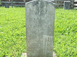
| Birth | : | 12 Mar 1822 Botetourt County, Virginia, USA |
| Death | : | 21 Feb 1905 Floyd County, Virginia, USA |
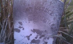
| Burial | : | Salmon Hole Cemetery, Lisbon, Grafton County, USA |
| Coordinate | : | 44.2359600, -71.8848200 |
| Description | : | Son of Christian Elder Bowman and Hannah Rinehart Bowman. Peter married Sarah Ann Spangler who is buried beside him. |
frequently asked questions (FAQ):
-
Where is Peter Bowman's memorial?
Peter Bowman's memorial is located at: Salmon Hole Cemetery, Lisbon, Grafton County, USA.
-
When did Peter Bowman death?
Peter Bowman death on 21 Feb 1905 in Floyd County, Virginia, USA
-
Where are the coordinates of the Peter Bowman's memorial?
Latitude: 44.2359600
Longitude: -71.8848200
Family Members:
Parent

Spouse
Siblings
Children
Flowers:


Nearby Cemetories:
1. Salmon Hole Cemetery
Lisbon, Grafton County, USA
Coordinate: 44.2359600, -71.8848200
2. Grove Hill Cemetery
Lisbon, Grafton County, USA
Coordinate: 44.2108002, -71.9094009
3. Pond Cemetery
Lyman, Grafton County, USA
Coordinate: 44.2671800, -71.9093700
4. Parker Hill Cemetery
Lyman, Grafton County, USA
Coordinate: 44.2582400, -71.9458800
5. Center Cemetery
Lyman, Grafton County, USA
Coordinate: 44.2672200, -71.9381400
6. Sunnyside Cemetery
Sugar Hill, Grafton County, USA
Coordinate: 44.2130300, -71.8061600
7. Landaff Center Cemetery
Landaff, Grafton County, USA
Coordinate: 44.1739860, -71.8847040
8. Pettyboro District Cemetery
Pettyboro, Grafton County, USA
Coordinate: 44.2038310, -71.9620880
9. Noyes Cemetery
Landaff, Grafton County, USA
Coordinate: 44.1830560, -71.8286110
10. Moulton Hill Cemetery
Lyman, Grafton County, USA
Coordinate: 44.2457400, -71.9862900
11. Bath Village Cemetery
Bath, Grafton County, USA
Coordinate: 44.1693500, -71.9617800
12. Ammonoosuc Meadows Cemetery
Littleton, Grafton County, USA
Coordinate: 44.3013992, -71.8043976
13. Upper Smith Road Cemetery
Bath, Grafton County, USA
Coordinate: 44.2202780, -72.0075000
14. Adams-Pfaelzer Cemetery
Littleton, Grafton County, USA
Coordinate: 44.3185210, -71.8283880
15. West Bath Cemetery
Bath, Grafton County, USA
Coordinate: 44.1750930, -71.9865080
16. Pattenville Cemetery (Defunct)
Littleton, Grafton County, USA
Coordinate: 44.3310320, -71.8624310
17. West Littleton Cemetery
Littleton, Grafton County, USA
Coordinate: 44.3319016, -71.9199982
18. Elmwood Cemetery
Franconia, Grafton County, USA
Coordinate: 44.2219009, -71.7474976
19. Saint Rose of Lima New Catholic Cemetery
Littleton, Grafton County, USA
Coordinate: 44.3130989, -71.7949982
20. Glenwood Cemetery
Littleton, Grafton County, USA
Coordinate: 44.3116100, -71.7901400
21. Willow Cemetery
Franconia, Grafton County, USA
Coordinate: 44.1968994, -71.7530975
22. Eli Wallace Horse Cemetery
Littleton, Grafton County, USA
Coordinate: 44.2981300, -71.7714081
23. North Monroe Cemetery
Monroe, Grafton County, USA
Coordinate: 44.3067680, -71.9998780
24. Riverside Cemetery
Waterford, Caledonia County, USA
Coordinate: 44.3456001, -71.8897018