
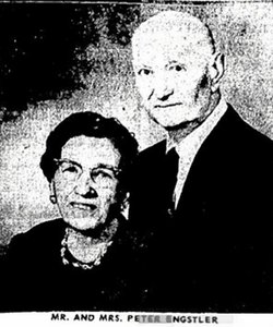
Peter Paul Engstler
| Birth | : | 19 Nov 1882 Marble Rock, Floyd County, Iowa, USA |
| Death | : | 10 Feb 1967 Britt, Hancock County, Iowa, USA |
| Burial | : | St. James' Cemetery, Bath, Bath and North East Somerset Unitary Authority, England |
| Coordinate | : | 51.3802000, -2.3722200 |
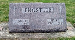
| Inscription | : | ENGSTLER Eunice G. 1892 - 1975 Peter P. 1882 - 1967 |
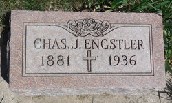
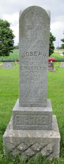
| Description | : | Extract from the 1900 Census: Name: Peter Engstler Age at last birthday: 17 Date of birth: Nov 1882 Birthplace: Iowa Race: white Sex: male Relationship to head-of-house: son Parents: Jacob and Catherine Engstler, ages 49 and 47 Home in 1900: Concord, Hancock, Iowa Marital status: single Father's birthplace: Germany Mother's birthplace: Germany Able to read, write and speak English: yes Father's occupation: farmer Occupation: farm laborer Months not employed: 0 Siblings living at home: John (age 22), Charlie J (10), Margaret (15), Joseph (14), Anna B (9), and Mary C (5) Census place: Concord, Hancock, Iowa; Roll: T623 434; Page:... Read More |
frequently asked questions (FAQ):
-
Where is Peter Paul Engstler's memorial?
Peter Paul Engstler's memorial is located at: St. James' Cemetery, Bath, Bath and North East Somerset Unitary Authority, England.
-
When did Peter Paul Engstler death?
Peter Paul Engstler death on 10 Feb 1967 in Britt, Hancock County, Iowa, USA
-
Where are the coordinates of the Peter Paul Engstler's memorial?
Latitude: 51.3802000
Longitude: -2.3722200
Family Members:
Parent

Spouse

Siblings
Children
Flowers:


Nearby Cemetories:
1. St. James' Cemetery
Bath, Bath and North East Somerset Unitary Authority, England
Coordinate: 51.3802000, -2.3722200
2. St Mary's Chapel, Queens Square
Bath, Bath and North East Somerset Unitary Authority, England
Coordinate: 51.3827790, -2.3649790
3. St Mary Magdalen Chapel
Widcombe, Bath and North East Somerset Unitary Authority, England
Coordinate: 51.3760486, -2.3643405
4. St James Old Burial Ground
Bath, Bath and North East Somerset Unitary Authority, England
Coordinate: 51.3798600, -2.3610100
5. Bath General Hospital Burial Ground
Bath and North East Somerset Unitary Authority, England
Coordinate: 51.3824715, -2.3614742
6. Twerton Cemetery
Twerton, Bath and North East Somerset Unitary Authority, England
Coordinate: 51.3802500, -2.3836220
7. Quaker Meeting House
Bath, Bath and North East Somerset Unitary Authority, England
Coordinate: 51.3823280, -2.3604380
8. St. Mary de Stall Churchyard (Defunct)
Bath, Bath and North East Somerset Unitary Authority, England
Coordinate: 51.3813350, -2.3600353
9. St. Michael's Cemetery
Bath, Bath and North East Somerset Unitary Authority, England
Coordinate: 51.3859700, -2.3814500
10. Ss Michael & Paul Churchyard
Bath, Bath and North East Somerset Unitary Authority, England
Coordinate: 51.3834970, -2.3596980
11. Bath Abbey
Bath, Bath and North East Somerset Unitary Authority, England
Coordinate: 51.3815310, -2.3586640
12. St. Michael's Burial Ground
Bath, Bath and North East Somerset Unitary Authority, England
Coordinate: 51.3838810, -2.3594090
13. Old Orchard Street Catholic Burial Vault
Bath, Bath and North East Somerset Unitary Authority, England
Coordinate: 51.3800370, -2.3579910
14. Locksbrook Cemetery
Lower Weston, Bath and North East Somerset Unitary Authority, England
Coordinate: 51.3845180, -2.3850300
15. Saint Mark's Churchyard
Widcombe, Bath and North East Somerset Unitary Authority, England
Coordinate: 51.3766660, -2.3588010
16. Moravian Burial Ground
Bath, Bath and North East Somerset Unitary Authority, England
Coordinate: 51.3894150, -2.3798150
17. Baptist Burial Ground
Widcombe, Bath and North East Somerset Unitary Authority, England
Coordinate: 51.3764216, -2.3556947
18. Locksbrook St Saviour's Cemetery
Bath and North East Somerset Unitary Authority, England
Coordinate: 51.3867880, -2.3863380
19. St. Swithin Churchyard
Bath, Bath and North East Somerset Unitary Authority, England
Coordinate: 51.3885480, -2.3594500
20. Abbey & St James' Graveyard for the Poor
Widcombe, Bath and North East Somerset Unitary Authority, England
Coordinate: 51.3753550, -2.3545640
21. Old Baptist Burial Ground
Walcot, Bath and North East Somerset Unitary Authority, England
Coordinate: 51.3755070, -2.3544360
22. Walcot Methodist Chapel Burial Ground
Bath, Bath and North East Somerset Unitary Authority, England
Coordinate: 51.3897080, -2.3579610
23. St. Mary's Churchyard
Bathwick, Bath and North East Somerset Unitary Authority, England
Coordinate: 51.3876120, -2.3543540
24. St. John the Baptist Churchyard
Bathwick, Bath and North East Somerset Unitary Authority, England
Coordinate: 51.3886890, -2.3547030