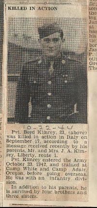
PFC Boyd Rayford Kimrey
| Birth | : | 14 Jul 1920 Randolph County, North Carolina, USA |
| Death | : | 17 Sep 1944 |
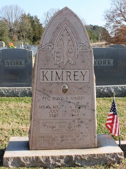
| Burial | : | Whites Chapel United Methodist Church Cemetery, Liberty, Randolph County, USA |
| Coordinate | : | 35.7850520, -79.6422990 |
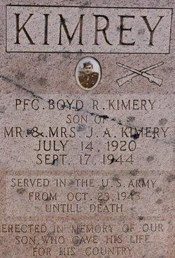
| Description | : | Son of Mr and Mrs J A Kimrey "Served in the US ARMY from OCT 23, 1943, until death. Erected n memory of our son who gave his life for his country." Father: James Alfred KIMREY Mother: Anna Belle KIRKMAN |
frequently asked questions (FAQ):
-
Where is PFC Boyd Rayford Kimrey's memorial?
PFC Boyd Rayford Kimrey's memorial is located at: Whites Chapel United Methodist Church Cemetery, Liberty, Randolph County, USA.
-
When did PFC Boyd Rayford Kimrey death?
PFC Boyd Rayford Kimrey death on 17 Sep 1944 in
-
Where are the coordinates of the PFC Boyd Rayford Kimrey's memorial?
Latitude: 35.7850520
Longitude: -79.6422990
Family Members:
Parent
Siblings
Flowers:

With honor and respect you are remembered today.
Left by Anonymous on 21 Apr 2013
Thank you for the ultimate sacrifice for our freedom...we honor and remember you dear soldier.
Left by Anonymous on 17 Aug 2017

Thank you for your heroism! You are not forgotten. Thank you for your heroism! You are not forgotten. His name is commemorated on the 363rd Infantry Regiment monument in Ponzalla, Italy.
Left by Anonymous on 30 Sep 2019
Nearby Cemetories:
1. Whites Chapel United Methodist Church Cemetery
Liberty, Randolph County, USA
Coordinate: 35.7850520, -79.6422990
2. Patterson Grove Christian Church Cemetery
Ramseur, Randolph County, USA
Coordinate: 35.7743940, -79.6536550
3. Hollys Chapel Pentecostal Holiness Church
Ramseur, Randolph County, USA
Coordinate: 35.7825600, -79.6048200
4. York Family Cemetery
Ramseur, Randolph County, USA
Coordinate: 35.7603000, -79.6108000
5. Cool Springs Baptist Church Cemetery
Franklinville, Randolph County, USA
Coordinate: 35.8072420, -79.6805660
6. Sandy Creek Baptist Church Cemetery
Liberty, Randolph County, USA
Coordinate: 35.8235550, -79.6429050
7. Friendship AME Church Cemetery
Ramseur, Randolph County, USA
Coordinate: 35.7463280, -79.6437970
8. Sandy Creek Primitive Baptist Church Cemetery
Liberty, Randolph County, USA
Coordinate: 35.8239020, -79.6406560
9. McMasters Cemetery
Randolph County, USA
Coordinate: 35.8072370, -79.6021500
10. Bible Truth Church Cemetery
Ramseur, Randolph County, USA
Coordinate: 35.7485370, -79.6204580
11. Shady Grove Baptist Church Cemetery
Staley, Randolph County, USA
Coordinate: 35.7853800, -79.5821020
12. Old Salem Cemetery
Franklinville, Randolph County, USA
Coordinate: 35.7414017, -79.6742020
13. First Baptist Church Cemetery
Franklinville, Randolph County, USA
Coordinate: 35.7482230, -79.6908630
14. Sunset Knoll Cemetery
Ramseur, Randolph County, USA
Coordinate: 35.7313995, -79.6500015
15. Ramseur Wesleyan Church Cemetery
Ramseur, Randolph County, USA
Coordinate: 35.7305670, -79.6593030
16. Grays Chapel Cemetery
Grays Chapel, Randolph County, USA
Coordinate: 35.8183570, -79.6986060
17. Old Shady Grove Cemetery
Staley, Randolph County, USA
Coordinate: 35.7874985, -79.5725021
18. Lineberry Family Cemetery
Staley, Randolph County, USA
Coordinate: 35.7878000, -79.5724000
19. Mount Pleasant Baptist Church Cemetery
Staley, Randolph County, USA
Coordinate: 35.8144700, -79.5790000
20. Whites Memorial Baptist Church Cemetery
Franklinville, Randolph County, USA
Coordinate: 35.7939680, -79.7149760
21. Melanchthon Lutheran Church Cemetery
Liberty, Randolph County, USA
Coordinate: 35.8451630, -79.6440640
22. Harmony Baptist Church Cemetery
Ramseur, Randolph County, USA
Coordinate: 35.7241680, -79.6418910
23. Franklinville United Methodist Church Cemetery
Franklinville, Randolph County, USA
Coordinate: 35.7462900, -79.7037500
24. Parks-Stout Cemetery
Randolph County, USA
Coordinate: 35.7205460, -79.6373740


