
| Birth | : | 27 Oct 1937 Stratford, Hamilton County, Iowa, USA |
| Death | : | 5 Apr 2017 Wathena, Doniphan County, Kansas, USA |
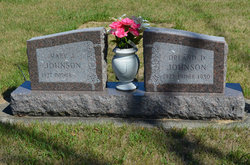
| Burial | : | South Marion Cemetery, Stratford, Hamilton County, USA |
| Coordinate | : | 42.2327995, -93.8735962 |
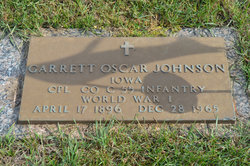
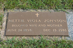
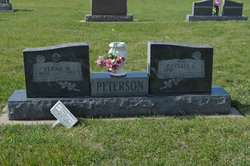
| Description | : | Wathena, Kansas - Phyllis C. Peterson, 79, of Wathena, Kansas passed away Wednesday, April 5, 2017. Phyllis was born on October 27, 1937 in Stratford, Iowa to Garrett O. & Nettie V. (Carlstedt) Johnson. She was a member of the Methodist Church, American Legion Auxiliary & the VFW Auxiliary all of Wathena. Phyllis worked as a sales clerk for the Millers & Nelson’s Pharmacy & the Wathena Times. Phyllis married Verne W. Peterson on November 4, 1956 at the Calvary United Methodist Church in Stratford, Iowa. He preceded her in death. She was also preceded in... Read More |
frequently asked questions (FAQ):
-
Where is Phyllis C. Johnson Peterson's memorial?
Phyllis C. Johnson Peterson's memorial is located at: South Marion Cemetery, Stratford, Hamilton County, USA.
-
When did Phyllis C. Johnson Peterson death?
Phyllis C. Johnson Peterson death on 5 Apr 2017 in Wathena, Doniphan County, Kansas, USA
-
Where are the coordinates of the Phyllis C. Johnson Peterson's memorial?
Latitude: 42.2327995
Longitude: -93.8735962
Family Members:
Parent
Spouse
Siblings
Flowers:


Nearby Cemetories:
1. South Marion Cemetery
Stratford, Hamilton County, USA
Coordinate: 42.2327995, -93.8735962
2. Oakwood Cemetery
Stratford, Hamilton County, USA
Coordinate: 42.2942009, -93.9182968
3. Mineral Ridge Cemetery
Ridgeport, Boone County, USA
Coordinate: 42.1749992, -93.9266968
4. Hooks Point Cemetery
Hamilton County, USA
Coordinate: 42.2944530, -93.9199090
5. Hardin Township Cemetery
Hardin Township, Webster County, USA
Coordinate: 42.2411003, -93.9708023
6. Saint Paul Lutheran Cemetery
Boone, Boone County, USA
Coordinate: 42.1700000, -93.8070000
7. Boone County Poor Farm Cemetery
Boone County, USA
Coordinate: 42.1591100, -93.9159000
8. White Cemetery
Boone County, USA
Coordinate: 42.1777992, -93.9636002
9. Lake Center Cemetery
Stanhope, Hamilton County, USA
Coordinate: 42.2482986, -93.7568970
10. Leininger Cemetery
Boone County, USA
Coordinate: 42.1492004, -93.8356018
11. Lawn Hill Cemetery
Stanhope, Hamilton County, USA
Coordinate: 42.2677994, -93.7611008
12. Nesse Cemetery
Hamilton County, USA
Coordinate: 42.3250008, -93.8933029
13. Neese Cemetery
Homer, Hamilton County, USA
Coordinate: 42.3250000, -93.8935000
14. Linn Cemetery
Pilot Mound, Boone County, USA
Coordinate: 42.2045330, -93.9970230
15. Vegors Cemetery
Webster County, USA
Coordinate: 42.3177986, -93.9421997
16. Mackey Cemetery
Boone County, USA
Coordinate: 42.1675000, -93.7565000
17. Runyan Cemetery
Pilot Mound, Boone County, USA
Coordinate: 42.1749992, -94.0015030
18. Saint Pauls Church Cemetery
Jewell, Hamilton County, USA
Coordinate: 42.2490100, -93.7173400
19. Schlicht Cemetery
Fraser, Boone County, USA
Coordinate: 42.1444200, -93.9780100
20. Bass Cemetery
Dayton, Webster County, USA
Coordinate: 42.2966995, -94.0149994
21. Saratoga Cemetery
Stanhope, Hamilton County, USA
Coordinate: 42.3539009, -93.8167038
22. Pilot Mound Cemetery
Pilot Mound, Boone County, USA
Coordinate: 42.1636200, -94.0282600
23. Ellsworth Clear Lake Cemetery
Randall, Hamilton County, USA
Coordinate: 42.2268930, -93.6926200
24. Bass Point Cemetery
Boone, Boone County, USA
Coordinate: 42.0992012, -93.8957977