
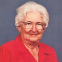
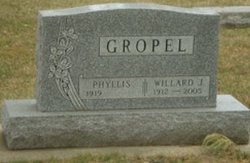
Phyllis Dephane Grim Gropel
| Birth | : | 26 Oct 1919 Olivet, Hutchinson County, South Dakota, USA |
| Death | : | 8 Jul 2012 Luverne, Rock County, Minnesota, USA |
| Burial | : | Greenwood Cemetery, Marion, Turner County, USA |
| Coordinate | : | 43.4150009, -97.2493973 |
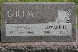
| Description | : | Phyllis Delphane Gropel passed away on July 8, 2012, at the Luverne Sanford Hospice Cottage, Luverne, Minnesota. She attained the age of 92 years, 8 months, and 12 days. Phyllis was born October 26, 1919, in Olivet, South Dakota, to Edward and Minnie Rebel Grim. She was the youngest of six children. She attended school in Olivet and Menno, graduating from Menno High School in 1937. Upon graduation, she enrolled in school at the South Dakota Beauty Academy, Sioux Falls, South Dakota, where she learned the trade of hair styling. Upon finishing school in Sioux Falls she went... Read More |
frequently asked questions (FAQ):
-
Where is Phyllis Dephane Grim Gropel's memorial?
Phyllis Dephane Grim Gropel's memorial is located at: Greenwood Cemetery, Marion, Turner County, USA.
-
When did Phyllis Dephane Grim Gropel death?
Phyllis Dephane Grim Gropel death on 8 Jul 2012 in Luverne, Rock County, Minnesota, USA
-
Where are the coordinates of the Phyllis Dephane Grim Gropel's memorial?
Latitude: 43.4150009
Longitude: -97.2493973
Family Members:
Parent

Spouse
Siblings
Children
Flowers:


Nearby Cemetories:
1. Greenwood Cemetery
Marion, Turner County, USA
Coordinate: 43.4150009, -97.2493973
2. Saint Marys Catholic Cemetery
Marion, Turner County, USA
Coordinate: 43.4371986, -97.2596970
3. Buller-Ensz Cemetery
Turner County, USA
Coordinate: 43.4186000, -97.2828500
4. First Church of God Cemetery
Marion, Turner County, USA
Coordinate: 43.4447000, -97.2727000
5. Tieszen Cemetery
Marion, Turner County, USA
Coordinate: 43.4219017, -97.3388977
6. Dick Cemetery
Turner County, USA
Coordinate: 43.4528008, -97.3319016
7. West Vermillion Cemetery
Marion, Turner County, USA
Coordinate: 43.4706001, -97.3189011
8. Saint Christina Cemetery
Parker, Turner County, USA
Coordinate: 43.3903008, -97.1502991
9. Rosehill Cemetery
Parker, Turner County, USA
Coordinate: 43.4117012, -97.1399994
10. Monroe Reformed Church Cemetery
McCook County, USA
Coordinate: 43.5004100, -97.2358170
11. Salem Zion Mennonite Cemetery
Turner County, USA
Coordinate: 43.3507996, -97.3296967
12. Turkey Valley Cemetery
Parker, Turner County, USA
Coordinate: 43.3280600, -97.2505500
13. Mennonite Cemetery
Dolton, Turner County, USA
Coordinate: 43.4472008, -97.3788986
14. Our Lady of Lourdes Catholic Cemetery
Dolton, Turner County, USA
Coordinate: 43.4871320, -97.3732960
15. Spring Valley Baptist Cemetery
Spring Valley Township, McCook County, USA
Coordinate: 43.5325920, -97.2290730
16. Salem Mennonite Church Cemetery
Turner County, USA
Coordinate: 43.3141890, -97.3364110
17. Bethany Cemetery
Hurley, Turner County, USA
Coordinate: 43.3003006, -97.1999969
18. Rose Hill Cemetery
McCook County, USA
Coordinate: 43.5119019, -97.3478012
19. Zion Cemetery
Hurley, Turner County, USA
Coordinate: 43.2994003, -97.2003021
20. Anna Koerner Burial Site
Hutchinson County, USA
Coordinate: 43.4290258, -97.4196065
21. Tschetter Cemetery
Freeman, Hutchinson County, USA
Coordinate: 43.3866997, -97.4197006
22. West Side Cemetery
Turner County, USA
Coordinate: 43.2849998, -97.2891998
23. Riverside Cemetery
Canistota, McCook County, USA
Coordinate: 43.5360985, -97.3283005
24. Adrian Cemetery
Freeman, Hutchinson County, USA
Coordinate: 43.4730320, -97.4196550