
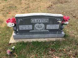
Phyllis Joan Tanner Clayton
| Birth | : | 9 Oct 1935 Doniphan, Ripley County, Missouri, USA |
| Death | : | 7 Aug 2014 West Plains, Howell County, Missouri, USA |
| Burial | : | Liberty Cemetery, Calm, Oregon County, USA |
| Coordinate | : | 36.5586500, -91.1549600 |
| Description | : | Phyllis Joan (Tanner) Clayton, age 78 of Gatewood, MO, was born October 9, 1935, in Doniphan, MO, and passed away August 7, 2014, at the Brookehaven Health Care in West Plains, MO. Survivors include: her husband, John Clayton; 2 daughters, Katherine White and Debbie Clayton; 6 grandchildren, Brandy Nichols, Amber Marshall, Greg Clayton, Johnny Clayton, Brandon Clayton, Bobby Clayton; 10 great-grandchildren; and numerous other relatives and friends. She was preceded in death by: her parents, Leamon and Gladys (Patterson) Tanner; 1 son, Dennis Clayton; and an infant sister. Funeral services will be 1pm Saturday, August 9, 2014, at the Liberty Church in Gatewood,... Read More |
frequently asked questions (FAQ):
-
Where is Phyllis Joan Tanner Clayton's memorial?
Phyllis Joan Tanner Clayton's memorial is located at: Liberty Cemetery, Calm, Oregon County, USA.
-
When did Phyllis Joan Tanner Clayton death?
Phyllis Joan Tanner Clayton death on 7 Aug 2014 in West Plains, Howell County, Missouri, USA
-
Where are the coordinates of the Phyllis Joan Tanner Clayton's memorial?
Latitude: 36.5586500
Longitude: -91.1549600
Family Members:
Parent

Spouse

Siblings
Children
Flowers:


Nearby Cemetories:
1. Liberty Cemetery
Calm, Oregon County, USA
Coordinate: 36.5586500, -91.1549600
2. Pigman Mound Archeological Site
Calm, Oregon County, USA
Coordinate: 36.5717100, -91.1784800
3. Pleasant Hill Cemetery
Calm, Oregon County, USA
Coordinate: 36.5950012, -91.1425018
4. Spring Valley Cemetery
Billmore, Oregon County, USA
Coordinate: 36.5324670, -91.2003420
5. Mount Carmel Cemetery
Calm, Oregon County, USA
Coordinate: 36.5106010, -91.1643982
6. Old Elmore Thomas field
Billmore, Oregon County, USA
Coordinate: 36.5237770, -91.1980250
7. Gatewood Cemetery
Gatewood, Ripley County, USA
Coordinate: 36.5751600, -91.0900900
8. New Home Cemetery
Tucker (Gatewood), Ripley County, USA
Coordinate: 36.5112100, -91.1089800
9. Tucker Cemetery
Tucker (Gatewood), Ripley County, USA
Coordinate: 36.5426417, -91.0757139
10. O'Neal
Billmore, Oregon County, USA
Coordinate: 36.5712170, -91.2415410
11. Dobbs Lahue Cemetery
Riverton, Oregon County, USA
Coordinate: 36.6269300, -91.1823600
12. Dobbs-LaHue Cemetery
Riverton, Oregon County, USA
Coordinate: 36.6233978, -91.1966476
13. Walnut Grove Cemetery
Elm Store, Randolph County, USA
Coordinate: 36.4914017, -91.1967010
14. Old Jobe Cemetery
Jobe, Oregon County, USA
Coordinate: 36.5917015, -91.2517014
15. Roberts Family Farm Cemetery
Couch, Oregon County, USA
Coordinate: 36.6165300, -91.2401700
16. Cotton Creek Cemetery
Jobe, Oregon County, USA
Coordinate: 36.5844002, -91.2652969
17. Coe Cemetery
Warm Springs, Randolph County, USA
Coordinate: 36.4732400, -91.1102200
18. Riverton Cemetery
Riverton, Oregon County, USA
Coordinate: 36.6476100, -91.2076900
19. Stubblefield Cemetery
Dalton, Randolph County, USA
Coordinate: 36.4597015, -91.1718979
20. Church of God Cemetery
Oregon County, USA
Coordinate: 36.5023500, -91.2580200
21. Myrtle Cemetery
Myrtle, Oregon County, USA
Coordinate: 36.5133900, -91.2664300
22. Boze Mill Cemetery
Boze Mill, Oregon County, USA
Coordinate: 36.6631126, -91.1940231
23. Macedonia Cemetery
Warm Springs, Randolph County, USA
Coordinate: 36.4707985, -91.0742035
24. Reynolds Cemetery
Elm Store, Randolph County, USA
Coordinate: 36.4491997, -91.1860962