
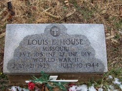

Pvt Louis E. “Bud” House
| Birth | : | 20 Jul 1923 Missouri, USA |
| Death | : | 10 Jul 1944 Saipan, Northern Mariana Islands |
| Burial | : | First Lutheran Cemetery, Plaza, Mountrail County, USA |
| Coordinate | : | 48.0374985, -101.9542007 |
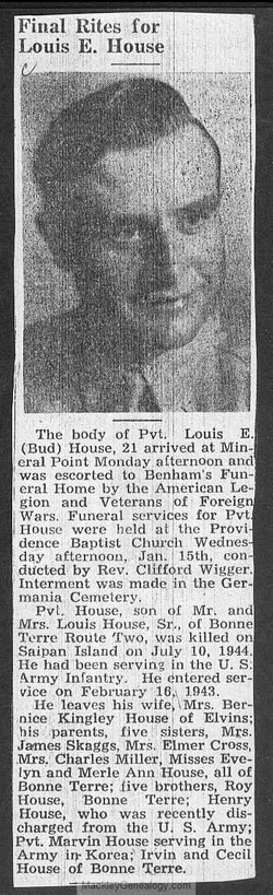
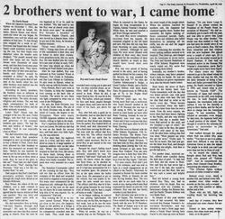
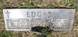
| Description | : | The Lead Belt News, January 7, 1949 BODY OF PVT. LOUIS E. HOUSE RE-BURIED AT GERMANIA Funeral services were conducted by Rev. Clifford Wigger at the Providence Church Wednesday afternoon at 2:00 o'clock for Pvt. Louis E. House, son of Mr. and Mrs. Louis E. House of Bonne Terre Route Two, who was killed in the battle of Saipan on July 10, 1944. Re-interment was in the Germania Cemetery with Benham Service. Pvt. House was born July 20, 1923 and died at the age of 21. He had served one and one-half years in the U.S. Infantry. Besides his parents, he leaves the following... Read More |
frequently asked questions (FAQ):
-
Where is Pvt Louis E. “Bud” House's memorial?
Pvt Louis E. “Bud” House's memorial is located at: First Lutheran Cemetery, Plaza, Mountrail County, USA.
-
When did Pvt Louis E. “Bud” House death?
Pvt Louis E. “Bud” House death on 10 Jul 1944 in Saipan, Northern Mariana Islands
-
Where are the coordinates of the Pvt Louis E. “Bud” House's memorial?
Latitude: 48.0374985
Longitude: -101.9542007
Family Members:
Parent
Siblings


Nearby Cemetories:
1. First Lutheran Cemetery
Plaza, Mountrail County, USA
Coordinate: 48.0374985, -101.9542007
2. East Community Cemetery
Plaza, Mountrail County, USA
Coordinate: 48.0243988, -101.9383011
3. Sacred Heart Cemetery
Plaza, Mountrail County, USA
Coordinate: 48.0139008, -101.9618988
4. Spring Valley Lutheran Cemetery
Ward County, USA
Coordinate: 48.0813000, -101.8785400
5. First Lutheran Wabek Cemetery
Wabek, Mountrail County, USA
Coordinate: 47.9633300, -101.9691000
6. Trinity Lutheran Cemetery
Plaza, Mountrail County, USA
Coordinate: 48.1385307, -102.0082397
7. Saint Elizabeth Catholic Cemetery
Makoti, Ward County, USA
Coordinate: 47.9773600, -101.8074600
8. Hope Lutheran Cemetery
Makoti, Ward County, USA
Coordinate: 47.9637070, -101.7867420
9. Saint Bridgets Cemetery
Parshall, Mountrail County, USA
Coordinate: 47.9622700, -102.1328910
10. Johns Cemetery
Mountrail County, USA
Coordinate: 48.1055984, -102.1461029
11. Bethlehem Lutheran Cemetery
Belden, Mountrail County, USA
Coordinate: 48.0307007, -102.1838989
12. Parshall Cemetery
Parshall, Mountrail County, USA
Coordinate: 47.9357200, -102.1282000
13. Saint Pauls Lutheran Cemetery
Makoti, Ward County, USA
Coordinate: 47.9057560, -101.8191380
14. Shell Creek Lutheran Cemetery
Blaisdell, Mountrail County, USA
Coordinate: 48.2117577, -102.0525131
15. Rolling Prairie Cemetery
Tagus, Mountrail County, USA
Coordinate: 48.2329000, -101.9767500
16. Epworth Cemetery
Mountrail County, USA
Coordinate: 48.1258011, -102.2174988
17. Hiland Cemetery
Ryder, Ward County, USA
Coordinate: 48.0729103, -101.6588669
18. Lucky Mound Lutheran Cemetery
McLean County, USA
Coordinate: 47.8338990, -102.0010640
19. Rosehill Cemetery
Ryder, Ward County, USA
Coordinate: 47.9266600, -101.6706500
20. Anna Township Cemetery
Makoti, Ward County, USA
Coordinate: 48.0199410, -101.6152740
21. Hiddenwood Cemetery
McLean County, USA
Coordinate: 47.8330994, -101.7743988
22. Church of God Cemetery
Raub, McLean County, USA
Coordinate: 47.8041344, -102.0656662
23. Bethany Cemetery
Belden, Mountrail County, USA
Coordinate: 48.1608009, -102.2917023
24. Emrich Cemetery
Roseglen, McLean County, USA
Coordinate: 47.7947180, -101.8082670