

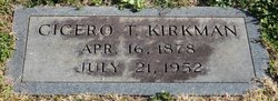
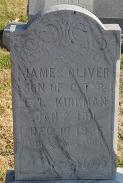
Pvt Richard Woodrow Kirkman
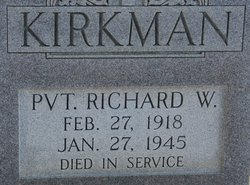
| Birth | : | 27 Feb 1918 |
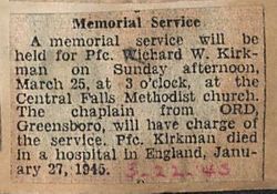
| Death | : | 27 Jan 1945 England |
| Burial | : | Whites Chapel United Methodist Church Cemetery, Liberty, Randolph County, USA |
| Coordinate | : | 35.7850520, -79.6422990 |
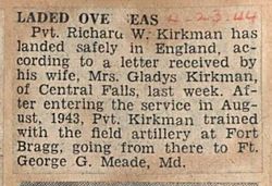
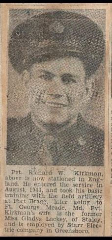
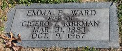
| Description | : | PFC RICHARD W. KIRKMAN SUCCUMBS IN ENGLAND ASHEBORO, Feb. 15 - Pfc Richard W. Kirkman, Field Artillery, son of Mr. and Mrs. C. T. Kirkman of Liberty, Route, died January 27 in a hospital in England, of liver trouble, according to word received by his wife who lives at Staley. Pvt. Kirkman, who formerly lived in Central Falls, had been in the service since August, 1943, and was overseas about eight months, in France and Germany. He was injured in Europe last autumn. Surviving, besides his widow and parents are four sisters, Mrs. E. D. Poe of... Read More |
frequently asked questions (FAQ):
-
Where is Pvt Richard Woodrow Kirkman's memorial?
Pvt Richard Woodrow Kirkman's memorial is located at: Whites Chapel United Methodist Church Cemetery, Liberty, Randolph County, USA.
-
When did Pvt Richard Woodrow Kirkman death?
Pvt Richard Woodrow Kirkman death on 27 Jan 1945 in England
-
Where are the coordinates of the Pvt Richard Woodrow Kirkman's memorial?
Latitude: 35.7850520
Longitude: -79.6422990
Family Members:
Parent
Spouse
Siblings

Flowers:


Nearby Cemetories:
1. Whites Chapel United Methodist Church Cemetery
Liberty, Randolph County, USA
Coordinate: 35.7850520, -79.6422990
2. Patterson Grove Christian Church Cemetery
Ramseur, Randolph County, USA
Coordinate: 35.7743940, -79.6536550
3. Hollys Chapel Pentecostal Holiness Church
Ramseur, Randolph County, USA
Coordinate: 35.7825600, -79.6048200
4. York Family Cemetery
Ramseur, Randolph County, USA
Coordinate: 35.7603000, -79.6108000
5. Cool Springs Baptist Church Cemetery
Franklinville, Randolph County, USA
Coordinate: 35.8072420, -79.6805660
6. Sandy Creek Baptist Church Cemetery
Liberty, Randolph County, USA
Coordinate: 35.8235550, -79.6429050
7. Friendship AME Church Cemetery
Ramseur, Randolph County, USA
Coordinate: 35.7463280, -79.6437970
8. Sandy Creek Primitive Baptist Church Cemetery
Liberty, Randolph County, USA
Coordinate: 35.8239020, -79.6406560
9. McMasters Cemetery
Randolph County, USA
Coordinate: 35.8072370, -79.6021500
10. Bible Truth Church Cemetery
Ramseur, Randolph County, USA
Coordinate: 35.7485370, -79.6204580
11. Shady Grove Baptist Church Cemetery
Staley, Randolph County, USA
Coordinate: 35.7853800, -79.5821020
12. Old Salem Cemetery
Franklinville, Randolph County, USA
Coordinate: 35.7414017, -79.6742020
13. First Baptist Church Cemetery
Franklinville, Randolph County, USA
Coordinate: 35.7482230, -79.6908630
14. Sunset Knoll Cemetery
Ramseur, Randolph County, USA
Coordinate: 35.7313995, -79.6500015
15. Ramseur Wesleyan Church Cemetery
Ramseur, Randolph County, USA
Coordinate: 35.7305670, -79.6593030
16. Grays Chapel Cemetery
Grays Chapel, Randolph County, USA
Coordinate: 35.8183570, -79.6986060
17. Old Shady Grove Cemetery
Staley, Randolph County, USA
Coordinate: 35.7874985, -79.5725021
18. Lineberry Family Cemetery
Staley, Randolph County, USA
Coordinate: 35.7878000, -79.5724000
19. Mount Pleasant Baptist Church Cemetery
Staley, Randolph County, USA
Coordinate: 35.8144700, -79.5790000
20. Whites Memorial Baptist Church Cemetery
Franklinville, Randolph County, USA
Coordinate: 35.7939680, -79.7149760
21. Melanchthon Lutheran Church Cemetery
Liberty, Randolph County, USA
Coordinate: 35.8451630, -79.6440640
22. Harmony Baptist Church Cemetery
Ramseur, Randolph County, USA
Coordinate: 35.7241680, -79.6418910
23. Franklinville United Methodist Church Cemetery
Franklinville, Randolph County, USA
Coordinate: 35.7462900, -79.7037500
24. Parks-Stout Cemetery
Randolph County, USA
Coordinate: 35.7205460, -79.6373740