
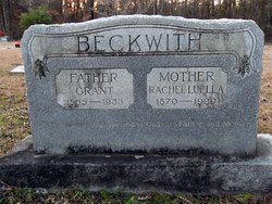
Rachel Luella Potter Beckwith
| Birth | : | 17 May 1870 Brandon Township, Jackson County, Iowa, USA |
| Death | : | 16 Jun 1929 Rison, Cleveland County, Arkansas, USA |
| Burial | : | Saint Peters Churchyard, Freshford, Bath and North East Somerset Unitary Authority, England |
| Coordinate | : | 51.3400570, -2.3033340 |
| Description | : | CLEVELAND COUNTY HERALD June 20, 1929 MRS. GRANT BECKWITH Mrs. Rachel Luella Beckwith, aged 62, wife of Grant Beckwith, well-known farmer and dairyman who resides three miles northwest of Rison, died at her home Sunday night following an illness of two weeks. She had been in ill health for several months. Mrs. Beckwith was born in Jackson county, Iowa, May 17, 1867. At the age of 15 she united with the Methodist church. In 1886 she was married to Mr. Beckwith, moving to this county about 18 years ago. During her residence here she has made many friends who mourn her passing.... Read More |
frequently asked questions (FAQ):
-
Where is Rachel Luella Potter Beckwith's memorial?
Rachel Luella Potter Beckwith's memorial is located at: Saint Peters Churchyard, Freshford, Bath and North East Somerset Unitary Authority, England.
-
When did Rachel Luella Potter Beckwith death?
Rachel Luella Potter Beckwith death on 16 Jun 1929 in Rison, Cleveland County, Arkansas, USA
-
Where are the coordinates of the Rachel Luella Potter Beckwith's memorial?
Latitude: 51.3400570
Longitude: -2.3033340
Family Members:
Parent

Spouse

Siblings
Children
Flowers:


Nearby Cemetories:
1. Saint Peters Churchyard
Freshford, Bath and North East Somerset Unitary Authority, England
Coordinate: 51.3400570, -2.3033340
2. Freshford Cemetery
Freshford, Bath and North East Somerset Unitary Authority, England
Coordinate: 51.3379620, -2.3082970
3. St. John the Baptist Churchyard
Hinton Charterhouse, Bath and North East Somerset Unitary Authority, England
Coordinate: 51.3233330, -2.3219440
4. Midford Burial Ground
Bath, Bath and North East Somerset Unitary Authority, England
Coordinate: 51.3394360, -2.3391424
5. St. Michael's Churchyard
Monkton Combe, Bath and North East Somerset Unitary Authority, England
Coordinate: 51.3559540, -2.3285700
6. Farleigh Hungerford Castle
Farleigh Hungerford, Mendip District, England
Coordinate: 51.3173500, -2.2869590
7. St Leonard Churchyard
Farleigh Hungerford, Mendip District, England
Coordinate: 51.3155390, -2.2884820
8. Holy Trinity Churchyard
Bradford-on-Avon, Wiltshire Unitary Authority, England
Coordinate: 51.3465927, -2.2538147
9. Union Chapel
Combe Down, Bath and North East Somerset Unitary Authority, England
Coordinate: 51.3594751, -2.3443662
10. Christ Church Churchyard
Bradford-on-Avon, Wiltshire Unitary Authority, England
Coordinate: 51.3507000, -2.2493360
11. Prior Park College
Bath, Bath and North East Somerset Unitary Authority, England
Coordinate: 51.3645990, -2.3442400
12. St. Mary's Churchyard
Claverton, Bath and North East Somerset Unitary Authority, England
Coordinate: 51.3757560, -2.3061500
13. Claverton Cemetery
Bath, Bath and North East Somerset Unitary Authority, England
Coordinate: 51.3758190, -2.3060720
14. Jewish Burial Ground
Combe Down, Bath and North East Somerset Unitary Authority, England
Coordinate: 51.3599170, -2.3534670
15. St. James' Churchyard
South Stoke, Bath and North East Somerset Unitary Authority, England
Coordinate: 51.3497220, -2.3652780
16. St John the Evangelist Cemetery
Bath, Bath and North East Somerset Unitary Authority, England
Coordinate: 51.3696700, -2.3487400
17. All Saints Churchyard
Tellisford, Mendip District, England
Coordinate: 51.2997270, -2.2877180
18. Bath Abbey Cemetery
Widcombe, Bath and North East Somerset Unitary Authority, England
Coordinate: 51.3712850, -2.3483060
19. Norton St. Philip Churchyard
Norton St Philip, Mendip District, England
Coordinate: 51.3001680, -2.3279700
20. St Thomas à Becket's Church
Widcombe, Bath and North East Somerset Unitary Authority, England
Coordinate: 51.3734250, -2.3465560
21. St. Mary The Virgin Churchyard
Bathwick, Bath and North East Somerset Unitary Authority, England
Coordinate: 51.3759930, -2.3411930
22. Holt Cemetery
Bradford-on-Avon, Wiltshire Unitary Authority, England
Coordinate: 51.3468710, -2.2352160
23. Smallcombe Vale Cemetery
Bathwick, Bath and North East Somerset Unitary Authority, England
Coordinate: 51.3757400, -2.3429400
24. Unitarian Chapel Burial Ground
Widcombe, Bath and North East Somerset Unitary Authority, England
Coordinate: 51.3704650, -2.3539270