
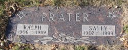
Ralph Everett Prater
| Birth | : | 27 Feb 1906 Endicott, Whitman County, Washington, USA |
| Death | : | 14 Feb 1989 Big Sandy, Chouteau County, Montana, USA |
| Burial | : | Netherlands American Cemetery and Memorial, Margraten, Eijsden-Margraten Municipality, Netherlands |
| Coordinate | : | 50.8176918, 5.8046441 |
| Description | : | Obit from Find A Grave contributor "Cara": The Mountaineer, Big Sandy, MT, 23 Feb 1989 (excerpt) Ralph Everett Prater, 82, died Feb. 14, 1989, at the Big Sandy Medical Center following a long illness. Ralph was born February 27, 1906 to Mr. and Mrs. R.J. Prater in Endicott, WA. When he was six years old he moved with his family to Big Sandy where they settled on Lonesome Prairie. He remembered how cold it was when they arrived by train, and his father was ill with the flu so a neighbor came to get them in a wagon.... Read More |
frequently asked questions (FAQ):
-
Where is Ralph Everett Prater's memorial?
Ralph Everett Prater's memorial is located at: Netherlands American Cemetery and Memorial, Margraten, Eijsden-Margraten Municipality, Netherlands.
-
When did Ralph Everett Prater death?
Ralph Everett Prater death on 14 Feb 1989 in Big Sandy, Chouteau County, Montana, USA
-
Where are the coordinates of the Ralph Everett Prater's memorial?
Latitude: 50.8176918
Longitude: 5.8046441
Family Members:
Parent

Spouse

Siblings
Flowers:


Nearby Cemetories:
1. Netherlands American Cemetery and Memorial
Margraten, Eijsden-Margraten Municipality, Netherlands
Coordinate: 50.8176918, 5.8046441
2. Cadier en Keer Kerkhof
Cadier en Keer, Eijsden-Margraten Municipality, Netherlands
Coordinate: 50.8268600, 5.7695500
3. Begraafplaats Banholt
Banholt, Eijsden-Margraten Municipality, Netherlands
Coordinate: 50.7911800, 5.8139700
4. Reijmerstok Begraafplaats
Reijmerstok, Gulpen-Wittem Municipality, Netherlands
Coordinate: 50.7994500, 5.8407600
5. Algemene Begraafplaats
Valkenburg, Valkenburg aan de Geul Municipality, Netherlands
Coordinate: 50.8611100, 5.8248500
6. Oude Joodse Begraafplaats
Valkenburg, Valkenburg aan de Geul Municipality, Netherlands
Coordinate: 50.8613900, 5.8314100
7. Zusterbegraafplaats Rijckholt
Rijckholt, Eijsden-Margraten Municipality, Netherlands
Coordinate: 50.7961186, 5.7328002
8. Joodse Begraafplaats
Gulpen, Gulpen-Wittem Municipality, Netherlands
Coordinate: 50.8135290, 5.8865910
9. Wijlre Kerkhof
Wijlre, Gulpen-Wittem Municipality, Netherlands
Coordinate: 50.8315400, 5.8945100
10. Maastricht Oostermaas Cemetery
Maastricht, Maastricht Municipality, Netherlands
Coordinate: 50.8533700, 5.7224900
11. Begraafplaats Katholieke Kerk Heugem
Maastricht, Maastricht Municipality, Netherlands
Coordinate: 50.8315572, 5.7026935
12. Sint-Martens-Voeren Churchyard
Voeren, Arrondissement Tongeren, Belgium
Coordinate: 50.7492100, 5.8127200
13. Joodse Begraafplaats
Schimmert, Nuth Municipality, Netherlands
Coordinate: 50.8875400, 5.8149000
14. Kerkhof van Sint Pieter Op de Berg
Sint Pieter, Maastricht Municipality, Netherlands
Coordinate: 50.8313511, 5.6929176
15. Joodse Begraafplaats Meerssen
Meerssen Municipality, Netherlands
Coordinate: 50.8800900, 5.7473400
16. Joodse Begraafplaats
Eijsden-Margraten Municipality, Netherlands
Coordinate: 50.7760600, 5.7065700
17. Lanaye Communal Cemetery
Visé, Arrondissement de Liège, Belgium
Coordinate: 50.7819100, 5.6966500
18. Begraafplaats R.K. Parochie H Remigius
Klimmen, Voerendaal Municipality, Netherlands
Coordinate: 50.8764108, 5.8855418
19. Mechelen Kerkhof Cemetery
Mechelen, Gulpen-Wittem Municipality, Netherlands
Coordinate: 50.7964000, 5.9256700
20. Kanne Cemetery
Riemst, Arrondissement Tongeren, Belgium
Coordinate: 50.8143100, 5.6774900
21. Basiliek van Sint Servaas
Maastricht, Maastricht Municipality, Netherlands
Coordinate: 50.8487670, 5.6871100
22. Mechelen Kerk Begraafplaats apex
Mechelen, Gulpen-Wittem Municipality, Netherlands
Coordinate: 50.7981500, 5.9282700
23. R.K. Begraafplaats
Eys, Gulpen-Wittem Municipality, Netherlands
Coordinate: 50.8260056, 5.9327850
24. Belgische Oorlogsbegraafplaats Kanne
Riemst, Arrondissement Tongeren, Belgium
Coordinate: 50.8101400, 5.6682500