
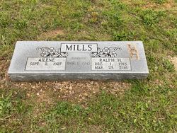

Ralph Harold Mills
| Birth | : | 1 Dec 1918 Thayer, Oregon County, Missouri, USA |
| Death | : | 23 Mar 2011 West Plains, Howell County, Missouri, USA |
| Burial | : | New Salem Cemetery, Couch, Oregon County, USA |
| Coordinate | : | 36.6042252, -91.3712463 |
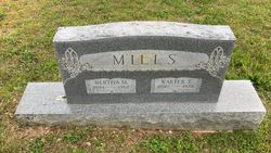
| Description | : | Ralph Harold Mills was born the son of Walter Thomas Mills and Bertha Mae Strain Mills on December 1, 1918 at Thayer, Missouri and departed this life March 23, 2011 in West Plains, Missouri at the age of 92 years. He was united in marriage March 1, 1945 in Thayer, Missouri to Ailene Ridenhour. He is survived by his wife, Ailene of the home in West Plains, Missouri; four children, Sandra Mills of West Plains, Missouri, Randolph Mills of Imperial, Missouri, Bradley Mills and wife, Janet of West Plains, Missouri and Rosemary Hendon and husband, Kenneth of West Plains, Missouri; three grandchildren,... Read More |
frequently asked questions (FAQ):
-
Where is Ralph Harold Mills's memorial?
Ralph Harold Mills's memorial is located at: New Salem Cemetery, Couch, Oregon County, USA.
-
When did Ralph Harold Mills death?
Ralph Harold Mills death on 23 Mar 2011 in West Plains, Howell County, Missouri, USA
-
Where are the coordinates of the Ralph Harold Mills's memorial?
Latitude: 36.6042252
Longitude: -91.3712463
Family Members:
Parent

Siblings
Flowers:


Nearby Cemetories:
1. New Salem Cemetery
Couch, Oregon County, USA
Coordinate: 36.6042252, -91.3712463
2. Olon Tucker Farm Cemetery #2
Couch, Oregon County, USA
Coordinate: 36.5867000, -91.3705400
3. Baker Cemetery
Couch, Oregon County, USA
Coordinate: 36.6248283, -91.3932877
4. Garfield Cemetery
Garfield, Oregon County, USA
Coordinate: 36.5844400, -91.3253400
5. Cave Springs Cemetery #2
Alton, Oregon County, USA
Coordinate: 36.6488900, -91.3652900
6. Cave Springs Cemetery
Alton, Oregon County, USA
Coordinate: 36.6492004, -91.3655014
7. Crabb Cemetery
Couch, Oregon County, USA
Coordinate: 36.5988541, -91.4339752
8. Arytown Cemetery
Arytown, Oregon County, USA
Coordinate: 36.5539513, -91.3795776
9. Bonds Cemetery
Couch, Oregon County, USA
Coordinate: 36.5989914, -91.4346619
10. Russell Cemetery
Couch, Oregon County, USA
Coordinate: 36.5506477, -91.3991928
11. Adolph Ostrom Farm Cemetery
Thayer, Oregon County, USA
Coordinate: 36.5788160, -91.4426640
12. Guiteau-Risner Cemetery
Guiteau, Oregon County, USA
Coordinate: 36.5588074, -91.3156128
13. Norman Cemetery
Alton, Oregon County, USA
Coordinate: 36.6143990, -91.4499969
14. John Brown Cemetery
Jobe, Oregon County, USA
Coordinate: 36.5812111, -91.2953568
15. Copenhagen Cemetery
Couch, Oregon County, USA
Coordinate: 36.6347421, -91.4460619
16. Copenhagen Family Cemetery
Alton, Oregon County, USA
Coordinate: 36.6369684, -91.4464551
17. Crass Homestead
Myrtle, Oregon County, USA
Coordinate: 36.5359695, -91.3084671
18. Old Culp Place
Alton, Oregon County, USA
Coordinate: 36.6892400, -91.3760600
19. Lance Cemetery
Many Springs, Oregon County, USA
Coordinate: 36.6310997, -91.2699966
20. Midway Cemetery
Couch, Oregon County, USA
Coordinate: 36.6031690, -91.4788520
21. Cotton Creek Cemetery
Jobe, Oregon County, USA
Coordinate: 36.5844002, -91.2652969
22. Dills Cemetery
Alton, Oregon County, USA
Coordinate: 36.6596985, -91.4586029
23. Alton City Cemetery
Alton, Oregon County, USA
Coordinate: 36.6918983, -91.3982010
24. Many Springs Cemetery
Many Springs, Oregon County, USA
Coordinate: 36.6521200, -91.2695100