
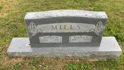
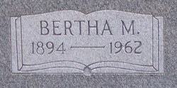
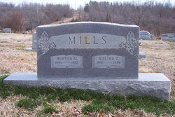
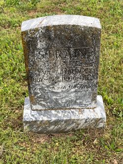
Bertha May Strain Mills
| Birth | : | 19 Dec 1894 Couch, Oregon County, Missouri, USA |
| Death | : | 4 May 1962 Oregon County, Missouri, USA |
| Burial | : | Pleasant Hill Cemetery, Berne Township, Fairfield County, USA |
| Coordinate | : | 39.6717239, -82.5084873 |
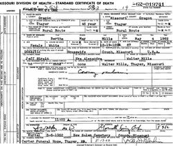
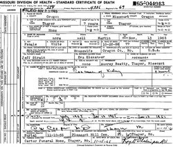
| Description | : | Daughter of Thomas 'Jeff' Jefferson Strain, III and Eva Belle (Alexander) Strain. Married Walter Thomas Mills 07/Apr/1914 at Alton, MO. Home maker. Per MO Death certificate #62-019741; burial 06/May/1962. NOTE: 1900 census has birth as Jan 1895. |
frequently asked questions (FAQ):
-
Where is Bertha May Strain Mills's memorial?
Bertha May Strain Mills's memorial is located at: Pleasant Hill Cemetery, Berne Township, Fairfield County, USA.
-
When did Bertha May Strain Mills death?
Bertha May Strain Mills death on 4 May 1962 in Oregon County, Missouri, USA
-
Where are the coordinates of the Bertha May Strain Mills's memorial?
Latitude: 39.6717239
Longitude: -82.5084873
Family Members:
Parent

Spouse

Siblings
Children
Flowers:


Nearby Cemetories:
1. Pleasant Hill Cemetery
Berne Township, Fairfield County, USA
Coordinate: 39.6717239, -82.5084873
2. Saint Paul Lutheran Cemetery
North Berne, Fairfield County, USA
Coordinate: 39.6913400, -82.5164000
3. Phillips Cemetery
Horns Mill, Fairfield County, USA
Coordinate: 39.6475640, -82.5144030
4. Focht Cemetery
Rush Creek Township, Fairfield County, USA
Coordinate: 39.6704990, -82.4590440
5. Crawfis-Emery Cemetery
Lancaster, Fairfield County, USA
Coordinate: 39.6787000, -82.5580000
6. Collins Chapel Cemetery
Fairfield County, USA
Coordinate: 39.7097015, -82.4961014
7. Friesner Cemetery
Bremen, Fairfield County, USA
Coordinate: 39.6874420, -82.4616020
8. Ream Cemetery
Sugar Grove, Fairfield County, USA
Coordinate: 39.6513610, -82.5546500
9. New Olive Branch Cemetery
Bremen, Fairfield County, USA
Coordinate: 39.6892900, -82.4587700
10. Saint Emanuel Lutheran Cemetery
Marion Township, Hocking County, USA
Coordinate: 39.6433900, -82.4628000
11. Saint Jacobus Evangelical Lutheran Cemetery
Hideaway Hills, Hocking County, USA
Coordinate: 39.6434700, -82.4607900
12. Baron-Graham Family Cemetery
Hideaway Hills, Hocking County, USA
Coordinate: 39.6385070, -82.4657110
13. Zwingley Cemetery
Fairfield County, USA
Coordinate: 39.6735992, -82.4475021
14. Mount Zion Cemetery
Bremen, Fairfield County, USA
Coordinate: 39.7075005, -82.4666977
15. Casper Hufford Cemetery
Lancaster, Fairfield County, USA
Coordinate: 39.7196198, -82.4976425
16. Mount Tabor Cemetery
Fairfield County, USA
Coordinate: 39.7205000, -82.5174330
17. Bibler Cemetery
Fairfield County, USA
Coordinate: 39.7214012, -82.5081024
18. Amish Mennonite Cemetery
Lancaster, Fairfield County, USA
Coordinate: 39.7218610, -82.5035470
19. Driver Cemetery
Bremen, Fairfield County, USA
Coordinate: 39.7144012, -82.4721985
20. Stukey Cemetery
Fairfield County, USA
Coordinate: 39.6343994, -82.5558014
21. Lamott Cemetery
Fairfield County, USA
Coordinate: 39.6931590, -82.5743200
22. Applegate Cemetery
Lancaster, Fairfield County, USA
Coordinate: 39.7202988, -82.5421982
23. Friesner Cemetery
Lancaster, Fairfield County, USA
Coordinate: 39.7252998, -82.5258026
24. Maple Grove Cemetery
Lancaster, Fairfield County, USA
Coordinate: 39.7266998, -82.5186005