
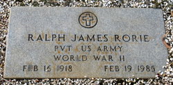


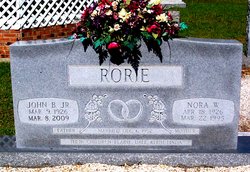
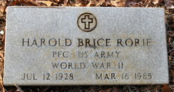
Ralph James Rorie
| Birth | : | 16 Feb 1918 |
| Death | : | 19 Feb 1985 |
| Burial | : | Gallup State Veterans Cemetery, Gallup, McKinley County, USA |
| Coordinate | : | 35.5358950, -108.7086870 |
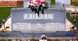
| Description | : | PVT US ARMY WWII CHILDREN: KAY, MELODY, PEGGY, PENNY Father's Name: John B. Rorie Mother's Name: Gertrude Melton |
frequently asked questions (FAQ):
-
Where is Ralph James Rorie's memorial?
Ralph James Rorie's memorial is located at: Gallup State Veterans Cemetery, Gallup, McKinley County, USA.
-
When did Ralph James Rorie death?
Ralph James Rorie death on 19 Feb 1985 in
-
Where are the coordinates of the Ralph James Rorie's memorial?
Latitude: 35.5358950
Longitude: -108.7086870
Family Members:
Parent

Spouse
Siblings


Flowers:


Nearby Cemetories:
1. Gallup State Veterans Cemetery
Gallup, McKinley County, USA
Coordinate: 35.5358950, -108.7086870
2. Cathedral of the Sacred Heart Crypt
Gallup, McKinley County, USA
Coordinate: 35.5258450, -108.7357330
3. Hillcrest Cemetery
Gallup, McKinley County, USA
Coordinate: 35.5214005, -108.7525024
4. Rehoboth Mission Cemetery
Rehoboth, McKinley County, USA
Coordinate: 35.5286640, -108.6540990
5. Gallup City Cemetery
Gallup, McKinley County, USA
Coordinate: 35.5016320, -108.8400220
6. Sunset Memorial Park
Gallup, McKinley County, USA
Coordinate: 35.5028770, -108.8443640
7. Pinehaven Cemetery
Pinehaven, McKinley County, USA
Coordinate: 35.3518982, -108.7268982
8. Torreon Cemetery
McKinley County, USA
Coordinate: 35.3722000, -108.5250015
9. Pinedale Cemetery
Pinedale, McKinley County, USA
Coordinate: 35.6113860, -108.4498390
10. McGaffey Cemetery
McGaffey, McKinley County, USA
Coordinate: 35.3703003, -108.5224991
11. Pine Tree Cemetery
Vanderwagen, McKinley County, USA
Coordinate: 35.2658410, -108.7540080
12. Lone Pine Cemetery
Mexican Springs, McKinley County, USA
Coordinate: 35.8258018, -108.8771973
13. Tohatchi Cemetery
Tohatchi, McKinley County, USA
Coordinate: 35.8626080, -108.7582670
14. Saint Michaels Cemetery
Saint Michaels, Apache County, USA
Coordinate: 35.6431900, -109.0986900
15. Navajo Veterans Cemetery
Fort Defiance, Apache County, USA
Coordinate: 35.7226600, -109.0553390
16. Family Cemeteries
Apache County, USA
Coordinate: 35.3595472, -109.0677722
17. Bowman Memorial Park
Apache County, USA
Coordinate: 35.4192009, -109.1072006
18. Good Shepherd Mission Cemetery
Fort Defiance, Apache County, USA
Coordinate: 35.7429100, -109.0705680
19. Standing Rock Cemetery
Standing Rock, McKinley County, USA
Coordinate: 35.8014560, -108.3614590
20. Mormon Colony Cemetery
Cibola County, USA
Coordinate: 35.1730995, -108.4661026
21. Thoreau Cemetery
Thoreau, McKinley County, USA
Coordinate: 35.4082450, -108.2066630
22. Ramah Cemetery
Ramah, McKinley County, USA
Coordinate: 35.1258011, -108.4950027
23. New Houck Veteran and Community Cemetery
Houck, Apache County, USA
Coordinate: 35.2791732, -109.1883917
24. Crownpoint Cemetery
Crownpoint, McKinley County, USA
Coordinate: 35.6757630, -108.1533320