
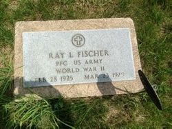
Ray Fischer
| Birth | : | 28 Feb 1925 Panama, Lancaster County, Nebraska, USA |
| Death | : | 23 Mar 1979 Adams, Gage County, Nebraska, USA |
| Burial | : | Highland Cemetery, Adams, Gage County, USA |
| Coordinate | : | 40.4580994, -96.5196991 |
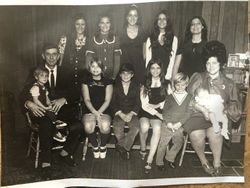
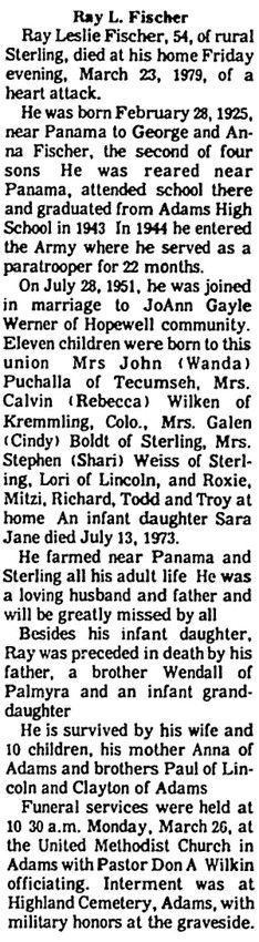
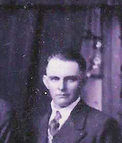
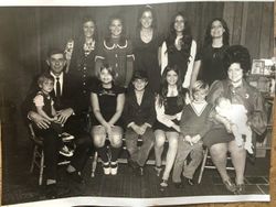
| Description | : | He Fischer was born on the family farm in the Pella community, rural Adams, Lancaster County, Nebraska. He received elementary education at Lancaster County Public Schools, District 20, "Wooden Shoe" located at 176th street and Firth road in rural Adams, Lancaster County, Nebraska. He graduated in 1943 from Panama High School in Panama, Lancaster County, Nebraska. He served in the United States Army. Ray was Farmer in rural Adams, Gage County, Nebraska his entire life. Ray Leslie Fischer and Joann Gayle Warner, daughter of John Charles Warner and Vesta Keebler, were married on July 28, 1951 at Hopewell Methodist... Read More |
frequently asked questions (FAQ):
-
Where is Ray Fischer's memorial?
Ray Fischer's memorial is located at: Highland Cemetery, Adams, Gage County, USA.
-
When did Ray Fischer death?
Ray Fischer death on 23 Mar 1979 in Adams, Gage County, Nebraska, USA
-
Where are the coordinates of the Ray Fischer's memorial?
Latitude: 40.4580994
Longitude: -96.5196991
Family Members:
Parent

Spouse
Siblings
Children

Flowers:


Nearby Cemetories:
1. Highland Cemetery
Adams, Gage County, USA
Coordinate: 40.4580994, -96.5196991
2. Hooker Cemetery
Adams, Gage County, USA
Coordinate: 40.4207993, -96.4732971
3. Grandview Cemetery
Gage County, USA
Coordinate: 40.4617004, -96.6091995
4. Granite Hill Cemetery
Johnson County, USA
Coordinate: 40.4180984, -96.4417038
5. Immanuel Cemetery
Sterling, Johnson County, USA
Coordinate: 40.4692001, -96.4253006
6. Latrobe Cemetery
Sterling, Johnson County, USA
Coordinate: 40.5151000, -96.4557000
7. Weber Cemetery
Sterling, Johnson County, USA
Coordinate: 40.4581000, -96.4177000
8. Saint Johns Lutheran Cemetery
Cortland, Gage County, USA
Coordinate: 40.5078300, -96.6252700
9. Firth Cemetery
Firth, Lancaster County, USA
Coordinate: 40.5250015, -96.6085968
10. Pella Cemetery
Panama, Lancaster County, USA
Coordinate: 40.5555992, -96.5014038
11. Saint John North Lutheran Cemetery
Sterling, Johnson County, USA
Coordinate: 40.4689500, -96.3878500
12. Sunnyside Cemetery
Cortland, Gage County, USA
Coordinate: 40.4799200, -96.6511800
13. South Saint John Lutheran Cemetery
Sterling, Johnson County, USA
Coordinate: 40.4355500, -96.3858000
14. Dietz Cemetery
Firth, Lancaster County, USA
Coordinate: 40.5449982, -96.6286011
15. Sterling Cemetery
Sterling, Johnson County, USA
Coordinate: 40.4585991, -96.3582993
16. Panama Cemetery
Panama, Lancaster County, USA
Coordinate: 40.5821991, -96.5255966
17. Zion Evangelical Lutheran Cemetery
Pickrell, Gage County, USA
Coordinate: 40.3456001, -96.6147003
18. Christ Lutheran Church Cemetery
Pickrell, Gage County, USA
Coordinate: 40.4079410, -96.6848370
19. Saint James Cemetery
Cortland, Gage County, USA
Coordinate: 40.4886050, -96.7036050
20. Cortland Cemetery
Cortland, Gage County, USA
Coordinate: 40.4879200, -96.7041250
21. Crab Orchard Cemetery
Crab Orchard, Johnson County, USA
Coordinate: 40.3274994, -96.4366989
22. Solon Cemetery
Otoe County, USA
Coordinate: 40.5917015, -96.4436035
23. Holland Cemetery
Holland, Lancaster County, USA
Coordinate: 40.5957985, -96.5997009
24. Rosehill Cemetery
Douglas, Otoe County, USA
Coordinate: 40.5845940, -96.3867900