
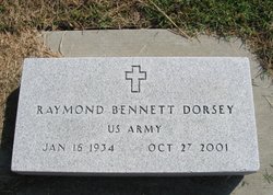
Raymond Bennett Dorsey
| Birth | : | 16 Jan 1934 Howard, Elk County, Kansas, USA |
| Death | : | 27 Oct 2001 Wichita, Sedgwick County, Kansas, USA |
| Burial | : | Bootle Cemetery, Bootle, Metropolitan Borough of Sefton, England |
| Coordinate | : | 53.4627680, -2.9787450 |
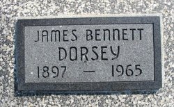
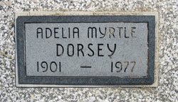
| Description | : | US ARMY Winfield Daily Courier Winfield, KS 29 Oct 2001 Raymond Bennett Dorsey, 67, of Wichita, died Oct. 27, 2001, at the Veterans Administration Medical Center in Wichita. Services will be 2 p.m. Wednesday at Greenlawn Cemetery in Grenola. Pastor Wallace Wartick will officiate. A memorial has been established with Hospice Inc. Contributions may be made through Zimmerman Funeral Home of Howard. Dorsey was born Jan. 16, 1934, in Howard, to Adelia Myrtle (Johnson) and James Bennett Dorsey. When he was 15, he went to work for Insul-Seal Insulation. In 1952 he entered the U. S. Army where he earned his General Equivalency Degree. He... Read More |
frequently asked questions (FAQ):
-
Where is Raymond Bennett Dorsey's memorial?
Raymond Bennett Dorsey's memorial is located at: Bootle Cemetery, Bootle, Metropolitan Borough of Sefton, England.
-
When did Raymond Bennett Dorsey death?
Raymond Bennett Dorsey death on 27 Oct 2001 in Wichita, Sedgwick County, Kansas, USA
-
Where are the coordinates of the Raymond Bennett Dorsey's memorial?
Latitude: 53.4627680
Longitude: -2.9787450
Family Members:
Parent
Siblings

Flowers:


Nearby Cemetories:
1. Bootle Cemetery
Bootle, Metropolitan Borough of Sefton, England
Coordinate: 53.4627680, -2.9787450
2. Walton Park Cemetery
Walton, Metropolitan Borough of Liverpool, England
Coordinate: 53.4564370, -2.9695960
3. Rice Lane Jewish Cemetery
Walton, Metropolitan Borough of Liverpool, England
Coordinate: 53.4521700, -2.9590600
4. St Mary the Virgin Churchyard
Walton, Metropolitan Borough of Liverpool, England
Coordinate: 53.4464930, -2.9673330
5. Aintree Racecourse Grounds
Aintree Village, Metropolitan Borough of Sefton, England
Coordinate: 53.4733880, -2.9549700
6. St. Mary's Churchyard
Bootle, Metropolitan Borough of Sefton, England
Coordinate: 53.4492620, -3.0006520
7. Kirkdale Cemetery
Liverpool, Metropolitan Borough of Liverpool, England
Coordinate: 53.4672530, -2.9479800
8. Ford Cemetery
Ford, Metropolitan Borough of Sefton, England
Coordinate: 53.4824040, -2.9925980
9. Everton Cemetery
Everton, Metropolitan Borough of Liverpool, England
Coordinate: 53.4555430, -2.9442480
10. Long Lane Jewish Cemetery
Liverpool, Metropolitan Borough of Liverpool, England
Coordinate: 53.4550140, -2.9420480
11. St. Alexander Church
Bootle, Metropolitan Borough of Sefton, England
Coordinate: 53.4401090, -2.9922250
12. St Luke Churchyard
Walton, Metropolitan Borough of Liverpool, England
Coordinate: 53.4396910, -2.9671400
13. Kirkdale Goal Cemetery
Kirkdale, Metropolitan Borough of Liverpool, England
Coordinate: 53.4361110, -2.9802780
14. Anfield Cemetery and Crematorium
Anfield, Metropolitan Borough of Liverpool, England
Coordinate: 53.4354680, -2.9578100
15. St. Mary's Cemetery
Kirkdale, Metropolitan Borough of Liverpool, England
Coordinate: 53.4323690, -2.9752500
16. St Faiths Churchyard
Waterloo, Metropolitan Borough of Sefton, England
Coordinate: 53.4810510, -3.0230370
17. St Peter and St Paul Churchyard
Crosby, Metropolitan Borough of Sefton, England
Coordinate: 53.4858300, -3.0234920
18. St. George Churchyard
Everton, Metropolitan Borough of Liverpool, England
Coordinate: 53.4252810, -2.9713940
19. Thornton Garden of Rest and Crematorium
Thornton, Metropolitan Borough of Sefton, England
Coordinate: 53.5001850, -2.9951960
20. St Luke Churchyard
Great Crosby, Metropolitan Borough of Sefton, England
Coordinate: 53.4909310, -3.0240300
21. West Derby Cemetery
West Derby, Metropolitan Borough of Liverpool, England
Coordinate: 53.4513790, -2.9154630
22. St. Anthony's Churchyard
Liverpool, Metropolitan Borough of Liverpool, England
Coordinate: 53.4223190, -2.9815350
23. West Derby Jewish Cemetery
Liverpool, Metropolitan Borough of Liverpool, England
Coordinate: 53.4504986, -2.9137393
24. Sefton Parish Churchyard
Sefton, Metropolitan Borough of Sefton, England
Coordinate: 53.5044060, -2.9712190